

thunderbolt
-
Posts
821 -
Joined
-
Last visited
Content Type
Profiles
Blogs
Forums
American Weather
Media Demo
Store
Gallery
Posts posted by thunderbolt
-
-
7 minutes ago, Allsnow said:
It’s not the cbs national game? If not, I will be watching red zone
Red zone all day babyRed zone all day baby
-
 1
1
-
 1
1
-
-
3 minutes ago, Amped said:
GFS digs the southern stream a lot more this run. End result, a TC phasing with a bomb cyclone.
You better hope that thing stays offshore, 250 miles west and it's hurricane force winds along almost the entire east coast.


Dammmmmmm
-
1
-
-
Just over 2 inches in the rain gauge Langhorne PA
-
6 hours ago, Maestrobjwa said:
Didn't know "real tropical poster" was a prerequisite for posting...lol Now I will admit my general geography skills aren't the best, but this I still say the image was kind of a quiz question because of there being no other point of reference visible (I'm used to looking at it in relation to Texas, lol)
Don’t worry he thinks Tallahassee is in central Florida lol
-
Invest 95L
95L.INVEST.15kts.1007mb.10N.25W
-
1
-
-
Just now, thunderbolt said:20 minutes ago, the ghost of leroy said:
See, when you say central west Florida I think of the panhandle between Panama City and Tallahassee.
20 minutes ago, the ghost of leroy said:See, when you say central west Florida I think of the panhandle between Panama City and Tallahassee.
The way I look at it is Naples is South Florida Tampa Bay Central Florida Tallahassee is North Florida at least according to Latitude
-
20 minutes ago, the ghost of leroy said:
See, when you say central west Florida I think of the panhandle between Panama City and Tallahassee
-
35 minutes ago, senc30 said:
Well, the 12Z GFS landfalled in Southwest Florida on September 22nd. That was an interesting run.
I would call that more central west Florida
-
-
2 hours ago, ldub23 said:
Euro shows nothing, 06GFS NADA. Nothing for peak.
Yo Pinocchio stop lying You might want to check to Euro again
-
1 hour ago, ldub23 said:
Backed way off of that. Sal isnt backing off though. 12Z gfs shows basically nothing thru peak while euro is showing "vigourous waves". Lets see if the afternoon euro actually shows a well developed storm in the MDR.
He said possible
-
35 minutes ago, Derecho! said:
Looking at ICON, the CMC, or the NAM for tropical meteorology leaves you with less knowledge about the tropics than you had before you looked at it.
You might wanna also add a GFS
-
 1
1
-
-
13 hours ago, yoda said:
lol using the ICON for tropical systems
Maybe you should start looking at it more often LOL
-
9 minutes ago, brentrich said:
I'm sorry but I'm newbie but what does 25/13/6 means? Does it mean 25 name storms / 13 hurricanes / 6 major hurricanes?
Yes
-
1
-
-
1 hour ago, raindancewx said:
Nino 4 looks like it could finish in the 29.0-29.4C range for April 2020. Not exactly a lot a strong cold or La Nina signal historically. In fact it seems almost impossible to get a strong or long-lasting La Nina with Nino 4 that warm going by the historical record. This is the composite of winters after 29.0-29.4C Nino 4 in April. Really only 1995-96, 2005-06, 2010-11 as La Ninas. Only 2010-11 is strong.
What’s your definition of strong?
-
https://www.wapt.com Follow this new station live from Jackson Mississippi
-
7 minutes ago, swva said:
 Cranking for the moment!
How about a couple videos
-
16 minutes ago, Maestrobjwa said:
Dang, we ran him away too? Smh We're running out of knowledgeable posters!
Where did Bob go ?
-
4 hours ago, Rhino16 said:
I’m not sure i get what you mean by getting the egg off your face... like, you’re hatching because last season was bad?
I believe what he saying His call from last year wasn’t his best and he is going to redeem himself
-
On Wed Mar 13 2019 at 1:19 PM, AfewUniversesBelowNormal said:
This is a pretty healthy -1 subsurface wave making it to 180W.. chances for La Nina go up.
When?
-
On Wed Mar 13 2019 at 7:24 PM, raindancewx said:
Derecho in TX too. This storm is probably important enough / powerful enough that it deserves some kind of name. I'm going with "Hurricane Kansas" until I see something better. It's not really just a blizzard, severe outbreak, flood, or wind storm, it's all that and more.
I-25 was closed north of Wagon Mound today since the wind was knocking big trucks off the road.
There were some 100 mph wind gusts in Southern NM earlier. Literally "more powerful than a locomotive".
Snow-pack numbers should be up more tomorrow after the heavy snows today.

this will never compare to a hurricane
-
17 hours ago, raindancewx said:
You keep saying I will be wrong. What if I'm right? Boston is at 0.1" officially. Doesn't look wrong to me. Boston has never had more than 60 inches in a low-solar El Nino back to 1892. I documented that extensively, and most of those years, all but two, 14/16, are under 45". 1977, 2002, 2014, all had high solar. 1995 was a La Nina with low solar. It isn't the right pattern for Boston to get heavy snow.
I've mentioned before the SOI in Sept-Nov is a good indicator for December. Looks good to me!
SOI Sept Oct Nov 1953 -13.0 -0.3 -2.7 2018 -8.5 2.6 -0.9 
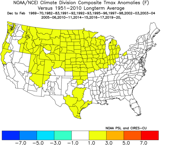
Does reality matter to you or not? I'll be waiting for your answer at the end of the month when the NE comes in warm. You still haven't answered whether you think its even possible for the NE to be warm in December in an El Nino, even though almost all of the recent ones are. Dirty little secret? The Cold El Ninos were already cold in the NE by this point. I know you don't care about reality, so this won't matter to you, but here is what the cold El Ninos look like in the NE by this point in Dec -


Depending on the area, I think just about the whole NE is +1 to +5, given what is coming later in the month, against 1951-2010 highs.
Why don't you just say + 1 to + 15 it's a good way to cover your ass and I will say -3 to +5
-
1
-
-
1 hour ago, Isotherm said:
Thanks frd and Ray. Should be interesting to see how this pattern evolves.
")
In Tom We Trust
-
1
-
-
Do you have a statistic where only half of November there was blocking and the other half there was not


Winter 2020-2021
in New England
Posted
Does anybody know when Tom’s Isotherm Winter outlook is coming out?