

thunderbolt
-
Posts
821 -
Joined
-
Last visited
Content Type
Profiles
Blogs
Forums
American Weather
Media Demo
Store
Gallery
Posts posted by thunderbolt
-
-
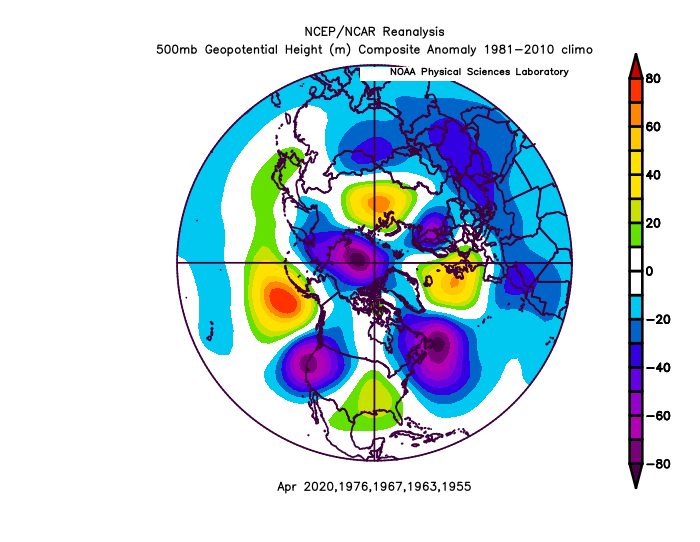
Dare I say 2001 repeat but this time Denver is feeling the pain just like Philly and New York felt it back in 2001
-
1 hour ago, raindancewx said:
I didn't have the big snows in the Northeast far enough south in my outlook. I thought they'd be NYC west/north. But with the NAO negative on net after a negative January it makes sense that the 'average' line for snow setup south of where I had it, over Philadelphia rather than New York City.
Many of the features I had did show up for the snow map. Notably, the lack of snow by the North Dakota/Montana border, heavy snow in the Midwest for places like Iowa (Des Moines I had at 150% in the raw analogs), and generally good snow totals for the interior West. I had the South generally below average. That was fine for the southeast, but not right south-central. Texas actually can get a lot of snow in the right type of La Nina. New Mexico will also tend to do well for snow in periods of very high +NAO OR very high -NAO periods. Only spot in the country with that distinction.
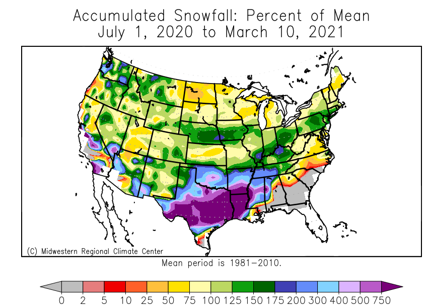
Some of the towns I look at in New Mexico have had one of their snowiest cold seasons to date for July 1-March 10.
Northern New Mexico:
Albuquerque: 13.7", 16th snowiest July 1-March 10 since 1931-32. Snowiest La Nina in that time frame. 5,300+ feet.
Clayton: 26.9", 12th snowiest July 1-March 10 since 1931-32 (there are some missing years here). Plains near OK/TX
Los Alamos: 38.0", 40th snowiest July-March 10 since 1931-32 (a few missing years). 7,300 feet. Notably well behind 2018-19 (63.1", 12th snowiest for the period).
Los Lunas: 13.4", 4th snowiest July-March 10 since 1958-59. South of Albuquerque, lower elevation by floor of the Rio Grande Valley, 4,800+ feet.
Eagle Nest: 93.9", 2nd snowiest July-March 10 since 1931-32 (some missing data). Elevation is 8,200+ feet here.
Southern New Mexico
Roswell: 10.9", 34th snowiest July-March 10 since 1931-32 (two missing years). 3,600 feet. SE New Mexico.
Hillsboro: 13.0", 17th snowiest July-March 10 since 1931-32. 5,200 feet. SW New Mexico
Gila Hot Springs: 20.2", Snowiest July-March 10 since 1957-58. 5,600 feet. SW New Mexico.
I personally put more stock in the AO being negative more than NAO In reference about the Northeast being colder than normal
-
35 minutes ago, CAPE said:
0z EPS implies flatter wave(s) damping with eastward movement early next week, a similar outcome to one of the common themes of the winter when there has been a strong vortex near the Canadian Maritimes- too much confluence in the wake.
GEFS digs a trough along the west coast, with more ridging in the east as the NA vortex departs quicker. Result is a more consolidated system tracking to the NW.
Pick your path to defeat, lol.
That’s weather if it happens it happens if it doesn’t it doesn’t we move on
-
2 minutes ago, StormchaserChuck! said:
This is 384hr right now
.thumb.gif.b7dc9f9bf805c189975e250c685ea1c1.gif)
Gotcha thank you
-
28 minutes ago, StormchaserChuck! said:
It's going to be historic -PNA March.
April of 5 matching analogs.
fwiw the Winter after is -NAO (these are La Nina -PNA March's the year before)
What do you mean by historic -pna
-
11 minutes ago, StormchaserChuck! said:
I want it to get warm. It's kind of warm today. I can't really feel -NAO anymore though..
May I ask what do you mean by feeling negative NAO
-
2 hours ago, StormchaserChuck! said:
Do you know that we are at a record now of cold 10mb
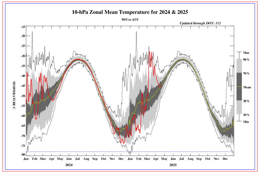
It usually goes right to +AO, no lag.
I’m glad this happened in March Instead of happening in January And the diagram that you’re presenting it also coincide when we had a negative a AO -3 to -4 at Times
-
44 minutes ago, raindancewx said:
I don't think the models really have the right idea for the cold in March. It looks like to me like there is a lot of warmth but also some powerful cold shots at times. I'm still fairly convinced there is one final big system for the Northeast, likely a Nor'easter, that moves through the Southwest first mid-month.
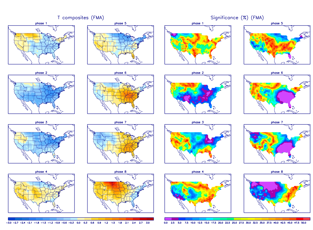
The MJO now looks like it could get into the fun phases for active weather too. I'm not sure I buy it sustaining the whole month. But the Euro probably has the right idea putting the MJO in phase 8 in early March. A run from phase 8 to phase 4 in March would be consistent with the variation I expect for Spring.
ECMF)
 I was hoping for phases six and seven
-
53 minutes ago, raindancewx said:
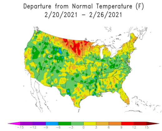
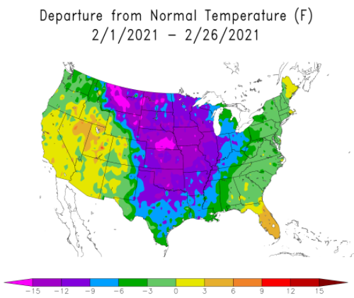
People in the future are probably not going to talk about the very warm week one and week four of February 2021 given how cold the middle of the month was.
I know where I live just north of Philly for the month of February will probably come in roughly -2 oh well it is what it is
-
2 hours ago, StormchaserChuck! said:
With the way the globe is pulsing right now. Very unlikely it will change between now and then.
Gotcha quick question for you then when was the last time the globe was pulsing like it is Now
-
33 minutes ago, StormchaserChuck! said:
By the way, if we get a -PNA in April, that will be a big time sign for next Dec-Feb (for -PNA).
So what you’re basically saying is anytime there’s a negative PNA in the month of April there’s a good chance that it’s gonna be Negative for the months of December January February
-
 1
1
-
-
1 hour ago, ravensrule said:
People have been asking that of you since Wright Weather. Maybe when you take your own advice I’ll think about listening to you.
Now that’s old-school
-
 1
1
-
-
Geez I really hope this comes to fruition it looks like the AO is gonna stay positive the NAO positive so we’re looking good get rid of all the snow we have here just north of the Philly It’s been above average snowfall here can’t wait till it’s all gone
-
13 minutes ago, donsutherland1 said:
Philadelphia: 0.8”
That seems about right I didn’t think anybody was expecting more than that anyway
-
1
-
-
Just now, JMcCaughey42 said:
Right by Woodbourne Train tracks
A friend of mine lives on fourth Street by the mall
-
1
-
-
Just now, JMcCaughey42 said:
Well as long as we change back sooner than later, should still get a great snowfall today.
Where in Langhorne are you located
-
Does anybody have the radar where the snow sleet line is
-
2 minutes ago, wdrag said:
I didn't initially know PHI had an advisory when looking at their map, I saw the green flood advisory superceded (hid) the brown wind advisory.
Wind advisories continue for PHI/OKX.
-
 1
1
-
-
19 minutes ago, StormchaserChuck! said:
La Nina is really asserting itself in the pattern (look at the constant ridging north of Hawaii)
http://mp1.met.psu.edu/~fxg1/ENSHGTAVGNH_6z/ensloopmref.html

Do you think La Niña reached its peak the only reason I’m asking it seems to me that region 3.4 is starting to slowly warm up
-
5 minutes ago, StormchaserChuck! said:
I was really wrong about this La Nina, it's really asserting itself. It will be interesting to see happens going forward, I was always thinking it could be a long term dull pattern. It would make sense for an event, maybe El Nino, to follow it.
If I may ask why do you think you’re so wrong
-
14 minutes ago, wdrag said:
Mount Holly NWS office. OKX is Upton-Brookaven. BOX is Taunton (Boston).
Gotcha I guess I’m not part of the Wind advisory i’m assuming it’s really pertaining to the Jersey Coast area
-
1
-
-
What does PHI stand for
-
1 hour ago, Prospero said:
I was just outside enjoying a beer and a gust came up that almost knocked over one of our porch umbrellas that has over 100 lb of blocks on its base. That has not happened since we put it up in July with all of our strong afternoon thunderstorms that we get. And we are all the way up in the Tampa Bay area.
The umbrella is now down, tied up, and put away for the next week or so. Doing more tonight that I planned on for the morning already. We have a yard of projectiles and objects that are not TS wind friendly. (My wife who was in Andrew nags at me about what "could" happen if we get a strong storm. They were not able to get out of their destroyed second floor condo due to landscaping gravel that had been picked up and piled up in front their door overnight.)
The million dollar question is did you Save the beer
-
2
-
-
1 hour ago, 40/70 Benchmark said:
This week.
Thank you
.gif.4e83777ba47aa1195ceb066ed6ad4bc7.gif)
Front Range snowstorm nowcast/conditions 3/13-15
in Central/Western States
Posted
Congrats to everybody who got Buried