

thunderbolt
-
Posts
821 -
Joined
-
Last visited
Content Type
Profiles
Blogs
Forums
American Weather
Media Demo
Store
Gallery
Posts posted by thunderbolt
-
-
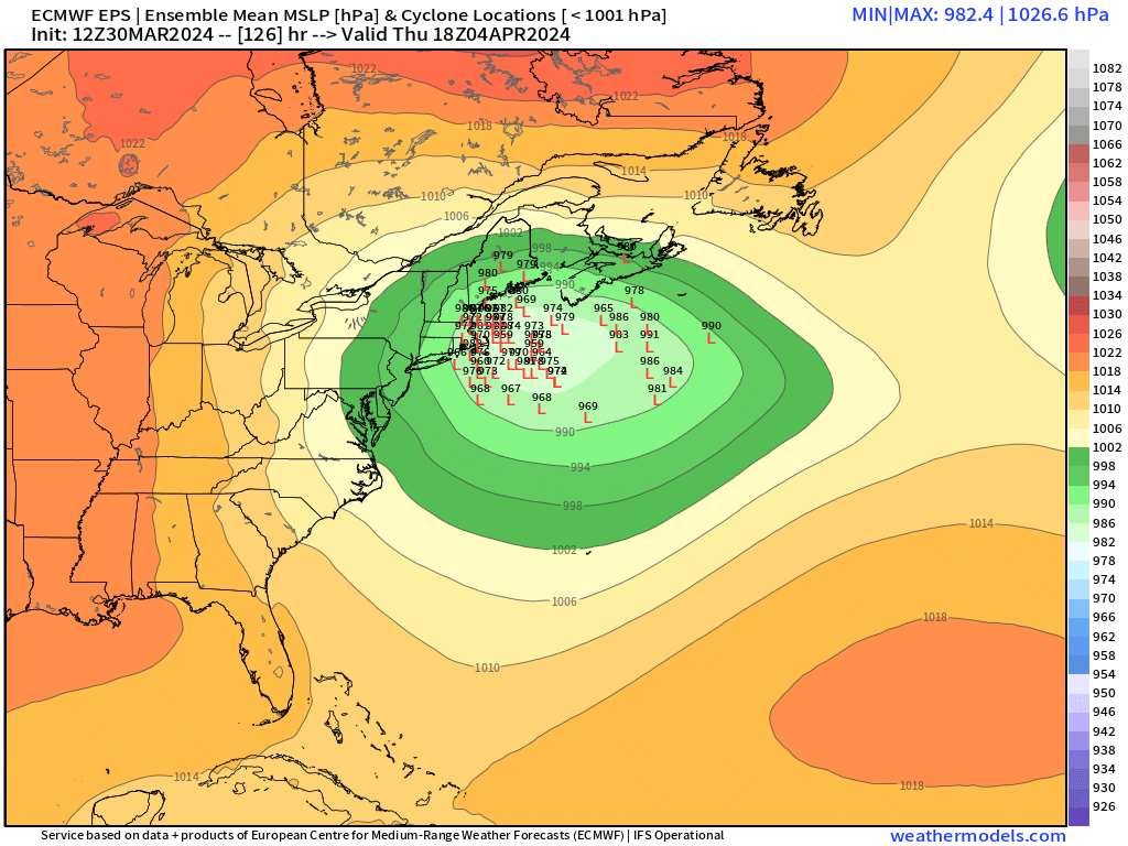
2 minutes ago, ORH_wxman said:
Individual EPS. You can see how slow-moving it is. There’s also still some spread with some members trying to escape the low to the northeast before it gets captured.


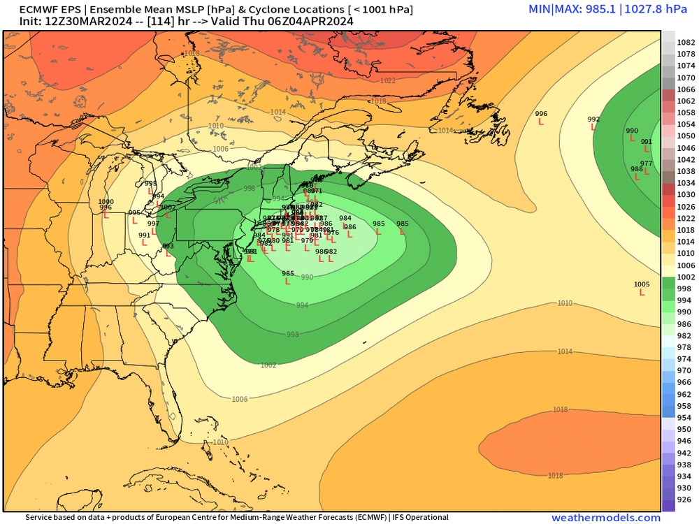
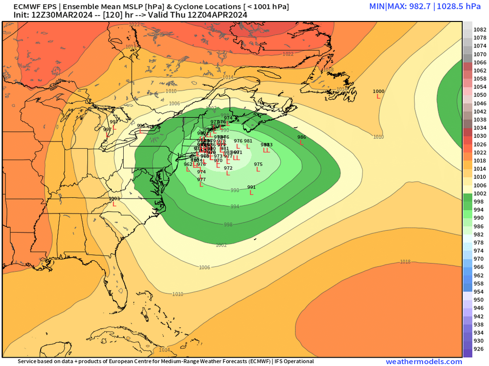
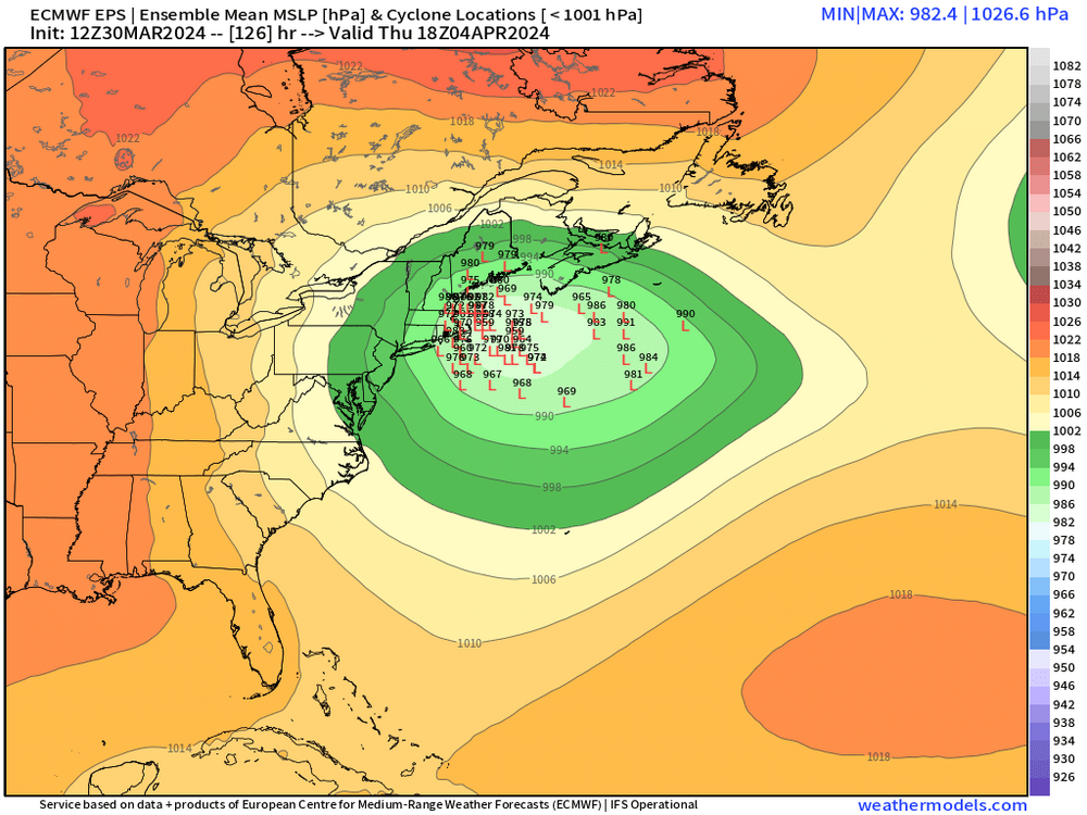
Some heavy hitters in there
-
 1
1
-
-
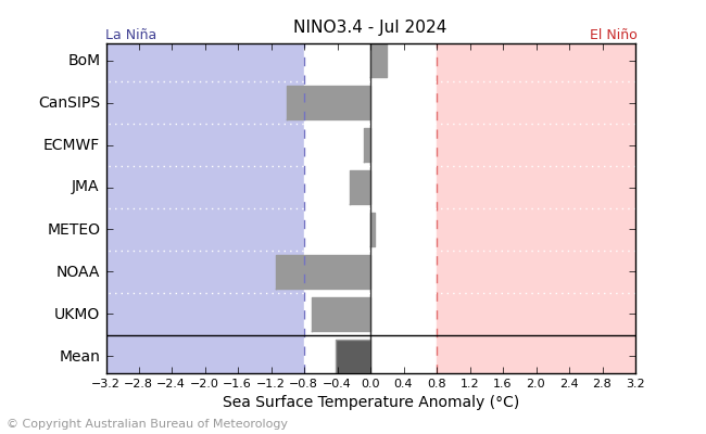 Up to July
-
42 minutes ago, Stormchaserchuck1 said:
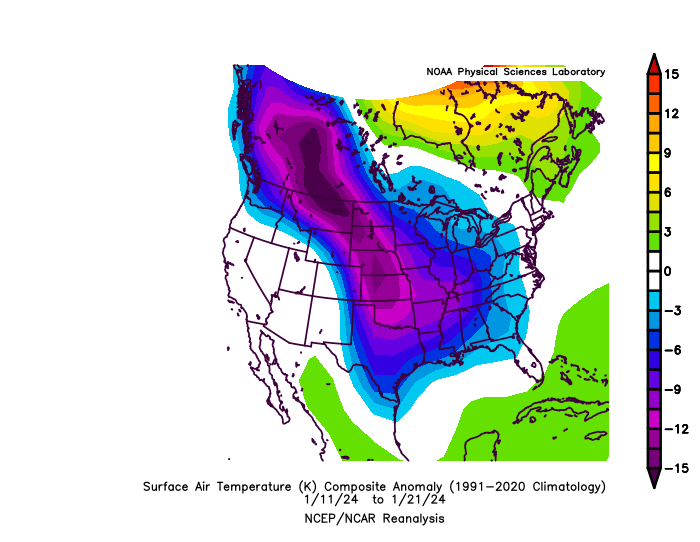
The MJO went through phases 3-4-5 the only time it was cold this Winter, Jan 11-21. The rest of the Winter was mostly warm for the CONUS
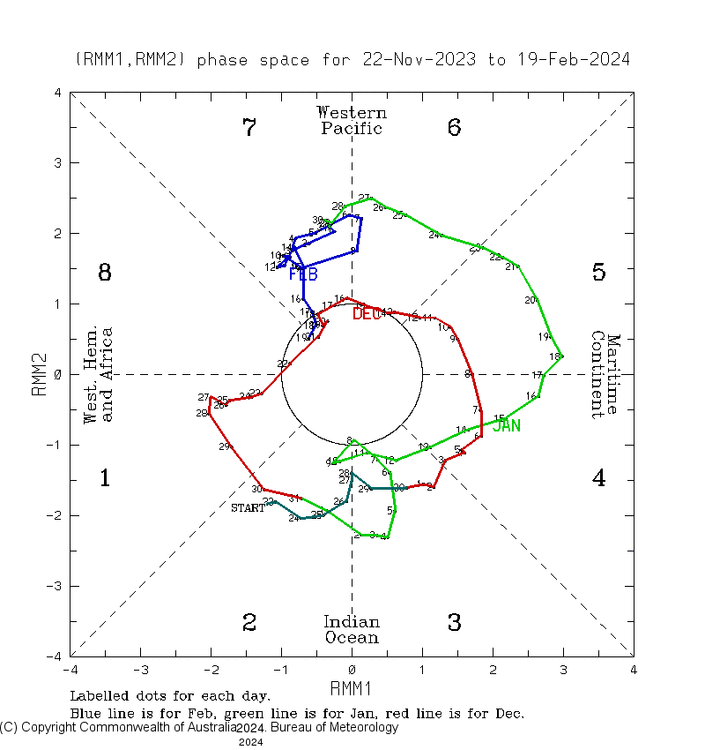 from December 22 to Jan 13 was in a cold phase
-
1
-
-
1 hour ago, yoda said:
Made a hard uturn in the past few days and is now forecast by 2 out of the 3 to enter the COD
-
31 minutes ago, Yeoman said:
It's hour 240
Thoughts on HR 300 on GFS
-
 1
1
-
 3
3
-
 1
1
-
-
Depicting Inland Watches/Warnings on Cone
- New experimental cone graphic depicting inland U.S. tropical storm and hurricane watches and warnings will become available in 2024
- Will help convey wind hazard risk
- Graphic may not be available as soon as the current cone graphic due to the time need to compile complete inland watch and warning information
- Will be available beginning on or around August 15, 2024
Department of Commerce // National Oceanic and Atmospheric Administration // 1
-
15 minutes ago, Yeoman said:
The epic pattern that was supposed to start next week?
No the week of the 14th
-
1 hour ago, Yeoman said:
Time to dust off the crochet kit
I guess you’re not liking this time period Coming up
-
1 hour ago, psuhoffman said:
I am not being snarky, I am genuinely curious how you think we should talk about the long range then? I have no issue with your methodologies but as far as I know none of them are helpful with diagnosing long range patterns. Pressure differences between DC and Pitt aren't going to help us glean anything about something 2-3 weeks away. So my honest questions is, how would you prefer the discussions in the long range thread be centered?
Well said
-
2 hours ago, frd said:
From Tomer , here is his update from 5 days ago, so keep that in mind. He seems bullish for a Moderate to Major Mid Atlantic Snowstorm
January 25 Update I typically like to provide general windows for snow potentials once the picture becomes somewhat clearer; in the following days since this post, I feel increasingly confident in narrowing down a potential window between around February 15-25 for the peak potential of a moderate-major Mid Atlantic and Northeast snowstorm, though a low potential exists as early as the 2nd week of February.Really this guys making a predicament, and it’s possibly 15 to 25 days away and even calling out possibly a major wow this guys got some big balls anybody know what this guy’s track record
-
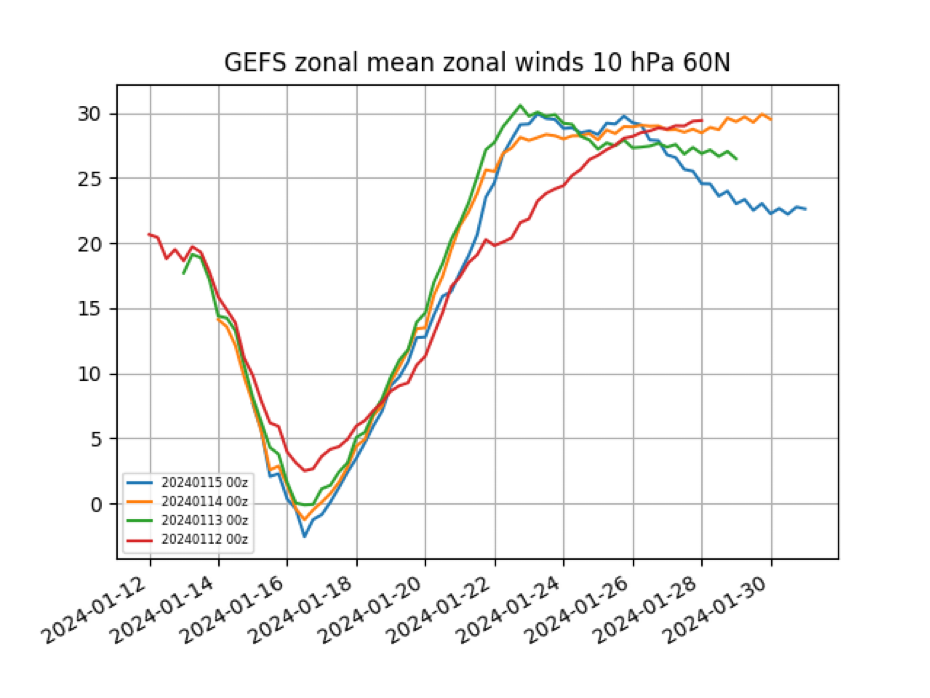
3 hours ago, GaWx said:
-This pattern is further evidence of the already known GEFS bias toward too strong of an SPV.
-Latest GEFS (your blue line) has dropped to a not too shabby -2.5. It may drop a little more in tomorrow’s run.
-This is a 10 mb reversal along with a split but without a simultaneous 10 mb warming. So, I don’t know whether Jan of 2024 will be credited in datasets as having had a major SSW.
-There already was an impressive 10 mb warming 12/29-1/6. Since there was no reversal then, that was initially considered a minor SSW. And now comes a reversal 10 days later.
-Could this be counted as a lagged major SSW when all is said and done? Quite possibly. There was a warming peak in late Jan of 2010 and the attendant 10 mb winds dropped to ~+1 to +2 m/s but the actual reversal wasn’t til ~2/9/2010. This is counted in some datasets as a late Jan 2010 major SSW and in others as a Feb 9, 2010, major SSW.
- Will there be a detectable lagged effect on the troposphere (a new -NAO/-AO combo) later? The average lag is ~2 weeks but it can take 4 weeks. Fwiw, the last few Euro Weeklies have shown a new -NAO/-AO combo for Feb 12-26, which would mean a start ~3.5 weeks after the Jan 16th reversal.
Here’s today’s update of the non-Euro models, which again all show a reversal Jan 15-16:

Nice work there GA
-
2
-
1
-
-
21 hours ago, GaWx said:
Today’s non EPS 10 mb strat wind update has 100% of the GEFS members with a reversal on Jan 16th (averaging -1.25 m/s). This is just two days after none of the members had one! The other models also have a reversal Jan 15-16 with the GEPS still the strongest:

Edit: today’s EPS agrees a reversal is coming:

-
1
-
-
6 minutes ago, 40/70 Benchmark said:
We need to get you guys to just hug it out this spring.
Lol
-
1
-
-
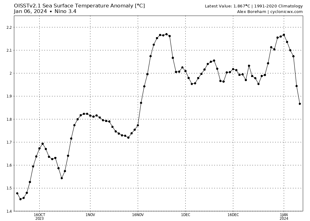
3 hours ago, snowman19 said:
Once again, you have no idea what you’re talking about. This is still going to be an official super El Niño. You lost, admit it. You’re embarrassing yourself right now.

Enjoy your week buddy. with your 2.1. 2.3 lol
-
1
-
-
1 hour ago, snowman19 said:
You have absolutely no idea what you’re talking about. None, clueless. You’re really, really bad at this. Stop, just stop. This is going to be an official trimonthly super El Niño. The ONI is for NDJ going to be over +2.0C (super). You lose, game over, give it up. You are making yourself look delusional and even more ridiculous

, stop using a coral reef anyway, I hope you have a great week. You could always look forward to next year.lol0.82023-0.7-0.4-0.10.20.50.81.11.31.61.81.9
-
Man that’s a lot of purple

-
1
-
-
43 minutes ago, 40/70 Benchmark said:
I see what you said. Its a deflection away from acknowledgment of the fact that the 2.0+ ONI crowd may be correct. Pointing out that there is not a "super" category is a strawman contention...its irrelevant.
True, but it’s not gonna come to fruition 2.0. Close, but no cigar. I can see December maybe January coming in at 2. But not February. and as you know you need three months straight of 2.0 also, I admire your work to also and your outlook so far is been spot on. Keep up the great work.
-
2
-
-
Just now, thunderbolt said:
Not disputing that whatsoever. Look what I said earlier.
2 hours ago, 40/70 Benchmark said:If the ONI peaks at 2.0, then the guys calling for a super peak were correct.
Period.
Does it mean another shit winter? No, especially not with abundant blocking.
In the reference about the winter, it is what it is I could care less
-
1
-
-
2 hours ago, 40/70 Benchmark said:
If the ONI peaks at 2.0, then the guys calling for a super peak were correct.
Period.
Does it mean another shit winter? No, especially not with abundant blocking.
Not disputing that whatsoever. Look what I said earlier.
-
34 minutes ago, GaWx said:
1. But if ONI peak were to end up +2.00+, why wouldn’t it be known as a low end super? I don’t follow you.
2. Now regarding RONI, which many have been saying is more relevant to sensible wx, it looks to most likely peak in only low end strong.
Let me also state, I respect you you’re probably one of the best posters on this format. There’s certain individual so I could care less about. He’s just a shit stir that’s it. Because if you go against his agenda, he calls you troll. Or he make fun of you.
-
Just now, thunderbolt said:
There’s no such thing as a low end super when all said and done, the government will recognize it as a strong El Niño, it’s only been positive for roughly about a month and a half other than that you need three months of consecutive 2.0 to clarify that as a super not happening, especially as of right now.

-
30 minutes ago, GaWx said:
1. But if ONI peak were to end up +2.00+, why wouldn’t it be known as a low end super? I don’t follow you.
2. Now regarding RONI, which many have been saying is more relevant to sensible wx, it looks to most likely peak in only low end strong.
There’s no such thing as a low end super when all said and done, the government will recognize it as a strong El Niño, it’s only been positive for roughly about a month and a half other than that you need three months of consecutive 2.0 to clarify that as a super not happening, especially as of right now.
-
27 minutes ago, GaWx said:
1. But if ONI peak were to end up +2.00+, why wouldn’t it be known as a low end super? I don’t follow you.
2. Now regarding RONI, which many have been saying is more relevant to sensible wx, it looks to most likely peak in only low end strong.
There’s no such thing as a low end super when all said and done, the government will recognize it as a strong El Niño, it’s only been positive for roughly about a month and a half other than that you need three months of consecutive 2.0 to clarify that as a super not happening, especially as of right now.
-
 1
1
-
-
22 minutes ago, GaWx said:
1. But if ONI peak were to end up +2.00+, why wouldn’t it be known as a low end super? I don’t follow you.
2. Now regarding RONI, which many have been saying is more relevant to sensible wx, it looks to most likely peak in only low end strong.
There’s no such thing as a low and super
-
1
-


2024-2025 La Nina
in Weather Forecasting and Discussion
Posted
Really