

thunderbolt
-
Posts
821 -
Joined
-
Last visited
Content Type
Profiles
Blogs
Forums
American Weather
Media Demo
Store
Gallery
Posts posted by thunderbolt
-
-
How is El Niño shaping up?
While referencing a 30-year sea level record, @NASA scientists are tracking changes in ocean height.
This year’s El Niño seems modest compared to extreme events in 1997 and 2015, but it could still intensify.
-
 1
1
-
-
7 hours ago, bluewave said:
Perfect balance of blocking near Greenland and Alaska with a great SW ridge near California. It was the only time a station on Long Island had a 90” season. It might have been a 100 to 200 year event if we had snowfall data going back that far on Long Island. It was as close to a perfect winter and snowfall season that our area has had in modern times. A great KU, high number of days with snow cover, and wall to wall cold from November into April but not overpowering. On a scale of 100 for ranking a winter, it would probably be the only year in my lifetime that I would grade a 95 or higher A+. I would probably rank the 10-11 and 77-78 seasons a close 2nd around 90.

https://www.bnl.gov/weather/4cast/monthlysnowfall.htm
-
1
-
-
-
-
22 minutes ago, bluewave said:
It’s been really warm here this month. There are a number of stations in New England that are still close to +5. The upper 70s dew points earlier this month we’re off the charts for this part of the country.

https://x.com/blizzardof96/status/1705905438200410159?s=42&t=9oYN55kJQkQ18l6qbtT9mw
-
1
-
-
-
7 minutes ago, HoarfrostHubb said:
He got home. He wasn’t trapped or anything. Just gridlocked.
Lots of issues in that city tonight
Multiple water rescues taken place
-
 1
1
-
1
-
-
33 minutes ago, SnoSki14 said:
The SSTs helped it rapidly intensify but it's never enough to overcome the shear which is clearly having an effect this morning.
I read the sheer supposed to lesson up later in the day
-
1
-
-
13 minutes ago, NorthHillsWx said:
Lee may reach cat 4 by 5 pm. This thing is absolutely going off at the moment
Check out the lightning wrapping around it you know it’s balls to the wall now baby
-
1
-
-
-
21 hours ago, GaWx said:
-Usually the best bet for an E MDR system since 75%+ don't hit the US although nowhere near a safe bet at least yet imo
-12Z UKMET: still has TCG but unlike the prior run having TCG on Sunday, this waits til Wednesday (9/6). With the delay, it is notably weaker but is still in a potentially dangerous position at 168 (9/8) 300 miles E of the Leewards moving WNW at 15 mph:
NEW TROPICAL CYCLONE FORECAST TO DEVELOP AFTER 120 HOURS
FORECAST POSITION AT T+120 : 14.2N 44.1WLEAD CENTRAL MAXIMUM WIND
VERIFYING TIME TIME POSITION PRESSURE (MB) SPEED (KNOTS)
-------------- ---- -------- ------------- -------------
1200UTC 06.09.2023 120 14.2N 44.1W 1010 27
0000UTC 07.09.2023 132 14.1N 46.7W 1009 29
1200UTC 07.09.2023 144 14.9N 49.0W 1007 37
0000UTC 08.09.2023 156 15.4N 51.8W 1007 31
1200UTC 08.09.2023 168 16.1N 54.9W 1007 34Just going to be an ace producer that’s it
-
1
-
-
I smell a fish
-
1
-
-
Tweet from HM We have seen a reflecting kelvin wave and off equator Rossby progress westward over the last few weeks. This has actually flipped the current. It's not strong enough to collapse the event, but it will help to continue to expand the warmth west and poleward.
-
1
-
-
-
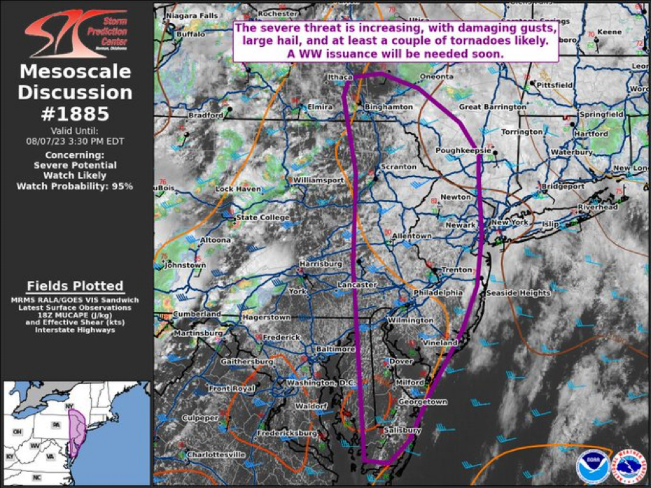
9 minutes ago, SmokeEater said:
Snippet from the latest SPC outlook for our area, most of the subforum is now in 5% tornado risk.
The parameter space should be favorable for severe well after dark, with 40-50 kt effective-shear magnitudes, locally enlarged hodographs with 200-300 J/kg effective SRH, and around 1000-2000 J/kg MLCAPE. Convective coverage is uncertain, but all hazards will be possible.
Sent from my SM-S901U using Tapatalk
-
-
3 hours ago, snowman19 said:
Once again, it is not even worth looking at model projected forcing 4+ months from now. This has been said ad nauseam. I don’t care what it shows for forcing, east-based, west-based, central-based. Once again, let’s see where the forcing is in November. Remember the great forcing the models were showing at this point in time for the 19-20 winter???
Everyone run and hide before the ENSO eats us all alive
It’s going to be truly frightening when we see a strong to super east-based Nino in full force this fall . I’m actually looking forward to experiencing one, I was too young for 97-98
")
-
1
-
-
-
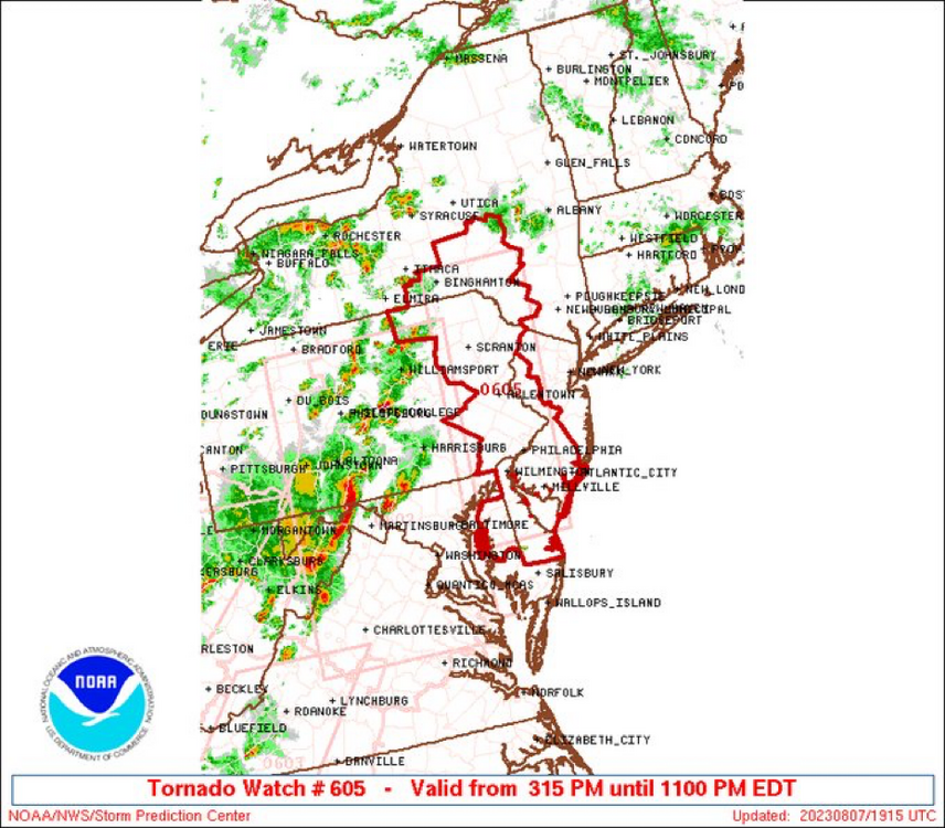
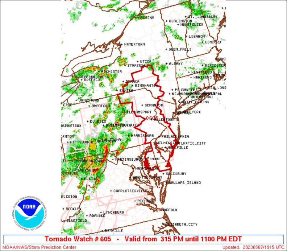
2 minutes ago, mattinpa said:
Tornado watch officially issued for the whole area until 11 PM
-
 1
1
-
-
-
-
-
-
1 hour ago, bluewave said:
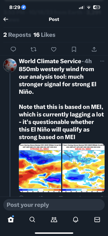
It’s a pretty big jump at this point to even talk about specific winter El Niño comparisons when the July forcing is still well west of where it usually is for a developing El Niño. This is a function of how warm the WPAC back to the IO still is for a developing El Niño. While Nino 1+2 to 3 is very warm for this time of year, the actual SSTs are much warmer west of the Dateline. So it’s still too early to know how much the winter forcing will resemble an El Niño if the WPAC remains as warm.
Notice how seasonal models like the Euro went to a stock summer forcing composite for a developing east based El Niño. While it did have some forcing west of the Dateline, that forcing turned out much stronger and further west. The EPAC forcing never developed. So we have to ask how well these seasonal models will perform 5-6 months out when they can’t get the first 3 months correct?


Euro summer forecast
Verification so far much different

Well said blue I think what it is is since we had such a lousy winter last year you grasp anything that looks positive even though it’s 5 to 6 months ahead
-
3
-


El Nino 2023-2024
in Weather Forecasting and Discussion
Posted