

thunderbolt
-
Posts
821 -
Joined
-
Last visited
Content Type
Profiles
Blogs
Forums
American Weather
Media Demo
Store
Gallery
Posts posted by thunderbolt
-
-
You shouldn’t call people names that’s not nice Ben Noll always uses OISST not CRW. With weeks and weeks of warming (WWBs/DWKWs) yet to go, it's obvious at this point that it's going to exceed +2.0C. @roardog He used the CRW SST map yes, but he uses OFFICIAL readings (OISST). The last OISST on cyclonicwx was in the verge of going above +1.8C. Nice troll
-
022-1.0-0.9-1.0-1.1-1.0-0.9-0.8-0.9-1.0-1.0-0.9-0.82023-0.7-0.4-0.10.20.50.81.11.31.61.81.9
-
8 minutes ago, GaWx said:
Absent a steep fall in 3.4 the rest of the month, there’’d actually be a very good chance for a super as unrounded NDJ ONI (ERSST, which has been running slightly warmer than OISST for several months) would be +2.00+. ND is ~+2.05.
Did you see November came in at 1.9
ME 2023-2024 1.1 1.3 1.6 1.8 1.9 -
 1
1
-
-
3 minutes ago, GaWx said:
Absent a steep fall in 3.4 the rest of the month, there’’d actually be a very good chance for a super as unrounded NDJ ONI (ERSST, which has been running slightly warmer than OISST for several months) would be +2.00+. ND is ~+2.05.
3 minutes ago, GaWx said:Absent a steep fall in 3.4 the rest of the month, there’’d actually be a very good chance for a super as unrounded NDJ ONI (ERSST, which has been running slightly warmer than OISST for several months) would be +2.00+. ND is ~+2.05.
Not with all that cold water coming up I don’t think it’s going to happen. I think it’s over you need three months of 2.0 to clarify as a super not gonna happen
-
1
-
-
1 minute ago, GaWx said:
Absent a steep fall in 3.4 the rest of the month, there’’d actually be a very good chance for a super as unrounded NDJ ONI (ERSST, which has been running slightly warmer than OISST for several months) would be +2.00+. ND is ~+2.05.
-
1
-
-
On 12/30/2023 at 12:40 PM, snowman19 said:
Awesome call!!!

Thanks I’ll try my best. Maybe you and I could sit down and have a beer and we can talk about next year
-
1
-
-
For those who were picking the super not happening, maybe next year
-0.7 -0.7 -0.6 -0.3 -0.2 0.1 0.2 0.3 0.3 WL 2017-2018 0.1 -0.1 -0.4 -0.7 -0.8 -1.0 -0.9 -0.9 -0.7 -0.5 -0.2 0.0 WE 2018-2019 0.1 0.2 0.5 0.8 0.9 0.8 0.8 0.7 0.7 0.7 0.5 0.5 2019-2020 0.3 0.1 0.2 0.4 0.5 0.6 0.5 0.5 0.4 0.2 -0.1 -0.3 ML 2020-2021 -0.4 -0.6 -0.9 -1.2 -1.3 -1.2 -1.1 -0.9 -0.8 -0.7 -0.5 -0.4 ML 2021-2022 -0.4 -0.5 -0.7 -0.8 -1.0 -1.0 -1.0 -0.9 -1.0 -1.1 -1.0 -0.9 WL 2022-2023 -0.8 -0.9 -1.0 -1.0 -0.9 -0.8 -0.7 -0.4 -0.2 0.1 0.5 0.8 ME 2023-2024 1.1 1.3 1.6 1.8 1.9 ENSO Type Season JJA JAS ASO SON OND NDJ DJF JFM FMA MAM AMJ MJJ -
1
-
-
10 hours ago, snowman19 said:
Awesome call!!!
How’s your 2.3 working out for you? And you’re super El Niño not gonna happen when all said and done you’re gonna lose anyway, I hope you have a great new year
-
 1
1
-
1
-
-
Bye-bye
-
 1
1
-
1
-
-
1 hour ago, 40/70 Benchmark said:
If we ever 5 PPD weenies, then he would need a new outlet lol
Lol
-
1
-
-
46 minutes ago, snowman19 said:
In other news, the SOI is -36And CRW, even the CDAS is warming:
That won’t last long it will be below 2 in let’s say two weeks at max
-
1
-
-
5 minutes ago, snowman19 said:
Delete your account
Relax buddy I didn’t mention your name
-
1
-
1
-
-
1 hour ago, GaWx said:
The 3.4 OISST is not going in the right direction if you want a super Nino:

No, it’s not I guess for those who were predicting a super El Niño now I guess they will just have to wait for the next El Niño for those who were predicting a strong El Niño Congratulations.
-
1
-
1
-
-
https://x.com/chris88808568/status/1735098825801433259?s=42&t=9oYN55kJQkQ18l6qbtT9mw It’s over for those who are predicting a super El Niño
-
1
-
-
7 hours ago, GaWx said:
The strat stuff discussed by Cohen and others is so fascinating! To me, getting a major SSW resets the whole winter playing field. It is like getting a new QB and perhaps even more like getting a whole new team mid-game.
Here’s something I found recently:
In this, I noticed these things:
-QBO: E beat W by a large margin, 22 to 13
-QBO E: 14 displaced vs 8 split
-QBO W: 4 displaced vs 9 split
-QBO E El Niño: 6 displaced vs 3 split
-QBO W El Niño: 2 displaced vs 4 split
-Best bet for one is QBO E La Nina followed closely behind by QBO E El Niño
-El Nino had 15 from 12 winters (out of total of 20 winters) and La Niña had 13 from 11 winters (out of total of 18 winters), but neutral had only 7 from 7 winters (out of total of 18 winters)
-To get two in one winter, you almost always have to have first one by Dec
Nice work there GA
-
1
-
 1
1
-
1
-
-
5 hours ago, frd said:
MJO phase significance changes based on the three month period you are in.
By chance do you have a composite that shows a warm look with a .5 or greater with El Niño
-
Just now, thunderbolt said:
One is not a warm phase for December

That also goes for number two
-
1
-
-
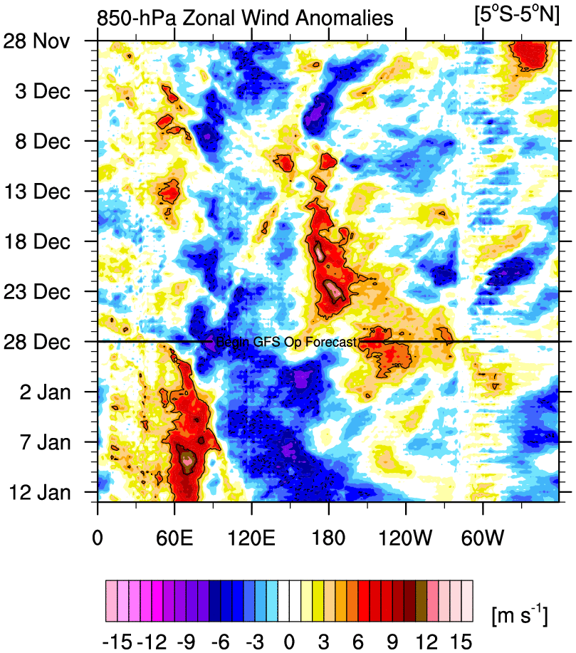
3 hours ago, frd said:
Interesting post by @bluewave
One of the main issues with the longer range model forecasts for the MJO beyond 10 days is that the ensembles weaken the convective signal too much. This is also true with the RMM charts. So some of the posts on twitter stating that the MJO will quickly weaken or progress to 8-1-2 are basing that on an an inherent model bias. So it’s no surprise that the convection in the warm phases this week is verifying more intense in the warm phases than the runs back in late November were indicating. This is one of the reasons ensemble forecasts have been correcting warmer for December than they were indicating later in November. So even if the MJO can eventually get over into phase 8-1-2, that is also a warmer signal from December into January with an El Niño.
New run

Old run

One is not a warm phase for December
-
1
-
-
20 hours ago, George001 said:
Good read. We don’t always agree, but I respect the transparency about your previous outlooks. I wish more seasonal forecasters would be as open about the results of their previous forecasts. It appears that we agree about the pacific, and where our forecasts differ is the polar domain. I’m solidly in the 1972-1973, 1991-1992, 2018-2019 camp. Considering that you are forecasting nearly twice as much snow for my area as I am, I hope you are right.
Did you post your outlook ?
-
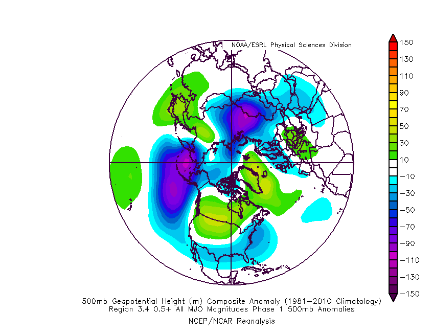
25 minutes ago, griteater said:
It depends on the time of year. On average, Phase 1 in late Nov has a trough on the west coast...in late Dec, trough on east coast.
Link: https://www.atmos.albany.edu/facstaff/roundy/waves/rmmcyc/index200reg.html
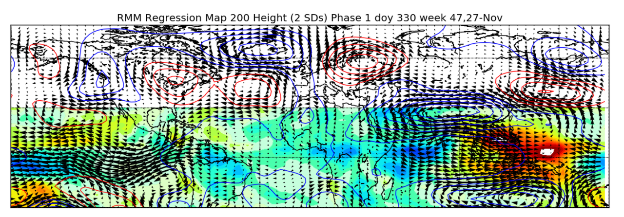
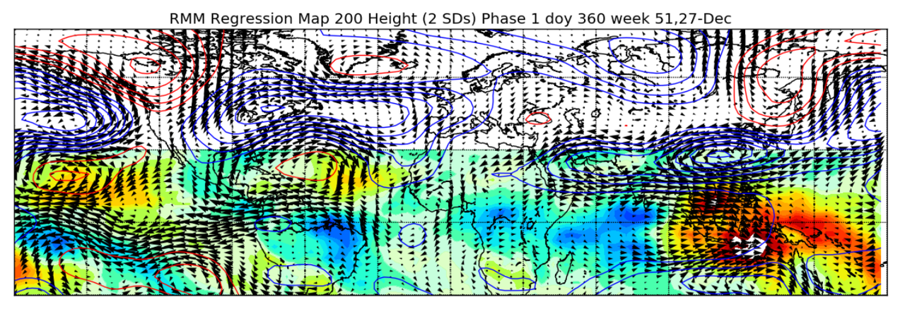
Phase1 when El Niño is greater than .5
-
4
-
1
-
-
1 minute ago, stadiumwave said:
But that next Kelvin Wave, like those strong westerlies, will bump it up to 2.5. Oh wait, the westerlies didn't bump it up.
I feel like for 6 weeks, it's always that next big thing....and this Nino will show its monstrosity....except it never does.
Lol
-
2
-
-
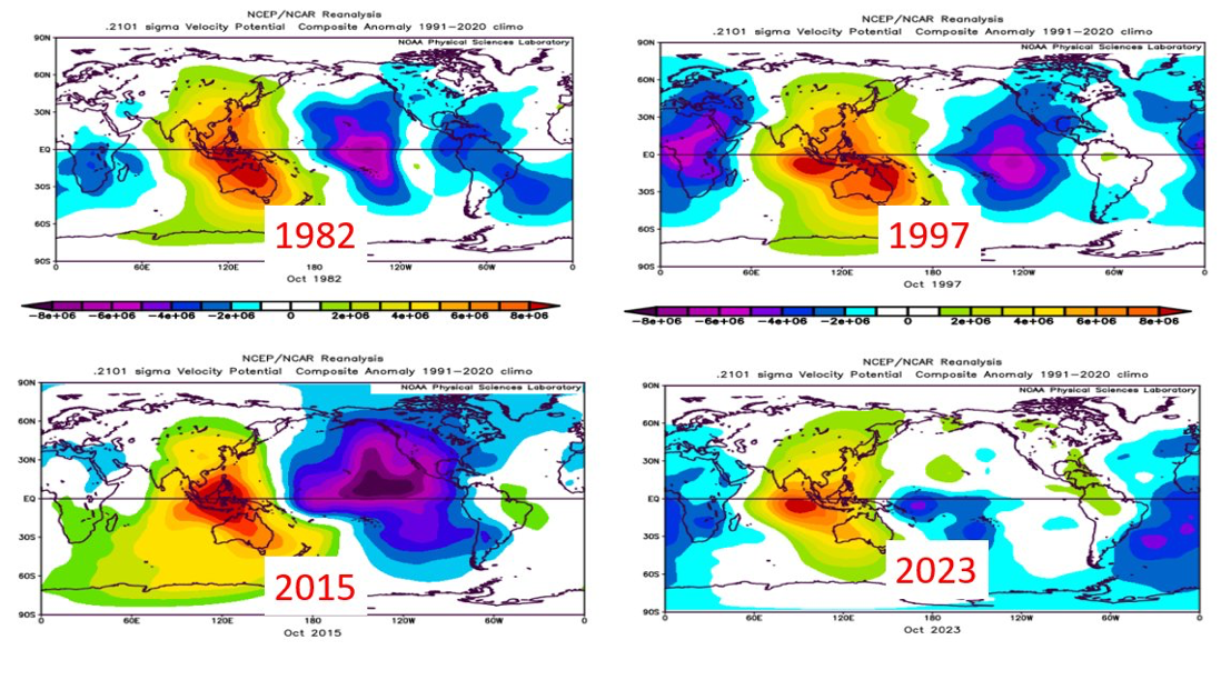
As we've discussed extensively in our recent client reports and Webinars, while ocean temperatures are suggestive of a strong El Nino event, the atmospheric response in the central/eastern tropical Pacific looks nothing like other recent strong El Nino events. Here, you can see the tropical atmospheric response, illustrated by the 200 mb velocity potential, from the month of October for 1982, 1997, 2015, and 2023.
You don't have to completely comprehend what the heck velocity potential is to see that the 2023 event has a much weaker, more smeared signal in the central/eastern tropical Pacific than the other events did. The previous events were characterized by strong rising motion (blues/purples) east of the dateline, while the current event is characterized by weaker rising motion closer to the dateline.
 tweet from Todd Crawford
-
1
-
1
-
-
18 minutes ago, Amped said:
Forecast has it going west of Acapulco, but way too close for comfort.
Yes, I don’t know how far west it’s going to be from there, but regardless, it should be on a dirty side of the storm storm surge should be pretty intense with definitely some heavy rains and very strong winds
-
1
-
-
8 minutes ago, 40/70 Benchmark said:
Who tweeted that?
David Birch ocean, data analyst
-
1
-
1
-


El Nino 2023-2024
in Weather Forecasting and Discussion
Posted
That’s fair, but when all said, and done this year’s gonna be known as a strong El Niño, not super no ifs or butts about it