

Lookout
-
Posts
5,769 -
Joined
Content Type
Profiles
Blogs
Forums
American Weather
Media Demo
Store
Gallery
Everything posted by Lookout
-
Hell with that weak crap.......get the good stuff.
-
ffc has gone back to mid to upper 80s here all week. ****!
-

Major Hurricane Florence: STORM MODE THREAD
Lookout replied to stormtracker's topic in Tropical Headquarters
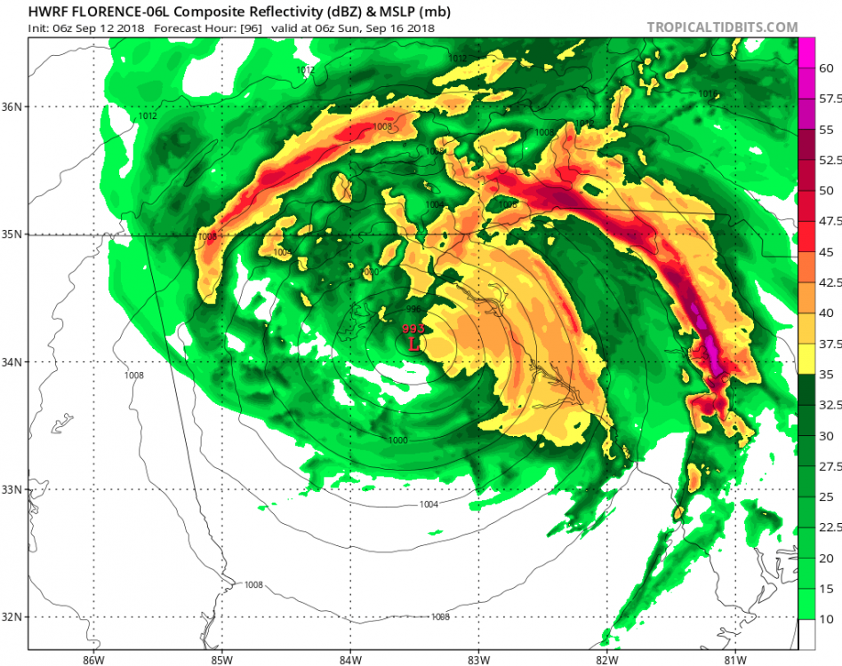
I've been thinking totals seem too low too considering how long that band has been there. (or at least there has to be totals higher than those between stations) Wonder how accurate this station is? It shows around 48 inches since thursday. https://www.wrh.noaa.gov/mesowest/timeseries.php?sid=RDKN7&num=72&banner=gmap&raw=0&w=325 -
got to 97 here yesterday...same for athens....absolutely ridiculous. . Even with a lot of cloud cover it's still 90. At least there is a 20mph breeze today. Sure hoping i can pick up a little rain with florence...it's really surprising how dry and dead everything is after having such a wet first half of summer. If i get an inch i'd consider myself fortunate given the models consistency in having the moisture mostly on the north/east side.....although given the track, it's would be really disappointing to have a slow moving tropical system heading northwest in the vicinity of the savannah river valley and only get that little.
-
I am absolutely amazed at how quick the grass has died here. It looks like it's been dry all summer, which of course it hasn't..at all. last few runs of the hwrf would mean some impressive totals with tremendous upslope flow into the mountains and it would likely continue even as the storm moves into tn.
-
I would be too quite honestly as storms moving northwest through ga are incredibly rare and to have two storms in back to back years like that would be incredible. There have only been a couple ever recorded. But even if it makes landfall in sc and tracks west, it would be amazing. In fact, i can only find one which made landfall in nc and the remnant low ended up in north ga way back in 1913 but it was a cat one and went well inland before getting here.. ( https://coast.noaa.gov/hurricanes/). So i'm really curious what it would be like if it makes landfall say near charleston and tracks west from there. Even with that track, the mountains would help compress the wind field and winds across the western carolinas and north ga could be quite high. Of course if it goes inland in nc before the stall and southwest/west turn we wouldn't have to worry too much about winds. All i'm hoping for is some rain, it's actually gotten quite dry here. Do not want to go through all those hours of sustained winds, knocked down trees, and power outages. I got incredibly lucky i didn't lose power with irma and i sort of doubt i would be that lucky again if something similar happened.
-
yeah not good...the euro takes the core of whats left of the strongest winds right across here. Irma was such a unique case that it's hard to believe that we could do it again just one year later. Unfortunately a lot of people lost power for days on end and that was just a tropical depression/weak tropical storm by the time it got to the al/ga border. hopefully it will only be a minimal hurricane at landfall and it wont' be as bad.
-
then heads to atlanta. pretty wild to say the least. Who would have guessed georgia as a possible ultimate landfall a few days ago. Worried about widespread power outages and tree damage again in georgia as there Could be some funneling effect between the circulation center and the mountains similar to irma (helped by high pressure over new england too) with this type of track. Unlike irma though, the circulation will be much stronger as it crosses georgia. I lost 5 oaks because of irma.
-
I would think even in a weaker state, a track like that would pile up the water quite a bit as winds and the coast would work together to funnel/push the water up. Pretty astonishing change of events though given the incredible model agreement yesterday showing it heading into nc. Would be pretty wild to say the least to see a southwest moving hurricane along the southeast coast.
-
going to be 75 here today.
-
It seems like almost every other year we end up in a situation in march and April where we scream at the sky where was this **$&#&#&# pattern in January and february??? I hate it too...by the time late March is here, I'm ready for spring.. as much as I love cold weather....I hate that cold...but not cold enough crap we see by then. Even though its really rare...I hold out hope every year we see some unusually cold upper low that can produce surprises. I wonder if I'll ever see anything like 93 again though.
-
It's funny....at my house it has been sub par (officially a dusting which I wasn't around for.. and around an inch of snow) but ive still seen snow several times, including a big and historic early season one and a modest ice event thanks to my trips to gainesville so for that reason it's been an above average one for me...lord knows I've seen many years worse than this one. I never really bought into the hype for February when everyone was optimistic...which looks like a good idea now...but right now I'm not convinced winter is over either. I know some people love their indexes and teleconnections and all that stuff but I've been around long enough that it's rather silly to me to be declaring anything with too much certainty right now...not only because its only feb 7th and they can change but because things can happen when all the indexes would say other wise. But if it's over, look on the bright side....the mid Atlantic/DC could end up with their second overall bad winter by their standards too... .
-
I love the cold and snow but Im looking forward to a small break. This has been a rather exhausting winter in terms of how much time and energy spent tracking storms...and it's only mid January. Not that I'm complaining Incredible stretch of cold.
-
it will change over soon...just be thankful it's not daytime... I've been there though...a number of years ago, there was a bubble of warm air only over a 2 or 3 county wide area...with snow everywhere else. Warm bubble extended up to 850mb (which is just absurd) with zero chance of it eroding. Stayed heavy rain and 37/38 the entire time. Talk about being pissed off.
-
lol....i've always loved widre's complaining and pessimism. He's always cracked me up.
-
yeah i think this one has real potential. This is a pretty good setup for it to over perform and hang on a while.. Despite the cold source being cutoff and latent heat release, looking at gfs soundings the cold pool would be deep enough and cold enough to result in a prolonged period of subfreezing temps....long enough for some likely good accumulations. The good news is that this one likely won't get squashed by the pattern unlike the last few systems/potential systems. It seems the biggest chance of a bust would be if it is slower/further north and comes in later monday to give temps time to moderate. But this mornings runs are a bit quicker and further south...and overall there is very good agreement. temps/dewpoints/wetbulbs are more than cold enough. new 12z euro is absurd with it's dewpoints.....0 to -5F over ga 0z monday and -5 to -15 over the carolinas. euro starts everyone off in the 20s prior to precip arrival. euro is dropping 0.6 over nc to nearly an inch over north ga.
-
gfs is a bad one too. Best case scenerio temps likely don't rise above freezing until afternoon monday...maybe...by which time this much falls. At first glance, it looks like it could start as snow or sleet. waiting on soundings.
-
same into georgia. 12z runs of the canadian and gfs are looking more bullish. In fact, it could be quite impressive. Despite the initial parent high sliding out, the overall setup should promote increased surface pressures in the damming regions after cooling. The gfs even appears to see it at this range, which is pretty unusual. gfs is showing temps already in the upper 20s and low 30s when precip arrives with dewpoints in the single digits and low teens.
-
pretty horrible post. there is a real possibility areas further inland from the immediate coast see something noteworthy and attacking those who could be impacted is what is pathetic.
-
I sure am glad I saw that big snow a few weeks ago too. Also got to see about an hour and a half of snow/sleet Wednesday in gainesville...(didn't plan on being here but had to due to an emergency ) because Seeing the models showing these pretty big systems vanish with all this cold has been very frustrating but without that snow I'd be extra pissed off right now lol.
-
Speaking of 1977...This is pretty crazy.
-
The December to Remember 7th-8th blue turd winter threat thread.
Lookout replied to lilj4425's topic in Southeastern States
last observation was at 7:53...rain had just started there but temp is already 37...and it's snowing in dawson caounty. I imagine it will changeover within the next few minutes. -
The December to Remember 7th-8th blue turd winter threat thread.
Lookout replied to lilj4425's topic in Southeastern States
I'm heading to gainesville in a little bit but the latest nam is unbelievably close to all snow even here...at least it suggests a sloppy mix of rain/sleet/snow..or even all snow if it's heavy enough...much of the day. Never ceases to amaze me how often it comes down to not just one degree here every time. Probably a good sign for much of NE Ga/upstate if i'm this close way down here. valid at 18z this afternoon NAM Text Sounding | 18 UTC Fri 08 Dec 2017 | Latitude: 34.0374 | Longitude: -82.9672 PRES HGHT TEMP DWPT RELH MIXR DRCT SKNT TWTB TVRT THTA THTE THTV 995.5 172 1.3 0.7 95 4.1 4 6 1.1 2.0 274.8 286.1 275.5 975.0 339 0.2 -0.1 98 3.9 20 15 0.1 0.8 275.3 286.2 276.0 950.0 547 0.1 -0.2 98 4.0 38 25 -0.0 0.7 277.2 288.3 277.9 925.0 761 0.2 -0.1 98 4.1 49 17 0.1 0.8 279.5 291.0 280.2 900.0 981 0.1 -0.2 98 4.2 49 11 -0.0 0.8 281.6 293.5 282.3 875.0 1206 -0.2 -0.5 98 4.2 57 8 -0.3 0.5 283.6 295.7 284.3 850.0 1438 -0.2 -0.6 97 4.3 66 5 -0.4 0.5 285.9 298.4 286.7 825.0 1678 0.3 -0.2 96 4.6 242 6 0.1 1.1 288.9 302.2 289.7 800.0 1925 0.1 -0.2 98 4.7 238 16 -0.0 0.9 291.2 305.2 292.1 775.0 2178 -1.7 -2.1 97 4.2 259 14 -1.9 -1.0 291.9 304.5 292.7 750.0 2439 -2.3 -2.7 97 4.2 241 10 -2.5 -1.6 294.0 306.6 294.8 725.0 2709 -0.7 -0.9 98 5.0 208 29 -0.8 0.2 298.7 313.7 299.6 700.0 2990 0.0 -0.3 98 5.4 209 46 -0.1 0.9 302.5 319.0 303.4 675.0 3282 -0.1 -0.4 98 5.5 212 60 -0.3 0.8 305.5 322.6 306.5 650.0 3585 -0.8 -1.1 98 5.5 215 70 -0.9 0.1 308.0 325.1 309.0 625.0 3898 -1.9 -2.2 98 5.3 215 75 -2.0 -1.0 310.2 326.8 -
The December to Remember 7th-8th blue turd winter threat thread.
Lookout replied to lilj4425's topic in Southeastern States
lol... Well since it's been obvious it's a lost cause here I was thinking about heading to gainesville..but after this afternoons runs, it's probably a given now. gfs is a really nice long duration event for the northwestern half of the state. It's truly absurd how the gfs looks now when you compare it to run after run of the last several days. Gainesville went from 0.00 of precip on last NIGHT"S 0z run to around 1.5 inches on this run. It's now quite a bit wetter than even the notoriously wet nam...which shows around an inch. ridiculous. and the jma i think. -
The December to Remember 7th-8th blue turd winter threat thread.
Lookout replied to lilj4425's topic in Southeastern States
fortunately from the start i had really low goals and was going to be happy if i just saw any flakes at all. Which is a good thing because that seems to be close to the best case scenerio where i'm at. If i had to guess now, it will be rain or sleet to start (air is really dry so would think it starts as rain/sleet.) followed by maybe a few hours of wet ...non sticking snow...before going back to rain...maybe ending as a little more non sticking snow if i'm lucky. Unless that warm nose actually is not as strong as advertised (which we all know it's more likely i win the lottery), i'm not expecting any accumulations where i'm at. I think along and north of 85 in the upstate will eventually do ok...but only if the gfs is wrong with low level temps. The gfs is a lot warmer at 925mb to the surface over the upstate...but it seems to be alone in that regard.


