Chinook
-
Posts
10,673 -
Joined
-
Last visited
Content Type
Profiles
Blogs
Forums
American Weather
Media Demo
Store
Gallery
Everything posted by Chinook
-
This storm seems to have been non-existent so far for me. There was a bit of snow on the grass, as it fell in the overnight hours, and I haven't noticed any rain.
-
NWS-digital forecast has 1.5" - 3.3" of snow for the Front Range cities with some values less than 6" for the Palmer Divide, up until Friday 00z (Thursday night). The QPF is 0.45" up to 0.92". This means that my place will have marginal temps, rain/snow mix, or just rain for a long time. I guess might be the whole storm system, as it is getting into this short range forecast window. QPF for the mountains is 1.2" or more (12-16" of snow). WPC- 120 hour precip (going out to Saturday) shows that the mountains could get 20"-25" and major cities could get 0.7"-1.4" of QPF in some format. Oh man, if this were only colder, we would be having some major discussions about this.
-

Central/Western Medium-Long Range Discussion
Chinook replied to andyhb's topic in Central/Western States
The thing that I "alluded to" already happened on 4/9-4/10, and I haven't posted about other upcoming events. -
OK, I guess we will have to take this seriously, although still about 5 days away. Like I said, I'd love to see wet grass rather than do some more shoveling
-
The 12z GFS still has some significant snow for Fort Collins and Loveland. It is starting to get to the point of the year where snow is possible, but rain or very slushy snow is more likely. I think I would like to see rain.
-
This was perhaps the best radar image of the Brandon Mississippi area tornado. It is possible that it moved northwards or NNE-wards for a couple of miles near Pelahatchie.
-
new tornado warning just outside Jackson/ Brandon radar location
-
We've got the first 5000 J/kg of CAPE on mesoanalysis this year. A few severe storms are forming in various places, including Oklahoma, next to the cold front
-
for those interested: DAY 1 CONVECTIVE OUTLOOK NWS STORM PREDICTION CENTER NORMAN OK 0109 AM CDT FRI APR 09 2021 VALID 091200Z - 101200Z ...THERE IS A MODERATE RISK OF SEVERE THUNDERSTORMS FOR PARTS OF EXTREME SOUTHEAST ARKANSAS INTO FAR NORTHEAST LOUISIANA INTO CENTRAL MISSISSIPPI... ..SUMMARY A COMPLEX SEVERE-WEATHER SCENARIO IS EXPECTED TO UNFOLD ACROSS THE MID-SOUTH INTO THE SOUTHEAST LATE THIS MORNING THROUGH THE AFTERNOON AND OVERNIGHT HOURS. SIGNIFICANT SEVERE STORMS, INCLUDING WIDESPREAD DAMAGING WINDS, AND AT LEAST A FEW TORNADOES ARE EXPECTED ACROSS PORTIONS OF NORTHEAST LOUISIANA INTO MISSISSIPPI, ESPECIALLY OVERNIGHT. LARGE HAIL IS ALSO EXPECTED TO BE A CONCERN, MAINLY DURING THE DAY ACROSS PARTS OF EASTERN OKLAHOMA INTO THE ARKLATEX REGION.
-
Now that we are getting into severe season, is anybody else annoyed that the SPC mesoanalysis shows a composite radar much more in the realm of light green than bright orange, for ongoing larger storms?
-
my place total snow October 1st-April 1st 67.2" (Fort Collins - CSU: 60.7") (Loveland Co-op: 69.4") total precip October 1st-April 1st : 6.75" (Fort Collins-CSU: 6.05") (Loveland Co-op: 6.93") I didn't count September snowfall, as that was kind of a weird out-of-season snow storm that was a pretty weird snow-to-liquid ratio.
-
Central/Western Medium-Long Range Discussion
Chinook replied to andyhb's topic in Central/Western States
On Friday evening, a dryline should exist in Texas, with a fast-moving cold front coming into Oklahoma. Models have 65-70 dew points in eastern Texas. There seems to be some potential for over 3000 J/kg of CAPE and 500mb winds of 50 kt in eastern Texas. -
On Wednesday, it looks like several severe storms developing along the Mississippi River, with some favorable parameters for tornadoes. At this point, I don't really know if this could be a more serious tornado threat, or perhaps just a modest threat for wind/hail. The 12km NAM and 3km NAM have some significant tornado parameter values of 2 to 5 for northwest Mississippi or southeast Arkansas.
-
We have gone from a blizzard to 80 degrees in a kind of short time frame. This is like some of the things we saw last fall.
-
I didn't really think this would be much of a storm for the Denver area, but I guess it was. My area dropped from about 70 degrees yesterday to 33 degrees right now. My area probably had wind gusts that were 40mph, but most likely not as bad as Cheyenne, the mountains or farther east in Colorado, all of which had at least 50mph wind gusts I think.
-
map produced by UStornadoes twitter feed, also most updated map by SPC
-
stronger rotation now with the possible tornado near Watson AR
-
radar image of Mount Enterprise TX possible tornado a few minutes ago
-
two storms near each other in AR and TN with large hook echoes, tornado warned
-
classic hook echo near Osceola, AR
-
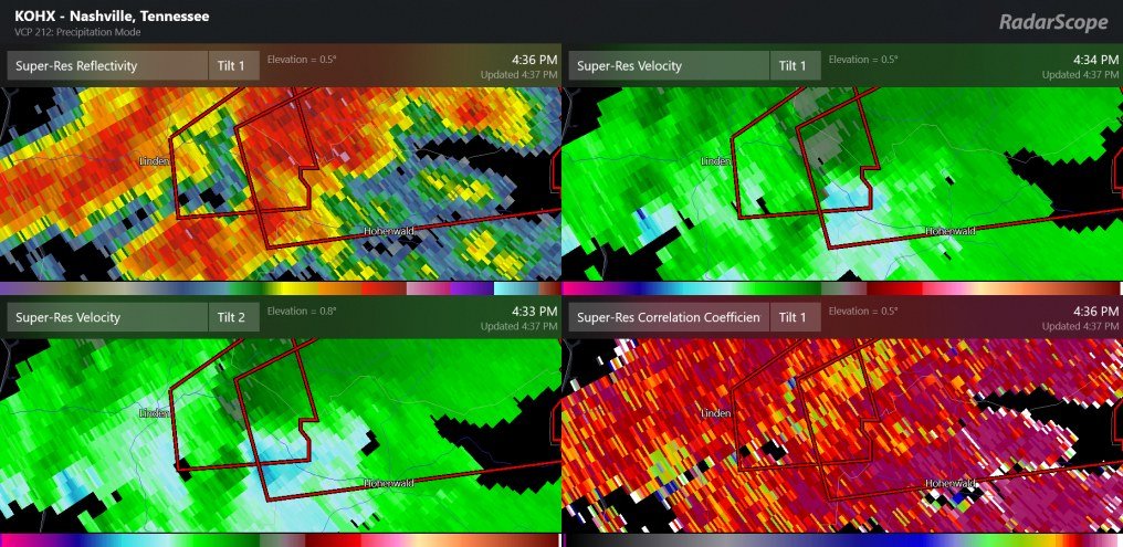
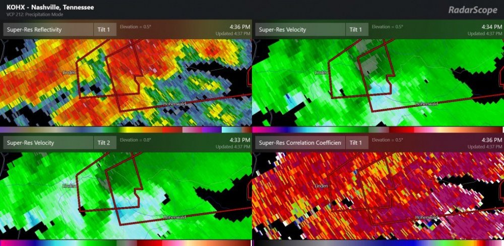
higher rotation near Hohenwald TN
-
Day-1 convective outlook has 30%/30%/10% around Memphis a part of the convective outlook (06z)
-
131 mph base velocity
-
tornado warned storm west of Junction TX
-