

roardog
-
Posts
1,228 -
Joined
-
Last visited
Content Type
Profiles
Blogs
Forums
American Weather
Media Demo
Store
Gallery
Posts posted by roardog
-
-
3 hours ago, hardypalmguy said:
You should probably insulate it better then as mine has yet to fall below 68.
There’s no way a house will stay above 68 when the air temp outside is as cool as it’s been with wind for this many days unless you’re doing something inside the house that warms it up.
-
 1
1
-
-
17 minutes ago, snowman19 said:
So much for the “huge” drop in region 1+2: CRW:
https://cyclonicwx.com/data/sst/crw_ssta_graph_nino12.png
OISST:
https://cyclonicwx.com/data/sst/ssta_graph_nino12.png
Region 3.4 warming right back up: CRW:
https://cyclonicwx.com/data/sst/crw_ssta_graph_nino34.png
OISST:
https://cyclonicwx.com/data/sst/ssta_graph_nino34.png
Region 3 is still record warm too at around +2.0CConsidering 1.2 was over +3.6 in August, I would say there's been a huge drop.
-
3
-
 1
1
-
 1
1
-
-
This is getting off topic but the recent global spike in temps has to be originating from something other than the underlying warming trend. It’s such a sudden spike. I’d bet we will eventually regress back to the mean.
-
10 minutes ago, bluewave said:
The new DJF 500 mb pattern is a blend of El Niño and -PDO composites with the trough pulled further west from the earlier forecasts. So a colder West and warmer East trend from earlier runs.
New run blended El Niño -PDO 500 mb composite
Old run was more of an El Niño dominant composite

The new run looks like it would have colder air available for the country overall even if the east is warmer.
-
1
-
-
27 minutes ago, bluewave said:
Euro seasonal update is trending colder in the West and warmer East as it has a more well defined -PDO pattern for the winter. The main feature of the -PDO is the warm pool and ridge south of the Aleutians. While the Euro doesn’t have great seasonal skill, sometimes it’s trends from run to run provide some skill.
New run

Old run

The 2M anomaly maps on the seasonal models are terrible. The cold anomalies are always way underdone for a cold pattern. For it to show such a large area of the country at normal or below for 2M temps tells me that it must have a darn cold pattern depicted for the country overall. We would need to see the 500 MB heights to see how it really looks.
-
1
-
-
Alex forecasts WAD every winter. lol
-
3
-
 1
1
-
-
4 hours ago, weatherbo said:
One good blow will chill it down quickly.
The cool and windy August caused the buoy temps in Lake Huron to fall into the upper 50s due to the wind turning over the water. Now, it’s back up to the mid 60s because of the lack of wind recently. Once we get the wind this weekend, the buoy temps on all of the Great Lakes will probably drop a good bit.
-
1
-
-
8 minutes ago, brooklynwx99 said:
PDO should rebound pretty quickly once into November / December. not expecting positive, but somewhere in the -0.75 to +0.25 range by then
I’m just curious why you think that it will rebound that much from nearly record lows? Is it because you believe the Nino will force the change or are there other things that you’re seeing which will help force the change?
It looks like the water off the west coast is cooling again starting to give it more of the classic -PDO look. -
9 hours ago, TheClimateChanger said:
Hard to argue with that when this #NotAWeatherGirl is swimming in Wisconsin in October.
We should let everyone that does the extremely hard work of putting togethet a winter forecast know that as long as this person is in their pool in October the temps the following winter will be mild. Throw everything else you thought you knew about seasonal forecasting out the window.
-
2
-
3
-
-
10 minutes ago, snowman19 said:
Region 3.4 climbing on OISSTIt is but I think Nino 4 is the most impressive all things considered. The Nino 4 anomaly is almost as high as 3.4.
-
Nino 4 up to 1.31 today. What was the highest anomaly Nino 4 had in ‘15-‘16?
-
18 minutes ago, GaWx said:
@snowman19is full of knowledge, provides a lot of useful info, and has helped make this thread as lively as anyone has. That’s all greatly appreciated. The thread wouldn’t be the same without him/her. However, there’s much room for improvement regarding objectivity imo. Then again, he/she is far from the only one with much room for improvement in this regard imo. It isn’t easy to keep one’s biases from influencing the nature of one’s posts.
I can’t disagree with anything you wrote but at the end of the day, the official CPC numbers will be what goes into the record books. So posting the warm Coral Reef Watch to prove your point is irrelevant imo. If you’re posting it just for the sake of discussion, that’s one thing but posting it to prove the Nino is heading to super status when that’s not even the source used doesn’t make any sense.
-
1
-
-
2 minutes ago, 40/70 Benchmark said:
No one doubted it would recover in short order, otherwise it would peak at moderate ONI, which no one thought was possible since early last spring.
He keeps showing Coral Reef which is warmer than OISST even though it’s as irrelevant as CDAS for the official numbers.
-
1
-
-
Who knows, maybe the MJO will do something this time but it feels like we’ve been down this road every month since Spring. It’s always the CFS or BOM that forecasts a strong MJO and it never materializes but twitter and snowman go crazy over it. Like I said, maybe it’ll be different this time.
-
2
-
1
-
-
1 hour ago, Stebo said:
Yeah I am quite surprised how much the color has changed in the last week here, we did have a few cool nights but I think more so has to do with how dry it has been recently. Trees are burning through their fuel right now.
I don’t have any evidence to back this up but I feel like the temperature in August plays a role. We had a cool August this year and I was seeing more color than usual already at the end of August. I remember in 2017 after the cool August, we had quite a bit of early color showing up until the 90F temperatures in the second half of September seemed to slow it down.
-
1
-
-
38 minutes ago, bluewave said:
Nino 3.4 back to moderate levels near +1.4 as the Niña-like lack of any appreciable WWBs continues. The much lower RONI and MEI isn’t allowing the trades to fully relax like we typically see during Ninos. So the competing influences are currently acting as brake on El Niño development.


The water along the west coast of the US is really cooling down too, going back to more of the classic -PDO look. Mixed signals everywhere right now.
-
19 minutes ago, snowman19 said:
I’ve been waiting for region 1+2 to cool into a La Niña too
lol. You keep repeating this as if this is something I said would happen. I made a comment awhile back that said the CFS was forecasting 1.2 to decrease. 1.2 has decreased. The CFS shows it between 1.0-1.5 for the winter. Although the CFS is generally an inferior model, I could see 1.2 continuing to decrease on average over the next few months.
-
1
-
-
5 minutes ago, snowman19 said:
I would not discount the +IOD either. It’s a huge elephant in the room. It isn’t just very strong, it’s record strong and that is going to dramatically alter the forcing and the global heat budget as we go into winterI’ve been waiting 5 months for the big MJO wave that’s always going to develop in a couple of weeks.
-
1
-
1
-
-
7 minutes ago, bluewave said:
I would just note that the entire area around the WPAC into the Eastern IO is much warmer than at the same time in 2019. So we can’t expect to see the same outcomes as that year. These competing marine heatwaves add a new level of complexity to the forecast patterns. So we can’t just rely on the old correlations under colder SST eras. Using just one index like Nino 3.4 or IOD exclusively in this new era just isn’t going to cut it anymore.

Some of these indexes are derived from such a small area that it doesn’t always tell the whole story.
-
18 minutes ago, snowman19 said:
This is huge, the IOD has strengthened all the way up to +1.45C, this is already ahead of where it was in 2019, which was the strongest +IOD on record. It’s late September and we are only 0.7C away from the 2019 event’s peak and it’s still projected to keep warming until November. This event is not only way overperforming but it’s very well coupled and is going to have a huge effect on the global heat budget/longwave pattern: https://x.com/ben_domensino/status/1706195455531720746?s=46&t=NChJQK9_PUjA1K7D2SMojw
https://x.com/jnmet/status/1705953345570066931?s=46&t=NChJQK9_PUjA1K7D2SMojwHonest question because I really have never paid much attention. What does a +IOD usually mean for the North American pattern?
-
16 minutes ago, bluewave said:
Looks like a head-and-shoulders pattern in the stock market.
")
https://www.schwab.com/learn/story/identifying-head-and-shoulders-patterns-stock-charts
Must be heading below the neckline now.
-
1
-
-
1 hour ago, GaWx said:
OHC back down to +0.90 per this:
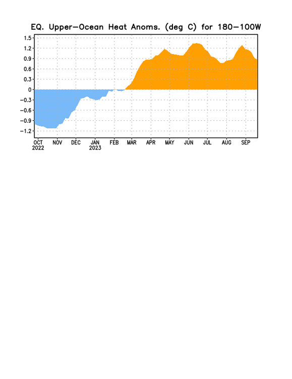
Maybe we’ve peaked?
-
1
-
1
-
-
28 minutes ago, bluewave said:
Looks like a hybrid Nino-Niña pattern to start October. We get the Niña-like Aleutians ridge and downstream ridge north of the Great Lakes. Then the El Niño influence of the height rises over NW Canada. But the typical Nino-like Aleutian Low is pretty much absent through the start of the month. So this goes to a tug of war pattern between competing influences.
EPS forecast

La Niña October +SOI composite

El Niño October composite

Or it could be that the models are confused by the competing influences and therefore the mean is depicted the way it is. I guess we would have to see individual members to determine that.
-
The winter of 13-14 was a very cold winter over here in the Midwest. I believe northern Minnesota ended up colder than 76-77. Although this was 10 years ago, I think it shows that if you get the pattern to support it, it will still get very cold. Even last winter, parts of North Dakota were several degrees below normal for the winter. That’s a bitter cold winter for an area that’s already cold on average.
The issue in recent years around here and east to where you guys are is really all about the tropical forcing. Is that due to climate change, a natural cycle or a combination of both? It makes you feel like the WPAC warm pool is due to climate change but it also wouldn’t completely surprise me if it reverses in some fashion at some point.
-
1
-


October 2023 General Discussion
in Lakes/Ohio Valley
Posted
Your house must get full sun exposure along with you cooking in it to have it that warm because regardless of how well it’s insulated, a house will not stay that warm for that long from last week’s warm weather. If you subtracted the cooking and sun, your house wouldn’t be 70-74 degrees so you really can’t compare your situation to Michsnowfreak.