

roardog
-
Posts
1,233 -
Joined
-
Last visited
Content Type
Profiles
Blogs
Forums
American Weather
Media Demo
Store
Gallery
Posts posted by roardog
-
-
I’m not sure what the true definition of Modoki El Niño is but JB uses it for any El Niño where 3.4 is warmer than 1+2. If you read what he’s saying, he says he expects 3.4 to be warmer than 1+2 during the winter. I don’t think that’s a true Modoki but he always calls it that. He’s not actually expecting 1+2 to have negative anomalies.
-
29 minutes ago, snowman19 said:
Wouldn’t we want the subsurface to at least be as warm as ‘97 or ‘15 to see the same trajectory?
-
The CFS V2 has gradually been getting cooler with the peak with it now showing a strong Nino as opposed to a super. It’s interesting that it declines 1.2 quite rapidly very soon. I wonder if we will actually see that occur.
-
 2
2
-
 1
1
-
-
33 minutes ago, snowman19 said:
Right, however, now that we have this strong El Niño event developing, coupled with a very healthy +IOD, my thinking is that this may be enough to finally break the IO and Maritime Continent MJO phases. We will have to wait and see
Why do you feel this developing El Niño will be able to when even the Super Nino in ‘15 couldn’t? What’s different this time?
-
There’s been so much summer warmth and high dewpoints in recent years that I think it’s skewed the perception of what summer can be here. Last summer felt like a somewhat cool summer to me with those stretches of comfortable temps and low dewpoints but the reality is that it wasn’t really cool at all in the end. I think our last real cool summer month was August 2017. Six years is a long time.
-
While it’s been very dry recently, the changing pattern next week looks much more favorable for rain across our sub. We don’t usually do dry very well these days around here. If anything is agw fueled, it’s the extra moisture we get around here in the summer. It seems like an eternity since dewpoints have been as low as they’ve been recently in the summer.
-
13 minutes ago, TheClimateChanger said:
I see a lot of media reporting this as "it's too late to save Arctic summer ice." I'm not so sure. I think a targeted system of solar radiation management by spraying aerosols in the atmosphere over the Arctic each summer could buy us sufficient time to draw down GHG levels. But none of our do-nothing politicians want to have that discussion!
I’m not sure intentional climate change is better than unintentional climate change.
-
I still think the -PDO is interesting. I don't think that's flipping positive anytime soon. We see hints of -PDO even on the models that have the strong/super Nino. December '72 looked nothing like a Nino across the country. Was it due to the -PDO? Even if we were to manage to achieve a very strong Nino like '97 or '15, I think there's a good chance the PDO will be very different than those two years. So, a -PDO combined with possibly more west based forcing would at least keeps things interesting I think.
-
7 minutes ago, snowman19 said:
That’s like betting on the outcome of a football game when it’s already in the 4th quarter.
-
 1
1
-
-
It looks like the MJO is going to be moving strongly through the Maritime Continent phases. Is that unusual for a developing El Niño?
-
2 minutes ago, SolidIcewx said:
I can see to my north and it looks really thick over there
It’s even causing visibility restrictions at the surface. If I had a forest nearby, I would think it’s on fire. lol
-
Canada burning is causing amazingly thick smoke here.
-
1 minute ago, hardypalmguy said:
Lake is temp of ocean off coast of San Diego. Makes sense.
The problem is as soon as you get some wind to mix it up, it'll cool down. It takes more than a couple weeks of warmth to warm up such a big, deep body of water. It's pretty deceiving really. The water temp there could easily be cooler on the 4th of July than it is now.
-
2
-
-
I’m not as knowledgeable as a lot of you guys are but it looks like the MJO could be heading back toward the Maritime Continent toward mid June. Doesn’t that usually impact the Nino development in a negative way? That probably means the global pattern would be getting a shake up as well.
-
1
-
-
51 minutes ago, snowman19 said:
Agreed. Besides the tanked SOI, look at the tweets I just posted….there’s +6C subsurface anomalies barely below the surface in regions 1+2 and 3. Not really sure where people are getting that this event is an east-based El Niño fail….the 20C isotherm is just below the surface in those regions and the warmest SSTs in the tropical Pacific are currently in ENSO regions 1+2 and 3. How some people think that’s an east-based Nino fail is beyond my comprehension. The MJO stalled in phase 7 is going to produce WWBs across the tropical PAC soonMaybe the MJO doesn’t stall in phase 7. Euro keeps it moving with a split in its members between weak phase 8 or into the circle. JMA takes it straight into the circle while Australian model takes it fairly strongly into 8 but that run was from a couple of days ago. It seems the trend has been for weaker MJO forecasts. The GEFSv12 seems to kind of be on its own here.
-
1
-
-
Anyone else remember 20+ years ago when Accuweather had videos called Point Counterpoint with Joe Bastardi and Ken Reeves. This thread reminds me of that. lol
-
It looks like the sub surface/heat content cooled a little on the weekly update.
-
1
-
-
BTW, with how negative the PDO has been, it’s no surprise it is starting to become less negative. I’m not sure that means it’s going to flip to positive soon.
-
1
-
 1
1
-
-
6 minutes ago, snowman19 said:
The flip to +PDO seems to be starting and the extreme warmth in region 1+2 is migrating west into region 3….
Now you're just getting desperate.
-
2
-
-
24 minutes ago, 40/70 Benchmark said:
Everyone run and hide before the ENSO eats us all alive
Truly frightening. lol
-
16 minutes ago, Terpeast said:
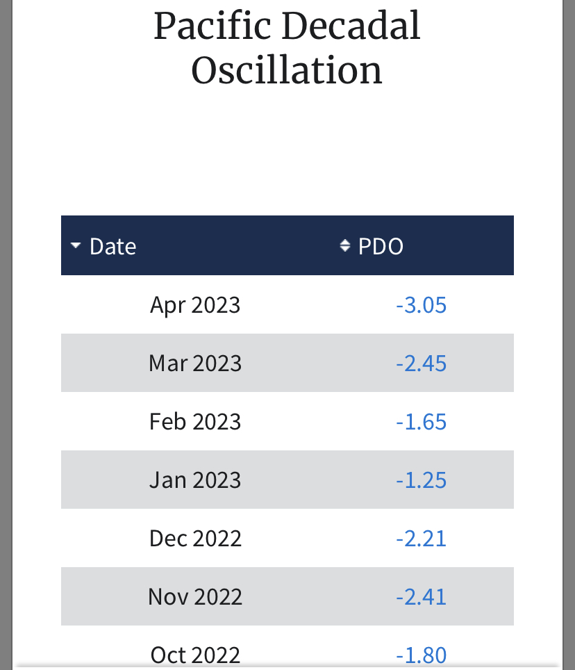
We’ll have to see how that plays out in a PDO that is currently negative 3!
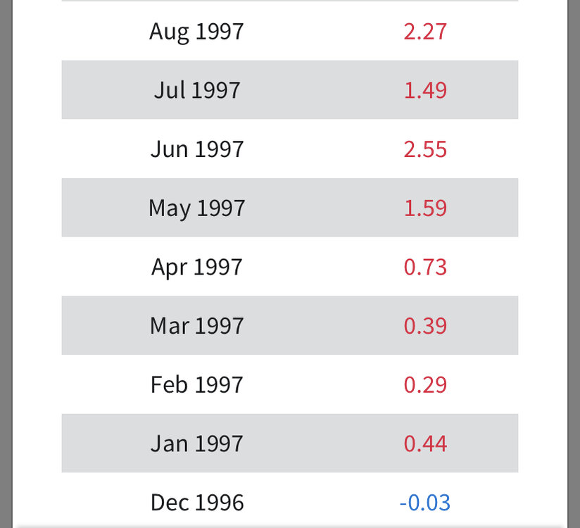
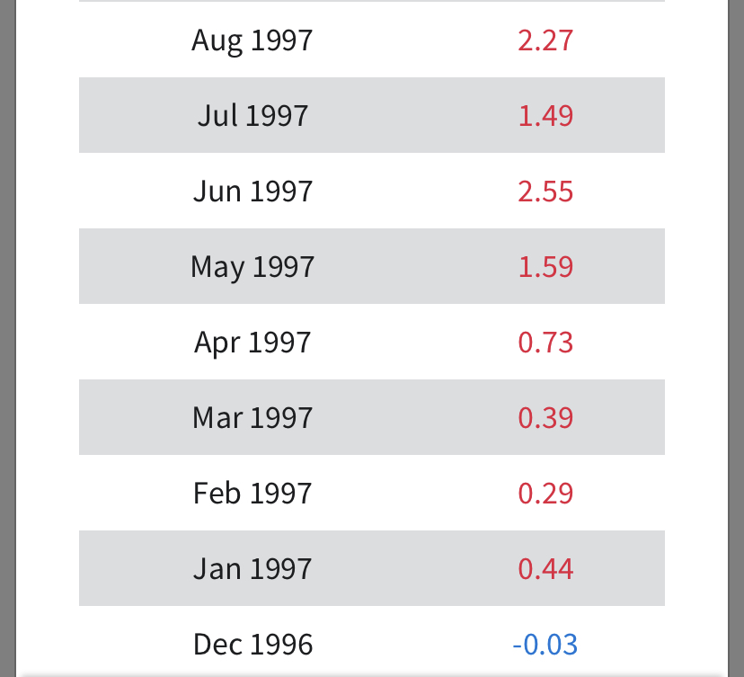
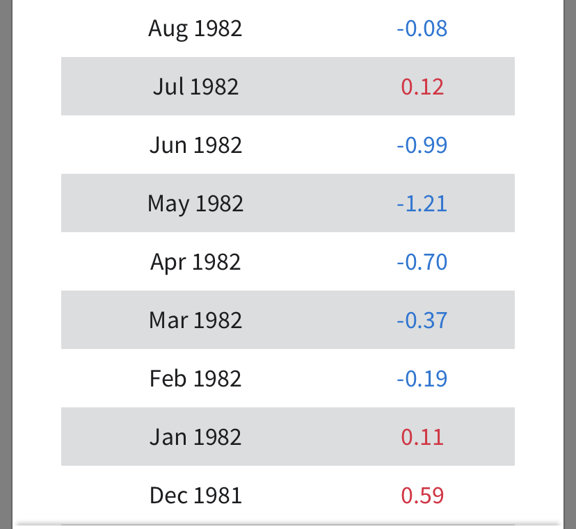
by comparison, pdo was moderate-strong positive in 1997, and neutral-weak negative in 1982


How much does it even matter if the current 3.4 anomaly is high than 1997 at this time? Nothing else that matters is anything like 1997 right now. Twitter is just used for hype apparently.
-
1 minute ago, bluewave said:
The April Central Pacific Trade wind index still came in positive. So we are closer to the El Niño years which took longer for the trades to relax.
Developing El Niño Aprilshttps://www.cpc.ncep.noaa.gov/data/indices/cpac850
850 MB TRADE WIND INDEX(175W-140W)5N 5S  CENTRAL PACIFIC
                        ANOMALY
2023….+1.1
2018…..+1.7
2015….-1.6
2014….-0.1
2009….+1.2
2006…+1.5
2004…..+1.2
2002….+0.4
1997….-1.8
1994...+0.5
1991…+0.5
1986….+0.9
1982….-1.5.
This is another index that kind of shows my point about how the super Nino years were "primed" and ready to go by this point.
-
1
-
-
I guess the sun angle didn’t stop it from accumulating.
")
-
7
-
-
Even the CFSv2 with its super Nino forecast has 1.2 peaking now and falling. Some of the members have it barely above 0 by December.
-
1
-
El Nino 2023-2024
in Weather Forecasting and Discussion
Posted
As was discussed earlier in the thread, the CFS v2 is showing an almost immediate plunge in the 1.2 anomalies. Looking at the subsurface, you wouldn’t expect that. Even though all models have flaws, there must be some reason it’s forecasting an immediate decrease even with that warm subsurface. These aren’t 1975 primitive models. lol