

roardog
-
Posts
1,588 -
Joined
-
Last visited
Content Type
Profiles
Blogs
Forums
American Weather
Media Demo
Store
Gallery
Posts posted by roardog
-
-
32 minutes ago, michsnowfreak said:
Agree on all counts. Its like inappropriate touching to the fanatics to point out cold/snow extremes. No one is denying climate change, but the Great Lakes/Midwest is a region with cold winters/hot summers, so most winters, no matter how "warm" they are in the mean, will have some cold/snow stories to be had. And quite honestly, back to the graph chinook posted, I am quite surprised what a bout of deep winter this region saw for a strong Nino. I knew we would have cold shots and snow while some were on a ledge in December, but did not foresee a blast like that. Hoping some more fun is had in Feb/Mar.
So much of the season to go, but year-to-year rubber-band snaps can be wild. Locally, there were insane ones from 1880-81 to 1881-82, 1917-18 to 1918-19, and 1981-82 to 1982-83. But the 5 year period from 1877-1882 was downright wild.
1877-78: warm
1878-79: cold
1879-80: warm
1880-81: cold
1881-82: warm
No. Those winters were all cold. The warm ones you listed were due to rooftop temperatures. lol
-
 2
2
-
-
5 minutes ago, TheClimateChanger said:
There were 6 counterexamples in the FOUR decades from the 1960s-1990s - that is pretty much every single year, as I claimed. Older data is worthless for this comparison, since it was collected 400-500 feet lower in elevation on a rooftop in the middle of the city.
This isn’t the forum for this but lol seriously.
-
1
-
-
7 minutes ago, snowsucks said:
you know you love to see it. early spring greenup this year.Yes. It’s going to green up in early Feb in Milwaukee.
-
 1
1
-
1
-
-
1 hour ago, Spartman said:
I think it means you’ll get a lot of 89 degree highs this year. Just kidding.
-
1
-
 1
1
-
1
-
-
1 minute ago, cyclone77 said:
Another 0.5" yesterday and overnight, which brings us to 19.9" in the past 6 days. Last season the whole seasonal total was a bit over 22", so we've nearly matched that in just 6 days lol.
MLI has had nearly 26" in the past 6 days. Officially 16" OTG there and also at DVN. Prob 13 inches or so here.
I guess you better hope for a super Nino in the future instead of La Niña. lol
-
2
-
-
8 minutes ago, Stebo said:
An emoji of a man shrugging. Honestly its so changeable that I don't know what may happen. We need to keep the temp down though before precip falls otherwise we may be in the same situation as last event.
The 12Z Nam does look slightly east again FWIW which may not be much but a few miles matter for us on the eastern side of the state, especially you guys down there.
-
2
-
-
Pray for the palms.
-
11
-
-
I think if Feb were to end up cold and dry, Michsnowfreak would still be happy as there will always be some snow around if it’s cold and any snow cover would stick around.
-
1 minute ago, OrdIowPitMsp said:
He can keep creating new usernames all he wants. It seems banning him set the stage for an active period in the region, we can play this game again in 4-6 weeks.
Hope the weight of the heavy snow doesn’t crush his palms. lol
-
1
-
-
2 minutes ago, michsnowfreak said:
Translation from Mr Richman
"Be careful of clickbait on social media that outlines reasons why a step down process and turn towards colder, more wintry weather is likely coming up in January and beyond. Instead, listen to my advice, which includes no reasoning and just a blanket statement that a strong el nino means cold stays to the northwest (which is not even correct)".
Yeah. cold staying northwest is La Nina. That was the pattern last winter. lol. So much misinformation everywhere these days.
-
1
-
1
-
-
3 minutes ago, snowman19 said:
I don’t think it’s substantial warming, but probably enough to get above +2.1C on the weeklies within the next 2 weeklies, then a slow decline


I'm not sure it's going to quite make the super tri monthly but it won't be too far off. Good job staying with your prediction even when things weren't looking great. Super Nina and extreme -PDO next year?
")
-
1
-
 1
1
-
-
5 minutes ago, michsnowfreak said:
Did I ever say climate change was not taking place?
 It always kills me that whenever a joke of a story is mocked it means the person mocking it doesn't believe in climate change. Hell a troll can say something like "the climate will warm 30° in 2 decades" and people calling bs will be told they dont believe in climate change. The whole point is the inability to separate weather events from climate in the mainstream is ridiculous.
I swear critical thinking goes out the window when climate changed is involved. It just becomes emotionally or politically driven.
-
1
-
1
-
-
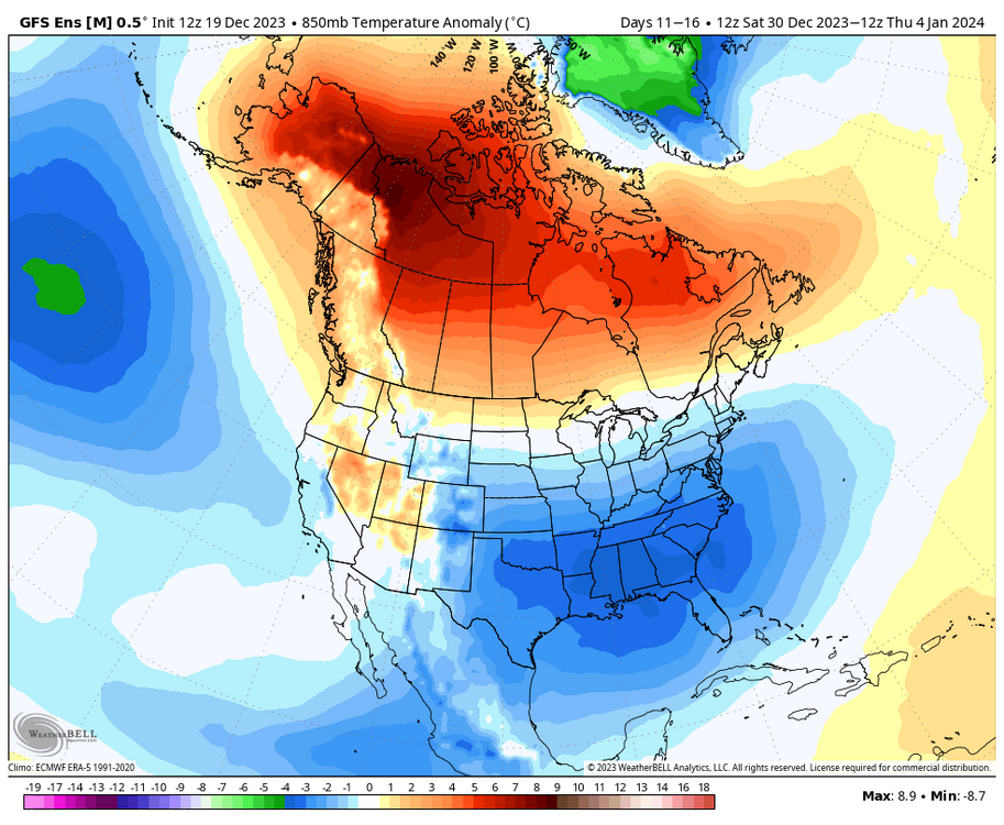
A lot of the El Niño winters that you guys on the east coast love had this pattern in December. Maybe it’s a little warmer than December 1965 for instance since the planet is warmer overall but the general idea with the warmest anomalies being across the north(especially northern plains) is pretty classic Nino December. Your ‘02/‘09 cold Nino Decembers are pretty rare especially for a Nino that’s technically almost super.
-
2
-
-
I think some people fail to realize how quickly Canada can cool down this time of year. North America being flooded with pacific air and that big ridge sitting in southern Canada means very mild temperatures in a lot of the country.
Look what happens later next week though when the ridge moves into NW Canada. We already have colder air moving south into eastern Canada at that time which then moves south into the eastern half of the US. It might not be anything unusual but it will bring well below freezing 850 temps and below freezing high temperatures to much of the Great Lakes and New England. Some people here act like it won’t snow all winter because it’s ridiculously mild in Edmonton right now.
-
1
-
3
-
-
I’ve grown to not be a big fan of extreme cold because it’s usually otherwise quite boring but palm dude’s posting is making me hope for a January 2019 style cold outbreak. lol
-
3
-
1
-
4
-
-
17 minutes ago, andyhb said:
How has that guy not been banned yet...
He has been at least once under previous names. lol
-
1
-
-
30 minutes ago, michsnowfreak said:
Oh I definitely think Feb is the best month of winter this year, as has been the case often recently. I think too many are confusing a change around new years as meaning arctic cold. No one is saying that. Just get me a more seasonable pattern and im happy. You and I EASILY can get snow in above avg patterns. The midatlantic usually needs some cold, which looks like they may have some colder anomalies. It basically increases snow chances for all while waiting for a deep winter pattern.
Looking at the models, they seem to be honing in on a change to much colder by late next week at least for the Great Lakes area and east. Most of Canada stays very mild but as the big ridge moves more into central and northwestern Canada, it allows colder air to move into eastern Canada and down into our area. It won’t be anything to write home about but 850 temps even a little below normal around here in late December is quite cold and huge change from what we’ve experienced most of this month.
-
1
-
1
-
-
12 minutes ago, brooklynwx99 said:
the source region drastically improves, though. instead of a Pacific onslaught, you're getting air out of AK / northern Canada and split flow underneath. it's a completely different pattern
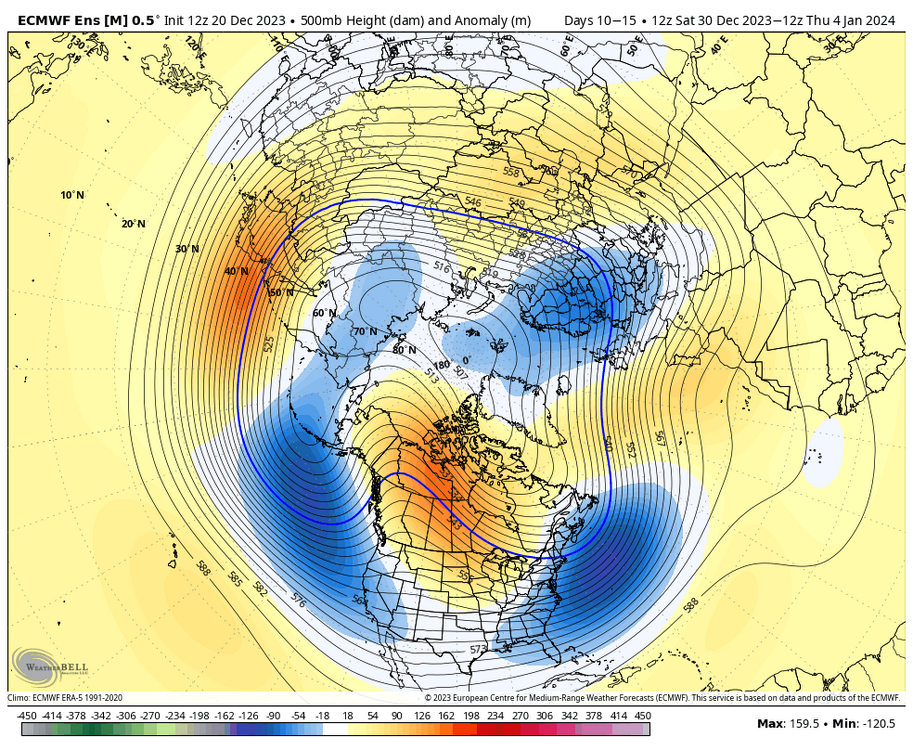
Anyone who can’t see the difference in the pattern across North America on this map compared to what it is now is just trolling or blind. Even average temperatures in early January are cold over here and in New England.
-
3
-
-
41 minutes ago, 40/70 Benchmark said:
The forcing from el Nino is so far west that it actually bolstered the warm December idea.
Yeah. It seems the East based Ninos with the more eastern forcing actually have colder Decembers. 1997 had some cold around during December. Although much weaker, 1976 of course was a very cold December that turned “warm” in February. That’s opposite of what you see a lot of times with the more western forcing.
-
2
-
-
1 hour ago, Lightning said:
I know what you mean. I figure I eventually will have to pay one of the neighbor kids to do my driveway but I have several years to go before that happens (

 ).
).
Last year I had the biggest mostly sleet (mixed with a little ice) event I have personally seen (while just to my south was getting a major ice storm). Boy that was a bugger to clean off the driveway.
I think the most sleet I’ve ever seen was early April 2003. The previous night was an ice storm while everyone to the south was getting just rain. The next night everyone to the south was getting an ice storm while I was getting buried in sleet. I remember there was at least two or three inches of sleet. It stuck around for a while too even though it was April.
‘83,’03,’07,’16 were all Ninos that had a real wintry period in early April. Will ‘24 join that list?
-
1
-
-
27 minutes ago, brooklynwx99 said:
also, a warm Canada doesn't mean that it can't be cold here. it's a silly argument. +10 up there can be -5 down here... the GEFS shows that well. this is often the case in El Nino winters. Feb 2010 is actually a glaring example. Canada was absolutely blowtorched and BWI got 50" that month
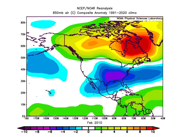
Maybe my memory is wrong but wasn’t 09-10 the warmest winter on record for Canada?
-
2 minutes ago, snowman19 said:
The current equatorial SOI that @griteater posted the other day, shows that this event is extremely robust and a top tier El Niño, right up there with 72-73, 82-83, 97-98 and 15-16
Yes but the “old” SOI formula doesn’t show that so it’s just more conflicting Enso signals that we’ve become accustomed to with this event.
-
The 30 day SOI is at -2.78 now which is kind of crazy for a strong Nino.
-
1
-
-
6 hours ago, weatherbo said:
Blustery with snow showers today... right around 2 inches otg, however it won't last. Forecast for Thursday is 46 and 41 Friday with rain.
Doesn't happen all that often, especially in the UP snowbelts but it looks like a brown Christmas this year. Here's some stats for Marquette.
.thumb.jpg.efc41b7a653749ead33953de2aeb4d34.jpg)
The scariest part of that chart is that it looks like Marquette didn’t exist in 2014 at Christmas.
-
5
-


.jpg.6307310f12c7a4d0ea44f0cbf06b81a0.jpg)
El Nino 2023-2024
in Weather Forecasting and Discussion
Posted
I wonder if we are heading toward a very strong Nina with atmosphere kind of already being in a Nina base state.