

roardog
-
Posts
1,228 -
Joined
-
Last visited
Content Type
Profiles
Blogs
Forums
American Weather
Media Demo
Store
Gallery
Posts posted by roardog
-
-
3 minutes ago, snowman19 said:
I don’t think it’s substantial warming, but probably enough to get above +2.1C on the weeklies within the next 2 weeklies, then a slow decline


I'm not sure it's going to quite make the super tri monthly but it won't be too far off. Good job staying with your prediction even when things weren't looking great. Super Nina and extreme -PDO next year?
")
-
 1
1
-
 1
1
-
-
5 minutes ago, michsnowfreak said:
Did I ever say climate change was not taking place?
 It always kills me that whenever a joke of a story is mocked it means the person mocking it doesn't believe in climate change. Hell a troll can say something like "the climate will warm 30° in 2 decades" and people calling bs will be told they dont believe in climate change. The whole point is the inability to separate weather events from climate in the mainstream is ridiculous.
I swear critical thinking goes out the window when climate changed is involved. It just becomes emotionally or politically driven.
-
1
-
 1
1
-
-
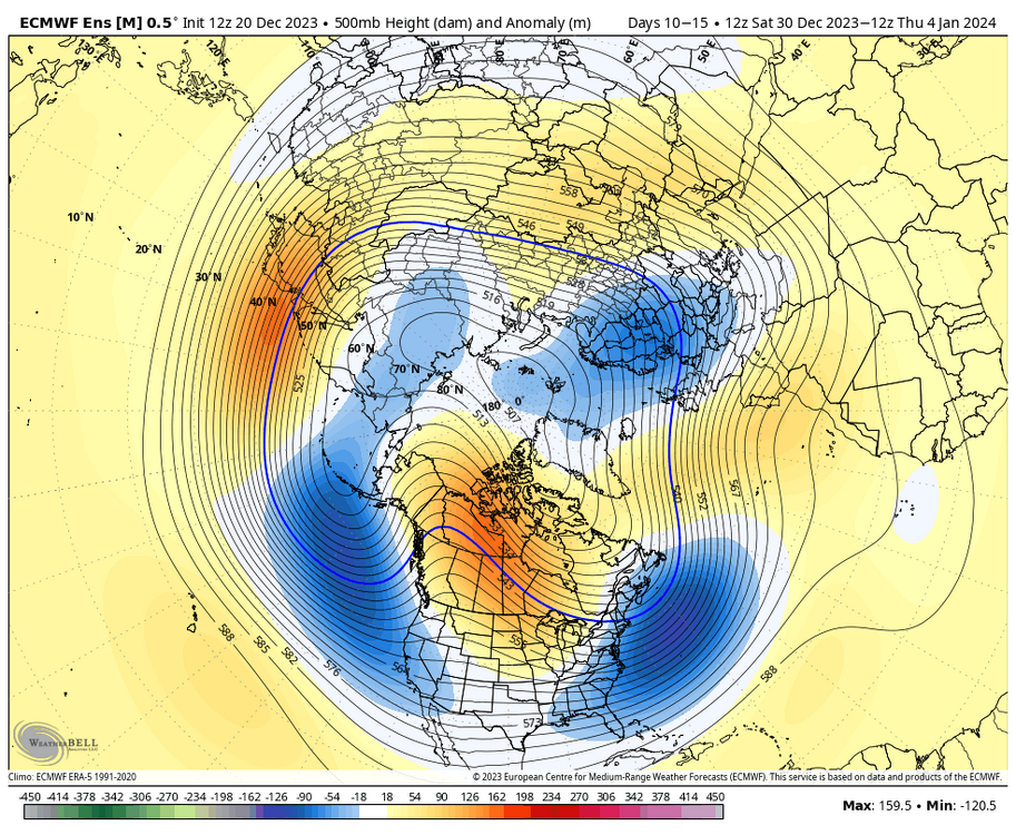
A lot of the El Niño winters that you guys on the east coast love had this pattern in December. Maybe it’s a little warmer than December 1965 for instance since the planet is warmer overall but the general idea with the warmest anomalies being across the north(especially northern plains) is pretty classic Nino December. Your ‘02/‘09 cold Nino Decembers are pretty rare especially for a Nino that’s technically almost super.
-
2
-
-
I think some people fail to realize how quickly Canada can cool down this time of year. North America being flooded with pacific air and that big ridge sitting in southern Canada means very mild temperatures in a lot of the country.
Look what happens later next week though when the ridge moves into NW Canada. We already have colder air moving south into eastern Canada at that time which then moves south into the eastern half of the US. It might not be anything unusual but it will bring well below freezing 850 temps and below freezing high temperatures to much of the Great Lakes and New England. Some people here act like it won’t snow all winter because it’s ridiculously mild in Edmonton right now.
-
1
-
3
-
-
I’ve grown to not be a big fan of extreme cold because it’s usually otherwise quite boring but palm dude’s posting is making me hope for a January 2019 style cold outbreak. lol
-
3
-
1
-
 4
4
-
-
17 minutes ago, andyhb said:
How has that guy not been banned yet...
He has been at least once under previous names. lol
-
1
-
-
30 minutes ago, michsnowfreak said:
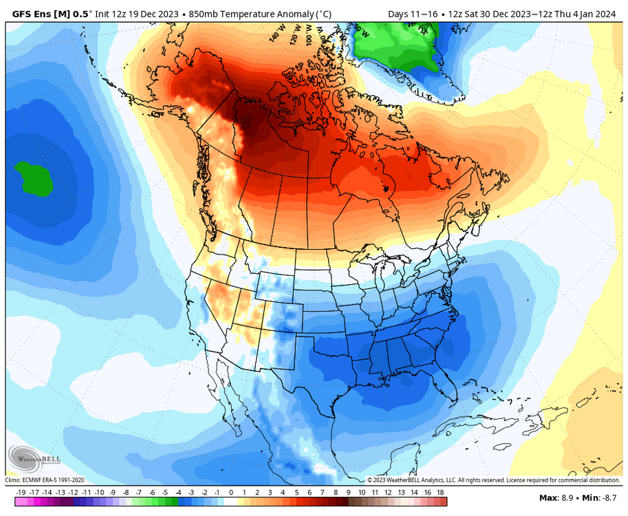
Oh I definitely think Feb is the best month of winter this year, as has been the case often recently. I think too many are confusing a change around new years as meaning arctic cold. No one is saying that. Just get me a more seasonable pattern and im happy. You and I EASILY can get snow in above avg patterns. The midatlantic usually needs some cold, which looks like they may have some colder anomalies. It basically increases snow chances for all while waiting for a deep winter pattern.
Looking at the models, they seem to be honing in on a change to much colder by late next week at least for the Great Lakes area and east. Most of Canada stays very mild but as the big ridge moves more into central and northwestern Canada, it allows colder air to move into eastern Canada and down into our area. It won’t be anything to write home about but 850 temps even a little below normal around here in late December is quite cold and huge change from what we’ve experienced most of this month.
-
1
-
1
-
-
12 minutes ago, brooklynwx99 said:
the source region drastically improves, though. instead of a Pacific onslaught, you're getting air out of AK / northern Canada and split flow underneath. it's a completely different pattern
Anyone who can’t see the difference in the pattern across North America on this map compared to what it is now is just trolling or blind. Even average temperatures in early January are cold over here and in New England.
-
3
-
-
41 minutes ago, 40/70 Benchmark said:
The forcing from el Nino is so far west that it actually bolstered the warm December idea.
Yeah. It seems the East based Ninos with the more eastern forcing actually have colder Decembers. 1997 had some cold around during December. Although much weaker, 1976 of course was a very cold December that turned “warm” in February. That’s opposite of what you see a lot of times with the more western forcing.
-
2
-
-
1 hour ago, Lightning said:
I know what you mean. I figure I eventually will have to pay one of the neighbor kids to do my driveway but I have several years to go before that happens (

 ).
).
Last year I had the biggest mostly sleet (mixed with a little ice) event I have personally seen (while just to my south was getting a major ice storm). Boy that was a bugger to clean off the driveway.
I think the most sleet I’ve ever seen was early April 2003. The previous night was an ice storm while everyone to the south was getting just rain. The next night everyone to the south was getting an ice storm while I was getting buried in sleet. I remember there was at least two or three inches of sleet. It stuck around for a while too even though it was April.
‘83,’03,’07,’16 were all Ninos that had a real wintry period in early April. Will ‘24 join that list?
-
1
-
-
27 minutes ago, brooklynwx99 said:
also, a warm Canada doesn't mean that it can't be cold here. it's a silly argument. +10 up there can be -5 down here... the GEFS shows that well. this is often the case in El Nino winters. Feb 2010 is actually a glaring example. Canada was absolutely blowtorched and BWI got 50" that month
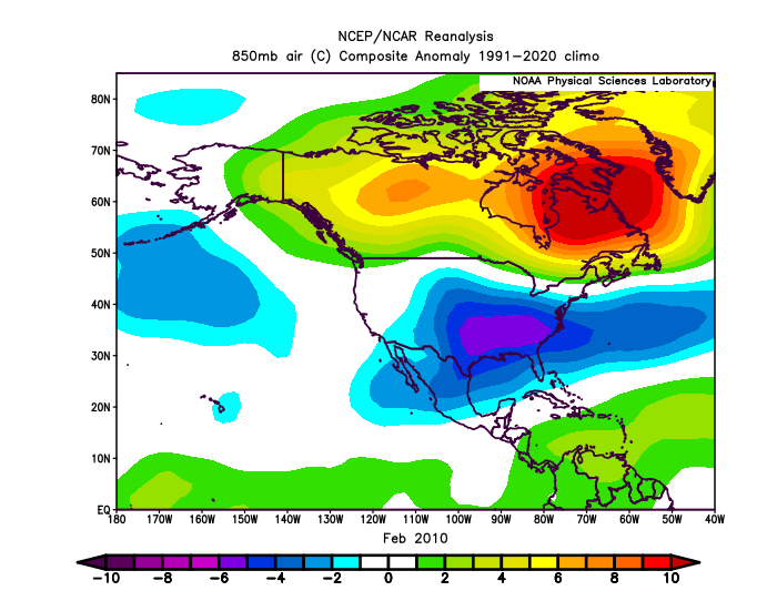
Maybe my memory is wrong but wasn’t 09-10 the warmest winter on record for Canada?
-
2 minutes ago, snowman19 said:
The current equatorial SOI that @griteater posted the other day, shows that this event is extremely robust and a top tier El Niño, right up there with 72-73, 82-83, 97-98 and 15-16
Yes but the “old” SOI formula doesn’t show that so it’s just more conflicting Enso signals that we’ve become accustomed to with this event.
-
The 30 day SOI is at -2.78 now which is kind of crazy for a strong Nino.
-
1
-
-
6 hours ago, weatherbo said:
Blustery with snow showers today... right around 2 inches otg, however it won't last. Forecast for Thursday is 46 and 41 Friday with rain.
Doesn't happen all that often, especially in the UP snowbelts but it looks like a brown Christmas this year. Here's some stats for Marquette.
.thumb.jpg.efc41b7a653749ead33953de2aeb4d34.jpg)
The scariest part of that chart is that it looks like Marquette didn’t exist in 2014 at Christmas.
-
5
-
-
47 minutes ago, MJO812 said:
Weeklies punt January
Pretty much the entire lower 48 is at or below normal 850 temps from about day 22 until the end. I’m not sure how that’s punting January.
-
It seems like the models used to mostly under develop storms. This used to show itself in the form of the well known nw trend that seemed prevalent as recently as about 10 years ago. Now, it seems to have gone completely opposite. Is this due to attempts to fix that particular issue with models?
-
4
-
-
Nothing is guaranteed in weather but a mild December in this region during an El Nino is pretty close to it.
-
1
-
-
1 hour ago, snowman19 said:
Looks like a really strong MJO wave push into phase 7 right around mid-month. That’s when it constructively interferes and the typical El Niño convection should start firing on the equator along and east of the dateline in a big way. The models are showing a beast of a WWB (which should trigger another DWKW) developing around the same time, this almost certainly results in a substantial warming of region 3.4. We go strongly +AAM as well.
Good point about the jet…it’s screaming already. The STJ may prove to be a problem this winter, that’s the key element to watch…if we have a raging, firehose STJ blasting into the west coast, it’s going to flood PAC air into the CONUS and Canada and no amount of -AO/-NAO will help that. The arctic/Atlantic blocking would just trap maritime PAC air underneath. It would also prove problematic for +PNA….it would just crash right into the +PNA ridge pops, deamplify them and knock them right back down. Bottom line, if you want a cold pattern, pray that the STJ isn’t raging.
Also, looks like all the arctic air is going to be on the other side of the pole in Eurasia going into late monthYou’ve been typing the same thing for 8 months and although 3.4 has obviously warmed, the atmosphere seems to continue to struggle to act like a strong Nino. I know you’re going to say it’s going start any day now but I remain skeptical.
-
3
-
1
-
1
-
-
Maybe with the help of El Nino, we can get some +PNA induced real clippers for a change which we haven't had in 125 years or so(maybe an exaggeration).
-
1
-
1
-
-
If the AAM is going to go positive at the end of the first week of December, how long does that even take to start to change the northern hemisphere pattern if it even does? I thought most posters here wanted a Nino response on the Pacific side. I get that Snowman is trying to get people worried about a warm December because that’s what he does but considering most posters here don’t want a Nina like Pacific, I’m not sure what the problem is. lol
-
1
-
-
10 minutes ago, CoastalWx said:
Not necessarily the forecasts itself, but look at the wording lol. I hate those.
1-3 inches of snow coming from rain possibly mixed with snow becoming all rain after 4AM. I would expect basically just rain from that forecast but somehow you can manage 3 inches of snow out of rain. lol
-
1
-
-
2 hours ago, WestMichigan said:
Apple trees still have green leaves in my backyard as well as the Bradford pears. Maples are brown but still hanging on o e tree. Oaks haven’t dropped yet either.
Palm Guy better move across the lake to your neighborhood.
-
2
-
-
10 minutes ago, GaWx said:
For the first time in 8 days, OISST updated at cyclonicwx. On the prior update, it was at +1.64 as of Nov 8th, which turned out to be a short term low just like the WCS short term low of Nov 7th. Its latest (Nov 16th) is a little cooler than WCS’ latest with +1.81 vs +1.89. Its high was +1.83, which was set yesterday.
Looking back at the last few months in 3.4, WCS has tended to be very slightly warmer (~0.05 on average) than cyclonicwx although the latest is .08 warmer.

It’s nice to have it updated. 1+2 is the lowest it’s been in a long time at +2.0. Region 4 is scorching again at +1.49. Region 4 being that warm probably isn’t good news for most on the board if the +IOD continues to weaken as I assume that would start to favor some unfavorable MJO phases.
-
1
-
-
3 minutes ago, stadiumwave said:
Just wait until that next WWB! It'll hit 3.0 in all regions except 4.

We should start a betting thread on what date the flip will occur to give up on Nino and start talking about the Super Nina and record breaking SE ridge for next winter. lol
-
1
-


.jpg.6307310f12c7a4d0ea44f0cbf06b81a0.jpg)
Winter 2023/24 Medium/Long Range Discussion
in Lakes/Ohio Valley
Posted
Yeah. cold staying northwest is La Nina. That was the pattern last winter. lol. So much misinformation everywhere these days.