WVclimo
-
Posts
5,480 -
Joined
-
Last visited
Content Type
Profiles
Blogs
Forums
American Weather
Media Demo
Store
Gallery
Everything posted by WVclimo
-
Jan 24-26 Weekend Snow and Sleetfest Model Thread Part Tres
WVclimo replied to H2O's topic in Mid Atlantic
4° with a DP of -11 wind chill of -9 -
Jan 24-26 Weekend Snow and Sleetfest Model Thread Part Tres
WVclimo replied to H2O's topic in Mid Atlantic
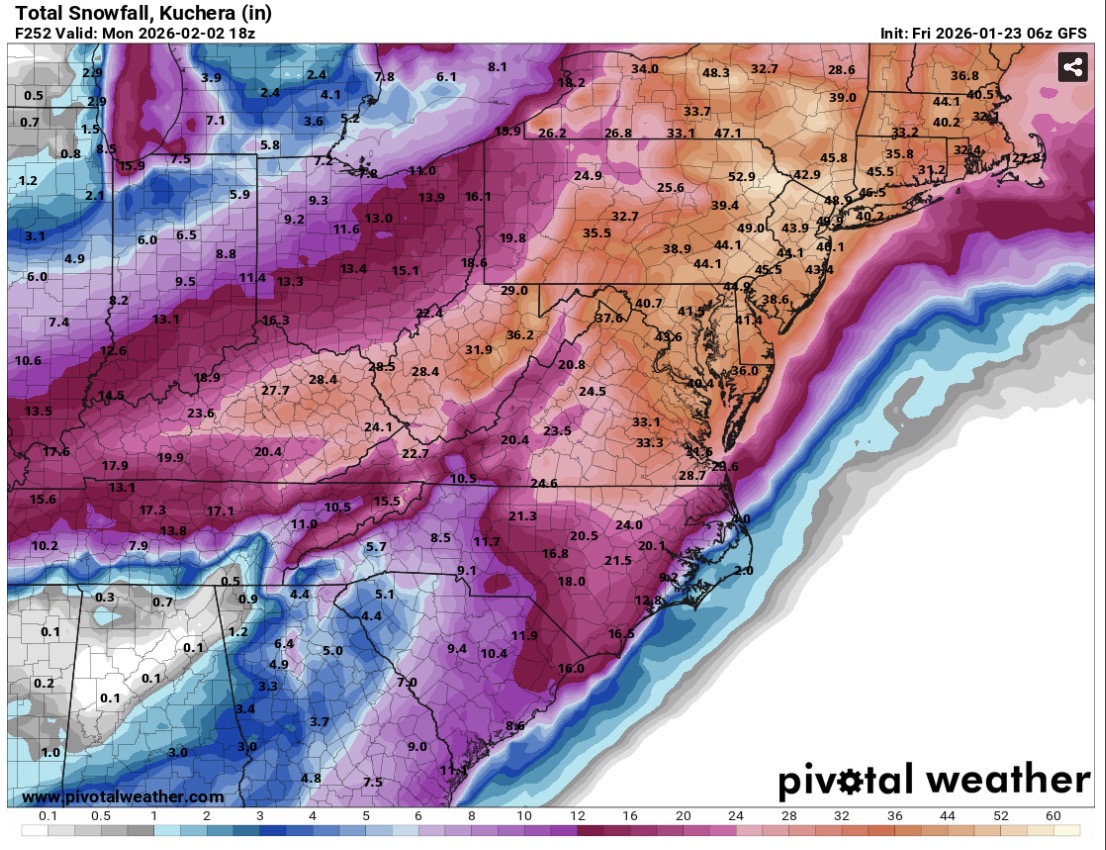
Make that 9 runs in a row for the GFS. -
Jan 24-26 Weekend Snow and Sleetfest Model Thread Part Tres
WVclimo replied to H2O's topic in Mid Atlantic
25/2 with NW wind gusting to 30. Wind chill is +10. Will probably lose another 20 degrees by morning. -
Jan 24-26 Weekend Snow and Sleetfest Model Thread Part Tres
WVclimo replied to H2O's topic in Mid Atlantic
-
Jan 24-26 Weekend Snow and Sleetfest Model Thread Part Tres
WVclimo replied to H2O's topic in Mid Atlantic
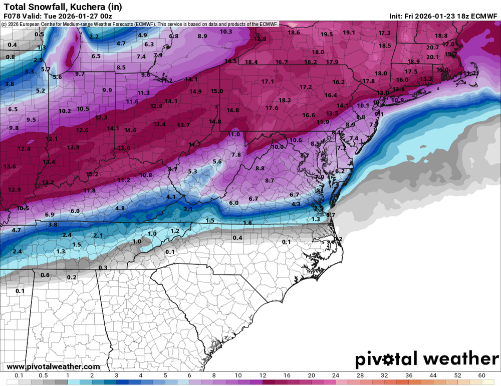
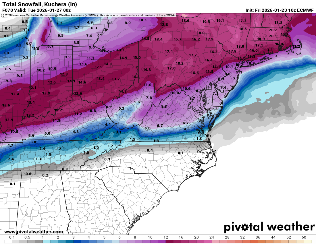
I think that's now the 8th run in a row of the GFS showing 18"+ (Kuchera) for the eastern panhandle of WV -
That low just crawls up the coast.
-
I ended up with several inches of sleet here from this one on top of 3" of snow. https://www.raymondcmartinjr.com/weather/2007/14-Feb-07-SurfaceMaps.html
-
January 24-26: Miracle or Mirage JV/Banter Thread!
WVclimo replied to SnowenOutThere's topic in Mid Atlantic
Mine is good for 3 feet, but there’s room for more if needed. The solar light on top was an addition this year. Good for seeing depth at night from the window.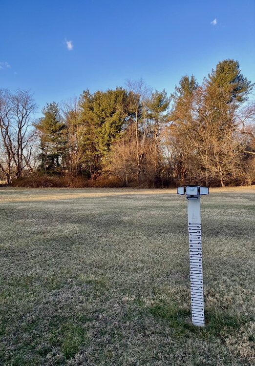
-
-
Money shot
-
Low of 5° so far
-
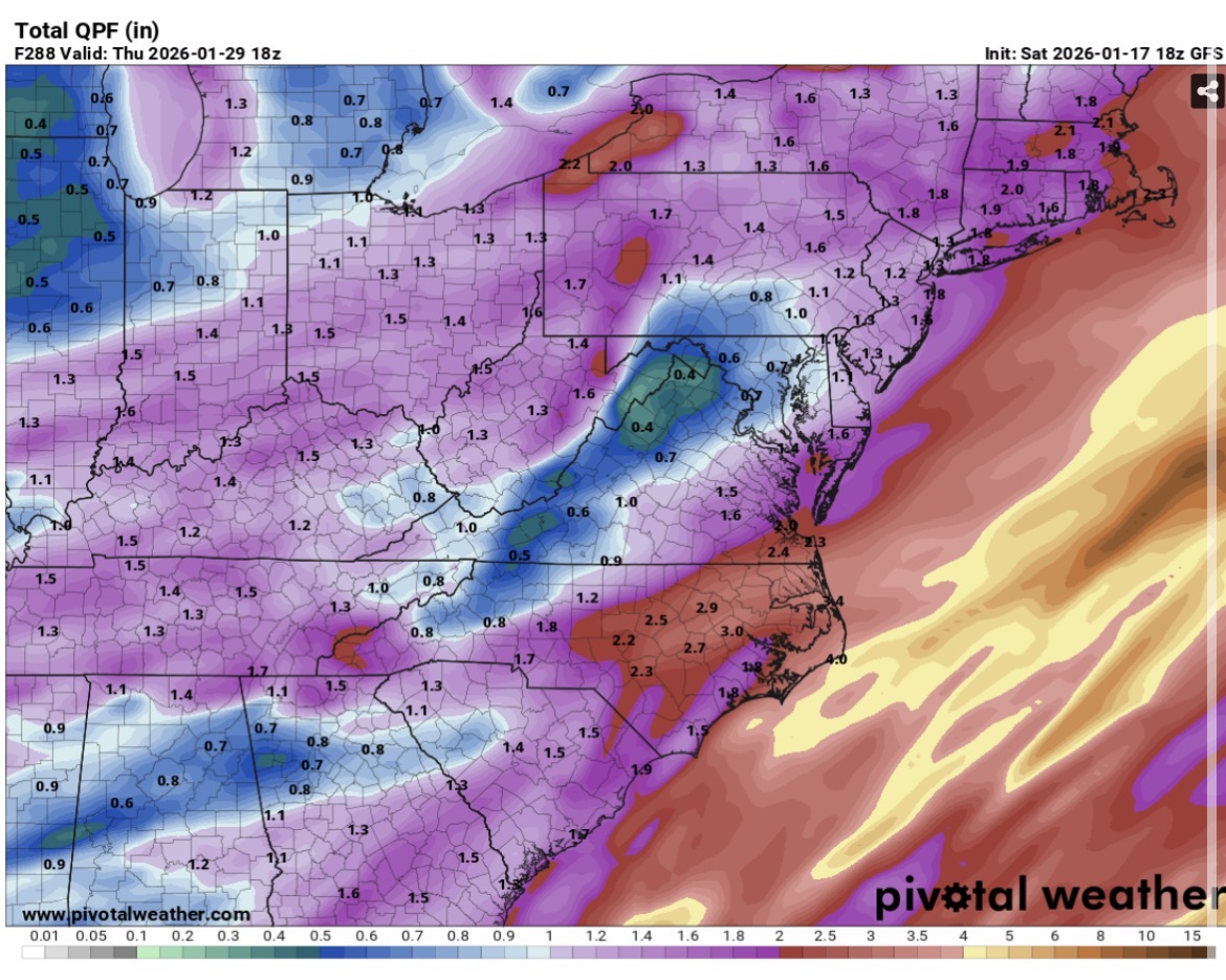
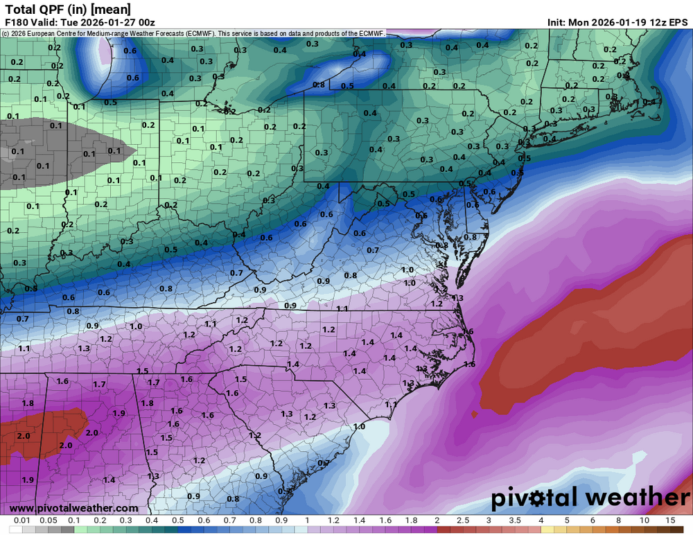
The 6Z GFS is beautiful. All snow for the area. Sleet line barely makes it as far north as Fredericksburg and the lower eastern shore.
-
High of 25. Good weather for fire concerns. 22% RH and west wind gusting to 23.
-
Low of 12 degrees
-
I am excited about a potential 4-8er.
-
Pretty good agreement
.thumb.png.38c5f394223252acb9edf173706a57f5.png)
-
Old school would have meant the Bears taking the field goals a few times rather than the 4th down attempts that ended good drives with nothing. Those points would have been the difference.
-
Snow has ended. 0.1” Fourth “measurable” snow of the season. All in the pre-dawn hours.
-
No nickels or dimes.. only pennies 12/2 - 0.7” 12/14- 0.4” 1/1 - 0.3” 1/18- 0.1” total- 1.5”
-
Light snow. All non-paved surfaces are covered. 32°.
-
18Z GFS through Day 12.

-
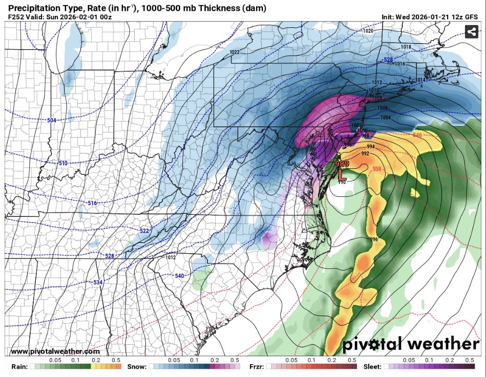
GFS says surface temps here are 12 degrees when the precip begins. Then 1.5" of QPF falls before temps rise above 20 degrees. Acceptable. Edited: also has -16F here the morning of the 28th.
-
Had a few flakes/ snow grains earlier. But radar returns now are just east of me.
-
25° with flurries. Winds NW 15 gusting to 26.


.png.bcf6f52555a38a0861a2e7cee53c4b3c.png)