dryslot
-
Posts
62,800 -
Joined
-
Last visited
Content Type
Profiles
Blogs
Forums
American Weather
Media Demo
Store
Gallery
Everything posted by dryslot
-
Where's yours?
-
This, Once we hit March, Days are numbered on the snow pack now, So ready to move on, Sure we can still get snow, But it will have little use.
-
Less people staying up for it.................
-
I think this may be the last chance to ride this week, Next week will start the pack decimation process.
-
Trace
-
Looks like its snow here.
-

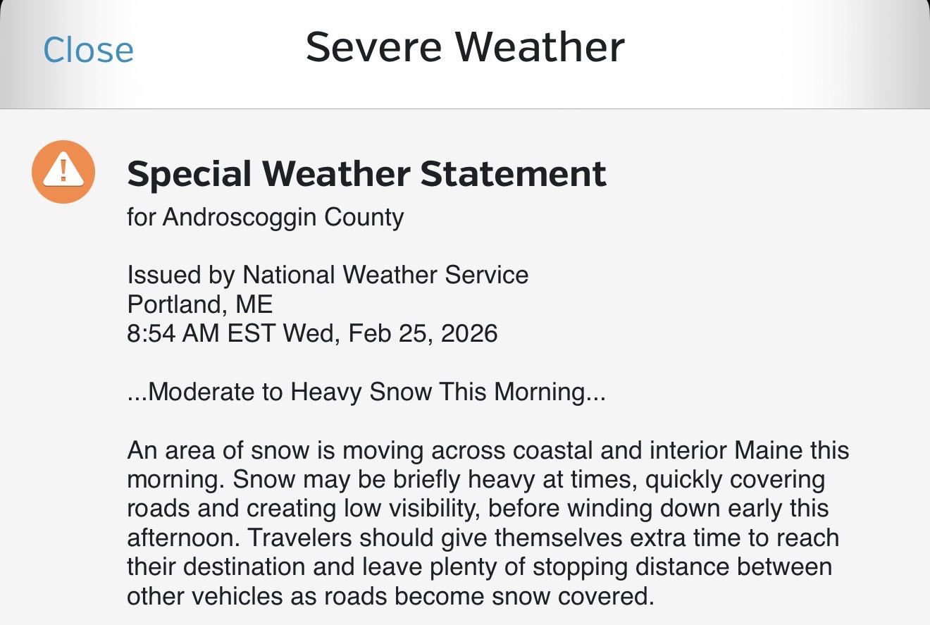
Clipper Fires In Wednesday Feb 25 Disco/ Obs
dryslot replied to Damage In Tolland's topic in New England
2.2" total. -
Clipper Fires In Wednesday Feb 25 Disco/ Obs
dryslot replied to Damage In Tolland's topic in New England
Looks like 2.2" will do it here. -
Clipper Fires In Wednesday Feb 25 Disco/ Obs
dryslot replied to Damage In Tolland's topic in New England
You will know if he says he's cancelling weather. -
Clipper Fires In Wednesday Feb 25 Disco/ Obs
dryslot replied to Damage In Tolland's topic in New England
Starting to see a bit of enhancement, Radar back building over to the west in NH here which was modeled quite well, Should end up around 3" or so, My call was 2-4".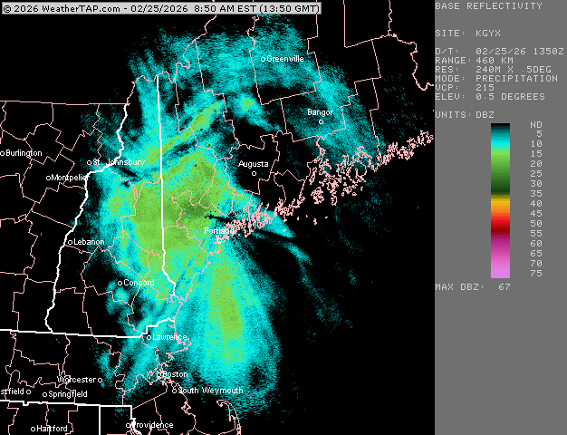
-
Clipper Fires In Wednesday Feb 25 Disco/ Obs
dryslot replied to Damage In Tolland's topic in New England
Definitely, I looked at 12z and said where did it go? -
Clipper Fires In Wednesday Feb 25 Disco/ Obs
dryslot replied to Damage In Tolland's topic in New England
You had to use the 06z runs. -
Clipper Fires In Wednesday Feb 25 Disco/ Obs
dryslot replied to Damage In Tolland's topic in New England
Don't know why anyone uses the HRRR model, Might as well use the SREFS. -
Clipper Fires In Wednesday Feb 25 Disco/ Obs
dryslot replied to Damage In Tolland's topic in New England
Now snow goggles
-
Clipper Fires In Wednesday Feb 25 Disco/ Obs
dryslot replied to Damage In Tolland's topic in New England
Sun was out 15 mins ago, -
Clipper Fires In Wednesday Feb 25 Disco/ Obs
dryslot replied to Damage In Tolland's topic in New England
2-4" -
"Don’t do it" 2026 Blizzard obs, updates and pictures.
dryslot replied to Ginx snewx's topic in New England
36" here, That's my all time and won't see that again. -
"Don’t do it" 2026 Blizzard obs, updates and pictures.
dryslot replied to Ginx snewx's topic in New England
Tblizz has a shed that he may rent. -
"Don’t do it" 2026 Blizzard obs, updates and pictures.
dryslot replied to Ginx snewx's topic in New England
No problem. -
"Don’t do it" 2026 Blizzard obs, updates and pictures.
dryslot replied to Ginx snewx's topic in New England
Jeez, Board hiccup? -
"Don’t do it" 2026 Blizzard obs, updates and pictures.
dryslot replied to Ginx snewx's topic in New England
I bailed friday, It is what it was. -
"Don’t do it" 2026 Blizzard obs, updates and pictures.
dryslot replied to Ginx snewx's topic in New England
Take a stick, Push it into the ground, Mark the height with a sharpie and go in moms sewing kit and use the cloth tape to measure. -
"Don’t do it" 2026 Blizzard obs, updates and pictures.
dryslot replied to Ginx snewx's topic in New England
He may not know what that is............ -
"Don’t do it" 2026 Blizzard obs, updates and pictures.
dryslot replied to Ginx snewx's topic in New England
I would say use the shovel you beat the snowblower up with but i'm sure that's long gone. -
"Don’t do it" 2026 Blizzard obs, updates and pictures.
dryslot replied to Ginx snewx's topic in New England
Use a tape measure.