

mappy
-
Posts
48,113 -
Joined
Content Type
Profiles
Blogs
Forums
American Weather
Media Demo
Store
Gallery
Everything posted by mappy
-
Going to be spending the beautiful weekend inside a high school theater at a dance competition. Enjoy the sunny skies friends!
-
That’s great!
-
@wxmeddler I saw you met Ava, isn’t she the best?!
-
Sounds delish. Mr Map makes some fantastic scrapple egg and cheese bagel sandwiches
-
 I do agree there was some messaging issues but across broadcast media too. Speaking locally but there wasn’t much mention of the 7-9pm line in any of the weekend news weather segments I watched. More focus on the tornado threat. It wasn’t until yesterdays midday and evening news did the 8pm line get attention. Saw plenty on FB annoyed at how dire things were hyped to be during the day, then caught off guard last night when it gusted to 40 for an hour, then sleet, then snow.
 -
lolol of course they did
-
2.5 of rain yesterday. Snowed last night, icy this morning.
- 1,093 replies
-
- 1
-

-
- severe
- thunderstorms
- (and 1 more)
-
58 to 46 in just over 10min
-
Yes. I have a wind advisory now. Gusts up to 55 possible with the line
-
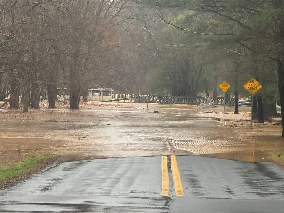
@Eskimo Joe friend on FB shared this, road flooding Bond Road/West Liberty Road, Parkton. Looks like Deer Creek overflowed its banks
- 1,093 replies
-
- 8
-

-
-

-
- severe
- thunderstorms
- (and 1 more)
-
Hoping the rain/winds and (ugh) quick change to snow thing happens.
-
didn’t know you spoke for all kids and what they may or may not go thru and how it impacts them. Good to know.
- 1,093 replies
-
- 3
-
-

-
- severe
- thunderstorms
- (and 1 more)
-
Oh gosh that is scary to think about. I hope the kiddos aren’t too shaken up. My kid would have had a panic attack
- 1,093 replies
-
- 1
-
-
- severe
- thunderstorms
- (and 1 more)
-
Exactly. I get why they did. Others may not and I have it easy as I work from home so it’s no biggie to me that mine came home early. I understand it’s not as easy for others.
-
And if they hadn’t and it was storming when kids let out, people would complain. Schools cannot win either way and always better to err on the side of caution than not
- 1,093 replies
-
- 7
-
-

-
- severe
- thunderstorms
- (and 1 more)
-
Pouring here
-
I’ll never understand following an event when you think it’s a nothing burger. Go find something better to do with your time if you’re not interested. General “you”.
- 1,093 replies
-
- 9
-
-
-
-
- severe
- thunderstorms
- (and 1 more)
-
Regardless of what happens I am happy dance was cancelled tonight and now I don’t have to taxi anywhere
- 1,093 replies
-
- 2
-
-
- severe
- thunderstorms
- (and 1 more)
-
Love the nice skinny line that formed.
-
The northern line really fell apart. Gusty showers.
-
Velocity showing 70+ winds on the storms headed my way
