-
Posts
1,564 -
Joined
-
Last visited
Content Type
Profiles
Blogs
Forums
American Weather
Media Demo
Store
Gallery
Posts posted by PackGrad05
-
-
7 minutes ago, BullCityWx said:
I havent really seen anyone talk winds.
The NAM is showing sustained 20 gusts to 40 in SE Wake by 03z Friday. Gusts to tropical storm force over the sounds and lower banks as well.
That will really help road conditions by drying out the wetness before the freeze comes in!
-
 1
1
-
-
2 minutes ago, RT1980 said:
Wouldn’t higher precip amounts lead to more cooling?
They could... but a less amped storm wouldn't bring as much warming into the mid-levels either.. I'd prefer that version.
-
 1
1
-
-
The 12Z HRRR shows all rain for NC outside of the mountains.
-
 2
2
-
 2
2
-
 1
1
-
-
Folks were discounting the NAM yesterday but now taking it into consideration when modeling the warm nose. I know it is typically pretty good with warm nose but this is also due to the fact it is really amping up the storm. The warm nose is directly related to how strong it amps up that low. If the NAM is overdone, then so is the warm nose.
Plus, the warm nose will go away with this storm as it progresses. It will not persist the entire time.-
 3
3
-
-
I agree with Allan's placements, but would lower the amounts by 1-2 inches for each zone. I would be SHOCKED if southern wake got 1-3 inches. I could see a trace to one inch of sleet/snow slush.
-
In true NC fashion, we go from southern favored areas to more of a northern favored area. Southern Wake better watch out! I've seen this play out multiple times where it takes us too long to transition and never completely get a good snow falling.
-
 1
1
-
 1
1
-
 1
1
-
-
Interesting that their "bullseye" is in the northeast NC region. Probably due to temperatures and less of limiting factors.
-
I'm rooting against the NAM because it is showing that warm nose creeping into Wake. 800mb warm nose would be sleet/rain for most of Wake.
-
1 minute ago, CaryWx said:
Regardless warm nose or not that's a sharp cut in southern Wake co. Either a lot of sleet or rain one. Hope it doesn't change much in next 36hrs.

A sharp cutoff in southern wake is a sure bet with any winter weather! I wouldn't expect any different!
-
 2
2
-
-
-
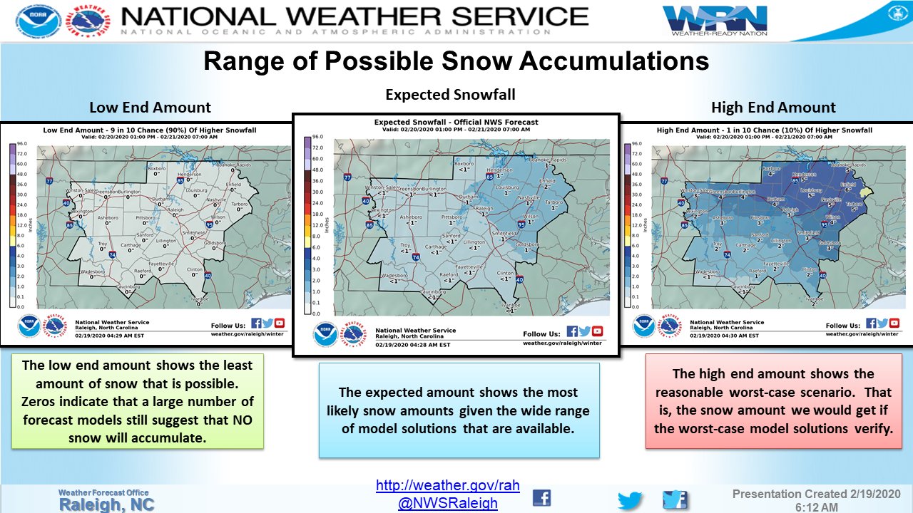
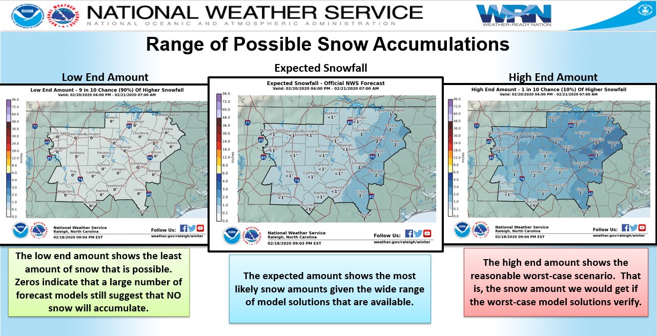
RAH updated their snow maps shortly after 9 and still have wake county less than one inch in the most likely scenario.
-
 1
1
-
 2
2
-
-
Yes, the high is in the same placement in all those but it is taking longer to bleed the cold air over the apps in the euro/eps.
-
-
The QPF of the EURO bumped up due to a closer development of the low near the coast. However, the snow is still anemic because it delays the arrival of the cold air, due to the poor placement of the high.
-
 1
1
-
-
<a href="https://twitter.com/webberweather/status/1229921154556727296?ref_src=twsrc%5Etfw">February 19, 2020</a></blockquote>
<blockquote class="twitter-tweet"><p lang="en" dir="ltr">The 18z European run is folding like a piece of origami to the NAM/GFS. <a href="https://t.co/a25nbIl0bj">pic.twitter.com/a25nbIl0bj</a></p>— Eric Webb (@webberweather) <a href="https://twitter.com/webberweather/status/1229921154556727296?ref_src=twsrc%5Etfw">February 19, 2020</a></blockquote> <script async src="https://platform.twitter.com/widgets.js" charset="utf-8"></script>
<blockquote class="twitter-tweet"><p lang="en" dir="ltr">The 18z European run is folding like a piece of origami to the NAM/GFS. <a href="https://t.co/a25nbIl0bj">pic.twitter.com/a25nbIl0bj</a></p>— Eric Webb (@webberweather) <a href="https://twitter.com/webberweather/status/1229921154556727296?ref_src=twsrc%5Etfw">February 19, 2020</a></blockquote> <script async src="https://platform.twitter.com/widgets.js" charset="utf-8"></script>
<blockquote class="twitter-tweet"><p lang="en" dir="ltr">The 18z European run is folding like a piece of origami to the NAM/GFS. <a href="https://t.co/a25nbIl0bj">pic.twitter.com/a25nbIl0bj</a></p>— Eric Webb (@webberweather) <a href="https://twitter.com/webberweather/status/1229921154556727296?ref_src=twsrc%5Etfw">February 19, 2020</a></blockquote> <script async src="https://platform.twitter.com/widgets.js" charset="utf-8"></script>
I can't figure out how to embed a tweet. help please
-
 1
1
-
-
At this point, we should be able to start seeing if the high pressure and precursor front will set up like the models are predicting...this will help us see if things will verify down the road. Euro holding on to a weaker high and weaker low, hence weaker storm.
(hope this doesn't get deleted like my other posts for some reason)-
 2
2
-
 2
2
-
 1
1
-
-
3 minutes ago, olafminesaw said:
RAH hasn't updated snow maps since 4 pm yesterday. It will be interesting to see how conservative they will be
They updated them at 3:30PM this afternoon. Check their FB or twitter.
-
 1
1
-
 1
1
-
-
Mike Maze on WRAL just said that they are thinking the low will form further off shore and limit the precipitation in triangle. Going for trace to one inch in our area. This is based on their future cast model.
-
 2
2
-
 2
2
-
 1
1
-
-
18Z GFS running. Not looking as cold. Rainy at onset.
-
 2
2
-
 1
1
-
 2
2
-
-
WPC Probabilistic Guidance also decreased across NC. Probably because of lower QPF on recent model runs and EURO run. Still bullseyes central/eastern NC but percentages went down 10-20%.
-
 1
1
-
-
NWS RAH and local mets are still leaning toward the Euro... The fact that it still isn't showing much is concerning to me.
-
 2
2
-
 1
1
-
 1
1
-
-
RAH is very conservative. WRAL has also moved away from posting "snow totals" and moved toward just showing "probabilities." They keep showing "probability of 1 inch" maps. The maps appear to be pretty much identical to euro model and wpc guidance. Which currently only shows about 20-30% chance of 1".
-
 1
1
-
-
Greg Fishel from his Facebookl: "...... In my estimation, the upper level pattern is wrong, the surface high is in the wrong place, and most if not all of the precipitation will fall while temperatures are above freezing. For snow lovers, I do not believe this upcoming late week weather event is going to be your meteorological messiah. Might we see a few flakes? Yes, but every time I venture outside you've got that so what's the big deal??? More to come later today."
-
 1
1
-
-
Regardless of what happens, the overnight hours on Thursday and early morning hours of Friday will be messy and nasty. Especially with temps dropping into the 20s as soon as the system departs.
-
 1
1
-


One More Shot: Feb 20-21 Event
in Southeastern States
Posted
Seems like it is alone with that trend and overamping the system. Really doesn't change much other than how long areas take to transition. Everyone sees snow eventually due to the storm track.