

PackGrad05
-
Posts
1,564 -
Joined
-
Last visited
Content Type
Profiles
Blogs
Forums
American Weather
Media Demo
Store
Gallery
Posts posted by PackGrad05
-
-
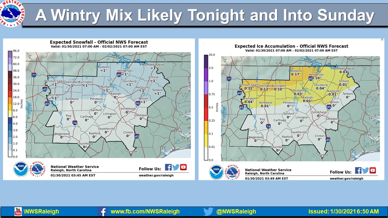
RAH issued a winter weather advisory for Raleigh North and West.
-
HRRR shows some snow with that finger that moves through first for wake county.
-
-
Is this another storm that ends up trending better within 48 hours like the last one? Local news was even mentioning that MONDAY may be the best chance for some light snow around central NC.
-
I think this is a minimal event outside the mountains and foothills. Cold rain is better than ice/power outages.
-
 2
2
-
-
I don't get worked up with those temperature outlooks.
It only takes 1-2 days of cold and moisture to link up to get something. We just had a decent little system for a good number of folks here. I'm sure it'll happen again, if not this weekend, then sometime in Feb.-
1
-
-
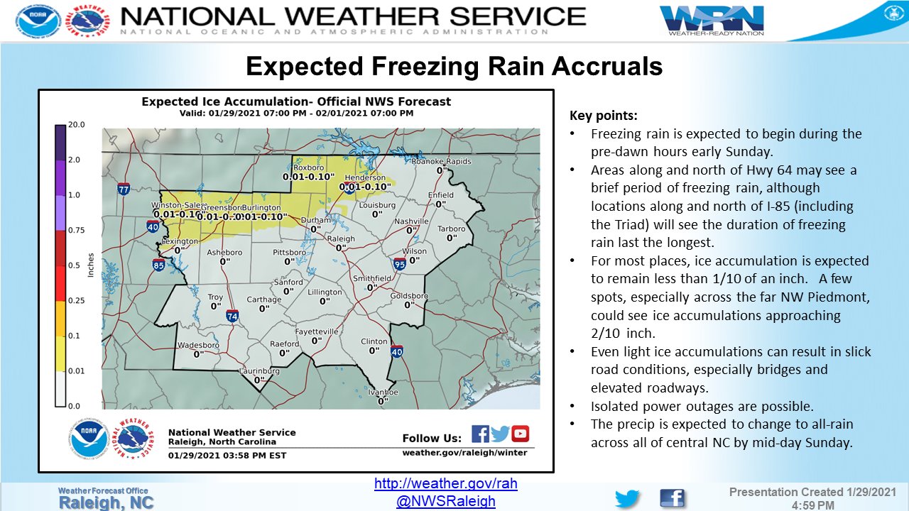
12Z NAM tries to bring in a period of FZRA to north central NC on Sunday... the timing saves a lot of central NC. If the precip sped up, it would be more of an issue.
-
Definitely looks like a triad CAD special. Need it to trend stronger/more south for Wake to get in on the fun.
-
2 minutes ago, CaryWx said:
I might be reading it wrong but looks like retreating cold all morning on Sunday into 1pm. Basically the regular warm up of the day. Unless it stops/holds past that last timeframe it's retreating right?
I agree. That's what I'm seeing. And not even that strong of a signature to me.
-
2 minutes ago, Ghicks said:
how much confidence can we put into the gfs look how it handled the amounts of precip with last nights system
Amounts i'll give you, but track and placement of frozen precip was spot on as we got within closer range.
-
12Z GFS still too far north with the Low for central NC to have any frozen issues. VA/NC border may have some.
-
1 hour ago, Brick Tamland said:
Still plenty of time for the Euro to shift south. It didn't shift south with the storm tonight into tomorrow until last night.
What did the individual EPS members show? as far as snow for RDU? Yesterday's, all 50 members showed something.
-
12Z GFS remains unimpressed with sunday's system.
-
Wake County looks to do better with tonight's system than the weekend system (as of now). I hope it just stays snow or rain.... I don't need ice issues.
-
I agree with everything in the RAH discussion.. I'm going for dusting - 1" for southern wake. Grassy surfaces...melting by afternoon.
-
 1
1
-
 1
1
-
-
3 minutes ago, magpiemaniac said:
Most of these models said I’d be in the 60s today. I’m at 41 degrees currently. I’m getting a foot of snow Thursday morning, dammit.

The NAM wasn't buying the warm temperatures. It was one of the first models to show the wedge.
-
1
-
-
I would lean toward the NAM at this point. Given thermal profiles
-
This is the craziest thing I've seen. (well, not really since I've lived in central NC my whole life).
Local meteorologists must be going crazy....
You also have to remember that most of these model outputs assume 10:1 and combine sleet/snow, etc...
Looking at soundings, it really doesn't cool off enough until the end, and then barely if that. -
1Z NAM looks decent, but 3K NAM says nope...
HRRR is a mix between the two. The end of the run is 12Z on Thursday and most of precip will be done by then anyway. -
Depending on temperatures/dew points, saturday/sunday event could be an in-situ damming
-
1
-
-
the 6z NAM was a little juicer than 3K NAM, but both seemed to jump south... Still just having a hard time buying it with the cold chasing moisture scenario at the end of this system. Unless there is some banding at the end.
-
1
-
-
0Z NAM shows some token flakes and maybe a trace of snow across central NC on the tail end of the system Thursday morning. Cold chasing moisture though. 3K gives northern wake almost an inch.
-
The 18Z GFS was trying to show something for Feb. 7. Low off the coast and high pressure in a somewhat favorable position, but weak 1030
-
If the NAM verifies with the wedge tomorrow and temperatures in northern/central NC don't get quite as high as originally predicted, that would bode better for temperatures cooling off quicker wednesday night
-
1
-
Jan 31st CAD event
in Southeastern States
Posted
The local news (raleigh area) has been more keen on the chance of snow here on Monday. They mentioned it last night and again today.