

PackGrad05
-
Posts
1,564 -
Joined
-
Last visited
Content Type
Profiles
Blogs
Forums
American Weather
Media Demo
Store
Gallery
Posts posted by PackGrad05
-
-
Still looks decent for Wake. At least something to look at.
-
4 minutes ago, Buddy1987 said:
Junk model lol. Globals are starting to converge on “something”. Ever since the nam was upgraded it produces paltry and meager precip amounts.
Interesting. In year's past, I've given more credit to NAM within a shorter range.
-
The 12Z NAM (both 32km and 12km) were not impressed...
Neither was the 18Z 12km.
-
I'm intrigued about the time period after 12/23... I think we see some favorable patterns then.
-
 1
1
-
 1
1
-
-
1 hour ago, NorthHillsWx said:
Heck of a dry stretch setting up while it’s already been quite drive this entire month. Seeds of a drought? Haven’t mentioned that word in here for a few years
While the temperature isn't warm enough for my Bermuda to take off yet, I would like a little moisture to help green it up.
With that said, I've absolutely loved all the time outside my family has been able to spend...especially with no humidity and sweating to worry about. -
11 minutes ago, StormySquares said:
I think the 12z HRRR redefined what the ceiling may be
The Apps/Smokies better keep their eye on things tomorrow night!
-
Unfortunately, yesterday was a big bust. No other way to put it. That just goes to show how complicated the science is. With that said, both NWS and local mets consistently explained ways that this could end up being less of a big deal.. However, it is tricky because you want people to be prepared in case the ingredients do come together in a Level 3/4 fashion.
-
For those who follow Greg Fishel on facebook, he pretty much nailed it. He was never completely sold on it and then quickly identified the mesolow that formed this afternoon.
-
4
-
-
I'm in southern wake near Fuquay and up to 68 with a soupy dewpoint.
-
11 minutes ago, NorthHillsWx said:
Noon update: still firmly stuck in the wedge and 57 degrees with fog/mist
I'm in Southern Wake and already up to 62.
-
1
-
-
For central NC, it looks like the main time to watch is between 3-8PM. HRRR has consistently shown some showers/storms around 4PM, but then fires up a more severe looking cluster of cells between 6-8PM.
-
both RAH and local Mets have said that the warm air really wouldn’t surge up here until after 12 noon if it did. So I’ll hold off on until tonight to see if things remain stable.
It’s only 9:55am -
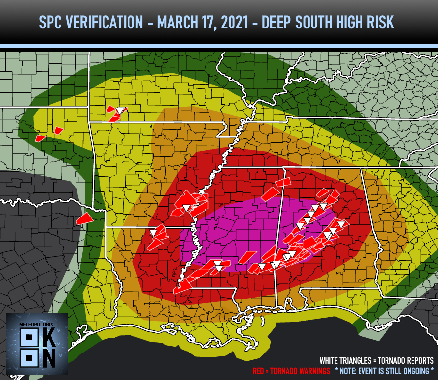
Would you say that the probability of no tornados per unit area in a high risk area is the same as a tornado per unit area in the slight risk area?
Areas in the high risk had tornados. A majority of the tornado reports (as of that graphic) were in the high area. What percentage of the high risk area needs to have a tornado for it not to be considered a bust?
You could argue that sliver of the slight was also a bust since it had numerous warnings and a tornado report... or could you?
-
1
-
-
-
Here is the specific wording from RAH this afternoon. They agree the wedge may be stubborn, but also believe the boundary will be the focus.
QuoteInitially, that cold air damming regime of widespread low overcast, light rain and drizzle, and (dense) fog, will retard the nwwd retreat of the wedge front into cntl NC during the late morning to early afternoon hours Thu and mitigate the severe risk to its north. That boundary will also likely prove to be the locus of (SPC Moderate Risk) of severe, where frontal forcing will most likely overcome the warm layer/capping inversion
-
As for central NC, RAH said earlier in their discussion they felt like the focus of the severe weather would be along US-1 (30 miles either side) due to location of the front and dynamics associated with it. They actually mentioned this location would be the worst of it potentially. This is something models would have a hard time showing in their output.
With that said, they also mentioned several caveats that could decrease the activity. I hope all of them come true. -
latest HRRR and 3K NAM not looking too bad for central NC either. Primarily one main line of broken cells around 4-5PM. Just wondering if they aren't handling it properly?
-
I saw a meteorologist from MS post last night that by dark, people would be calling him an idiot, and he expected most of their action to take place after dark. I can't find it now or remember who it was.
-
2
-
 1
1
-
-
Personally, I was surprised with the large moderate area for NC/SC. I knew there would be a moderate area, but I was surprised at the northern extent of it.
I think this is where experience with CAD comes into play. It will truly be a question of how far north and west the CAD erodes during the day... The moderate area looks to align with your typical ice/rain border in winter weather.-
3
-
-
is TorCon their version of sig tor parameter? Or is it something different?
-
46 minutes ago, Avdave said:
IT will be trimmed back, I dont think we really get into the humid and moist airmass. This is just like winter, we miss the meat of the storm here in the Triangle. I rather be in Fayettenam or Lumberton to SC for this one if I want severe thunderstorms
I'm surprised they went with the enhanced for such a large area so far in advance. Seems it would've been better to go with a large slight and then increase to enhanced as needed. Unless they wanted to raise awareness early.
-
New run of WRAL future cast model shows a less widespread event for central NC. They are hopeful trend will continue and level 3 area be trimmed back.
-
WRAL just said they have noticed a trend with “storm energy” (probably CAPE) being higher east of Raleigh. Said they are watching to see if the level 3 area is trimmed back tomorrow.
-
20 minutes ago, Bob's Burgers said:
Some of the soundings in North Carolina for Thursday look better than tomorrow's event.
What do you mean by better? Better for creating severe weather or better as in less severe weather?
January 3rd wet snow potential
in Southeastern States
Posted
Still looks like a 3-4 hour period of wet snow for Wake.