

PackGrad05
-
Posts
1,564 -
Joined
-
Last visited
Content Type
Profiles
Blogs
Forums
American Weather
Media Demo
Store
Gallery
Posts posted by PackGrad05
-
-
Remember this is the same time period that many models lost the storm last week only to trend back with better data as the date drew near.
-
 1
1
-
 1
1
-
 1
1
-
-
EURO has been most consistent with this event. Interested to see what 12Z ensembles show.
Other guidance appears to be trending that way.-
 1
1
-
-
Still plenty of time.
Nothing has really changed over the past 2-3 days if you look at the big picture.
Still looks like a rain/snow event with light amounts possible over central NC. -
Euro has been most consistent so far. Less fluctuations.
-
1
-
-
Great article about how ensembles work if anyone is interested. https://www.wral.com/how-wral-meteorologists-use-ensemble-forecasting-to-determine-the-chance-of-1-or-3-snow-in-your-town/20099023/
-
1
-
-
Latest from local station. I think they have just resorted to posting EURO ensemble probabilities and just update it every 6 hours.
-
2
-
-
The latest update from WRAL. Posting European ensembles again.
https://twitter.com/mazewx66/status/1486087212534050817?s=21-
1
-
-
Euro ensembles will be a better gauge.
-
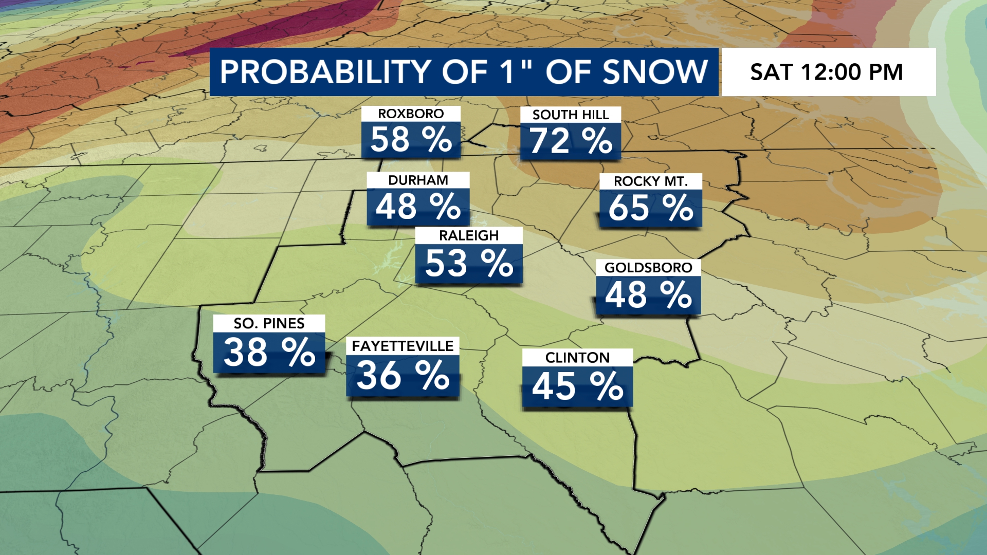
From Mike Maze:
Many folks have been reaching out about the possibility of a major winter storm this weekend. Today's model runs are not showing it at all. Here's a look at the European Ensemble probabilities for 1" of snow ending Saturday night. Does not look good to me right now.
Ensemble map shows 26% chance of 1" of snow for Wake.-
1
-
1
-
-
Starts as rain and then changes to snow as it gets cranking.
-
Just now, Brick Tamland said:
No
Yes, they did say that. It was on their blogs.
I haven't verified the accuracy of the statement though.As for next weekend, the signal is there, but cold air looks limited for now.
-
the local mets said that the EURO was most consistent with this weekend's storm from day one..
-
1
-
 1
1
-
-
The roads are getting nasty out there. WRAL just had a crew on I-95 in Johnston County and it was horrible.
-
1
-
-
4 minutes ago, CaryWx said:
Any mets on social media chiming in about lower rates in the Triangle or honking be patient.
The forecast looks pretty spot on to me so far. There are still several hours at least of snow to go and we already have about an inch in southern Wake. Most predictions I saw for this area were in the 1-3" range.
-
Remember when a lot of folks were freaking out about that run of the NAM that shows the storm disappear?
This should be a lesson to never freak out over one or two bad model runs.-
5
-
-
The main banding is definitely setting up along I-95 area.
-
I'm also watching the temperatures. Here in southern Wake I'm up to 30.4. Most of the news stations were saying we'd be in the upper 20s all day.
-
 2
2
-
-
12Z Nam 3K thermals are very close to sleet at onset for Wake. I do think we see a little sleet to start and then enough cool down to transition to snow.
HRRR thermals are a little cooler at mid levels.
-
I'd be shocked to see more than 3" anywhere in Wake. Trust me, I'm pulling for it, but based on climatology and situations like this in the past, I agree with RAH's statement about the dry air this far back and the extent of the western precip shield.
I'm going 1-3" across Wake, with most areas 1-2". Still a great snow!
-
2
-
1
-
-
No snow in Southern Wake (willow springs) this morning. I did see some falling around midnight but nothing accumulated.
Hoping that being in the southeast part of the county pays off for once tonight! -
Just now, scottk said:
I may have read the forecasts wrong but I did not expect there to be basically no precipitation across SC and NC at this point…
A lull for most of the day was expected across central NC. The low doesn't really intensify until later this afternoon toward evening..
-
I'm not sold on anything that noticeable for Wake with tonight's first round. Cold chasing moisture and it looks like limited moisture by the time temperatures get low enough for anything appreciable.
As for the main round tomorrow, it's going to be really close with how far west the main precipitation gets... It is going to be painful for someone...
I'm going 1-3" across Wake.-
2
-
-
What time is the first and second round?
-
6 minutes ago, NorthHillsWx said:
One other note before I have to go back to work- these “clown maps” will likely verify with this storm being the high ratios we should have with pure arctic air. Usually you shave a good % off those maps due to warm ground/borderline temps/mixed precip, but in the all-snow areas we actually don’t have anything I see to negate accumulation. By the time this starts it will have been in the 20’s for hours and will be falling into temps in the lower-mid 20’s. I wouldn’t be surprised to see some people shocked with how well this piles up under those conditions compared to a “normal” event here
Agreed. This is one of the rare times when Kuchera numbers are higher than the 10:1 numbers.
SREF plumes for Raleigh are also higher than this point yesterday.
I'm glad to be south of Raleigh this time.-
3
-
Potential 1/28-1/30 2022 winter storm
in Southeastern States
Posted
Euro ensembles are what matters. Waiting on those.