

PackGrad05
-
Posts
1,564 -
Joined
-
Last visited
Content Type
Profiles
Blogs
Forums
American Weather
Media Demo
Store
Gallery
Posts posted by PackGrad05
-
-
16 minutes ago, eyewall said:
I think for Raleigh we may be too far NW to see much out of this. I am just hoping one solid outer band makes it up for drone shots.
High res NAM and HRRR are still showing a steady rain from this afternoon all the way to mid-morning. I definitely think the big story will be ponding/localized flooding. Morning commute could be messy. Scattered power outages as always.
Big gradient possible across Wake (as always).-
 1
1
-
-
Looking at impacts for NC, particularly central NC. Getting in range of high-res models. NAM 3K is bullish on some heavy rain bands setting up, particularly Thursday morning thru mid-day. Could get pretty gusty as well during those bands. Most of central NC in flood watch now.
-
1
-
-
6Z GEFS and EPS are almost identical and tightly packed.
-
With so many consistent moves to the east, a move back west wouldn't be surprising at this point. It's really going to depend on the speed and the trough strength to the north.
-
2
-
-
There is still a decent amount of spread in the ensembles (both EPS and GEFS) with regards to impacts on the SE coast. The exact track will determine impacts not only at the coast, but inland.
-
2
-
-
12Z GFS is almost identical to ECMWF and EPS. Rides GA/SC coast and then turns east at Cape Fear out to sea.
-
6Z EPS model consensus is tight around a big bend landfall and then riding the GA/SC/NC coast up to Cape Fear. ECMWF, UKMET, and ICON largely agree.
6Z GEFS model consensus slightly west of this.
-
2
-
-
NAM definitely has higher CAPE than GFS and EURO.
-
Crazy how much the GFS changed. Tons of rain for NC to absolutely nothing. It'll keep wobbling.
-
Both the GEFS and EPS are trending in the right direction, which is all we can really watch at this time....trends.
-
1
-
-
Neither of the ensembles (euro or gefs) are on board yet.
The 00z ecmwf also shows zilch.
. -
The signal on both the EPS and GEFS is honestly the best it has looked this season, especially this close to the event.
-
1
-
-
On 2/27/2023 at 8:07 AM, PackGrad05 said:
The 00Z EPS really likes the 11-13 time period... Still watching that.
Also watching severe potential for Friday.
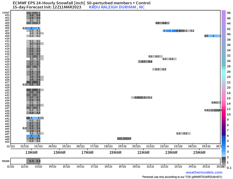
I first mentioned this back on Feb. 27. EPS still has a signal for 11-13... GEFS coming on board.
-
18 minutes ago, tarheelwx said:
Honestly, I don't think the ensembles have been any better in the extended than the operationals.
So Pack, was the signal a faint distant heartbeat, or something more solid? Feel like Lucy is back at it again.
TW
The EPS has had the signal for the past 3-4 days.... it is more faint now, but still there.
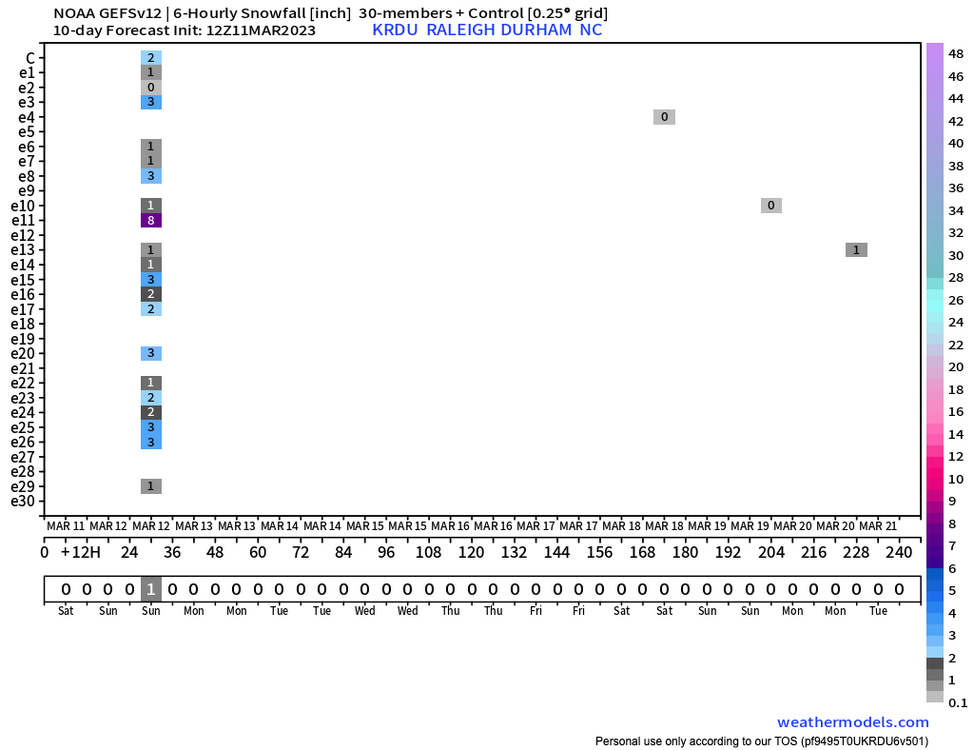
GEFS has not been as robust... honestly the most recent run only had one member out of 30....
I'm just a snow lover at heart and want to see some falling.
-
both the EPS and GEFS came back with a signal for March 11-13 time period.
-
Models are back to being more aggressive with the non-convective wind gusts across the Piedmont, with gusts possibly to 50 mph+. Starting to look like this may be the bigger story than severe weather, for NC anyway.
WRAL just showed wind forecast and the highest it got was around 20s tomorrow night.
Didn’t act like it was a big deal here.
. -
Classic Wake County gradient. By the time it got here (if it even was still a storm by then), it would have moved 100 miles NW.
-
1
-
-
Friday isn't looking quite as bad for RDU based on the track of the low (further north and west).
That's a good thing but got to keep monitoring.
-
The last 2 runs of the EPS have been a nice look for March 9 - 13 time period.
-
1
-
-
The 00Z EPS really likes the 11-13 time period... Still watching that.
Also watching severe potential for Friday.
-
Turned my attention to March 9-11 now.
-
1
-
 1
1
-
 1
1
-
-
Both the latest EPS and GEFS have members showing snow for RDU around 3/4. The EPS has been consistent with it (50% of members or less) for the past couple days.
-
EPS seems to be trying to sniff something out around the beginning of March. GEFS starting to bite as well.
-
1
-
-
23rd - 27th looks interesting?
-
1
-

Category Five Hurricane Lee
in Tropical Headquarters
Posted
12Z EPS members