high risk
-
Posts
3,150 -
Joined
-
Last visited
Content Type
Profiles
Blogs
Forums
American Weather
Media Demo
Store
Gallery
Everything posted by high risk
-

2020 Mid-Atlantic Severe Weather - General Thread
high risk replied to Kmlwx's topic in Mid Atlantic
He assisted at the cleanup at the Maryland Fire and Rescue Institute which was heavily damaged and suffered a heart attack while driving home that evening. Who knows if he would have suffered the cardiac episode had he not been at the scene..... -
I'd love to see what the models actually look like today, as WPC has some big totals for our area in the next 24 hours and a SLGT risk for flash flooding overnight.
-
2020 Mid-Atlantic Severe Weather - General Thread
high risk replied to Kmlwx's topic in Mid Atlantic
yeah, CAMs have a good signal for storms later this afternoon, mainly for DC and points south. As SPC notes, instability is weak, but shear is fairly good, and the forecast soundings show some good DCAPE, so I guess I agree that some gusty winds are possible. -
2020 Mid-Atlantic Severe Weather - General Thread
high risk replied to Kmlwx's topic in Mid Atlantic
Hello, SPC? Hello? Time to get that box issued. -
2020 Mid-Atlantic Severe Weather - General Thread
high risk replied to Kmlwx's topic in Mid Atlantic
I think you're in as good of a location as any. I'm very bullish on the SVR threat today, just more bearish than most on the tornado threat (although I think that a TOR watch will be and should be issued). The 18z LWX sounding should be a big help in understanding the magnitude of the threat. -
2020 Mid-Atlantic Severe Weather - General Thread
high risk replied to Kmlwx's topic in Mid Atlantic
it really is, although kmlwx and I are not quite in lock step today..... -
2020 Mid-Atlantic Severe Weather - General Thread
high risk replied to Kmlwx's topic in Mid Atlantic
I agree that QLCS tornadoes are the bigger (although still not a huge) threat. There is enough shear to get rotation today, but the low-level shear still looks pretty marginal to me. We need the low-level flow to strengthen and back to have a larger threat, and that's not progged on a large scale, so we'll have to look for mesoscale areas that get their low-level winds modified by nearby ongoing convection. -
2020 Mid-Atlantic Severe Weather - General Thread
high risk replied to Kmlwx's topic in Mid Atlantic
Many things to like about Thursday afternoon, but I'd sure like to see some stronger 10m wind speeds. There will be mesos for sure, but we need some better speeds at the sfc to really get a legit TOR event. -
2020 Mid-Atlantic Severe Weather - General Thread
high risk replied to Kmlwx's topic in Mid Atlantic
I don't really understand why the line was so meh. The 00z IAD sounding isn't bad. Maybe the CAPE is a bit tall and skinny, and deep layer shear is marginal, but I would have expected an organized line like that to have a lot more wind. -
2020 Mid-Atlantic Severe Weather - General Thread
high risk replied to Kmlwx's topic in Mid Atlantic
So the box is out...... but it's BLUE. I guess I'm not surprised (that it's not a red box) given the linear evolution, but the shear parameters argue that a few embedded mesos are quite possible. -
2020 Mid-Atlantic Severe Weather - General Thread
high risk replied to Kmlwx's topic in Mid Atlantic
SPC Mesoanalysis shows the supercell composite here increasing to 8 here over the next couple of hours. Given that and most of the CAMs showing convection developing by now, I'm assuming that's why they went with such high watch probs. I'd think that the convection to the west should do better as it moves east into the better environment, but we'll see. -
2020 Mid-Atlantic Severe Weather - General Thread
high risk replied to Kmlwx's topic in Mid Atlantic
Yeah, I'm a bit surprised, and I think that SPC is too. Latest HRRR still suggests that the convection firing near the I-81 corridor will still become a bigger deal further east in a few hours. -
2020 Mid-Atlantic Severe Weather - General Thread
high risk replied to Kmlwx's topic in Mid Atlantic
I only had to whine for 23 hours before SPC finally put us in the SLGT risk we warranted. -
2020 Mid-Atlantic Severe Weather - General Thread
high risk replied to Kmlwx's topic in Mid Atlantic
Hard to argue with this. I'm still more bullish for today than most, but I understand the question marks. For tomorrow, the potential is real. My only concerns are the weaker lapse rates (although they are now progged a bit better than earlier guidance) and potential weak sfc wind speeds (although the NAM nest seems to be weaker than some other models) I'd still prefer today's lapse rates with tomorrow's wind profiles, but good luck getting those two to align in this region..... -
2020 Mid-Atlantic Severe Weather - General Thread
high risk replied to Kmlwx's topic in Mid Atlantic
Even without full heating, the lapse rates today in the forecast soundings look good, so I don't think we need to get much above 84 or so to have an active late day. -
2020 Mid-Atlantic Severe Weather - General Thread
high risk replied to Kmlwx's topic in Mid Atlantic
I completely get that SPC doesn't want to issue a huge SLGT on a day like today from TN to the northern NY border, but I would still argue for a SLGT in our area. The CAMs still really like DC metro later today, and that's reflected in HREF probabilities. Both the ops (left) and para (right) indicate high probabilities of updraft helicity exceeding 25. (That's a low end threshold, but it still reflects that there is strong agreement in intense cells with at least weak rotation. And the probabilities of higher UH thresholds are not terrible either....)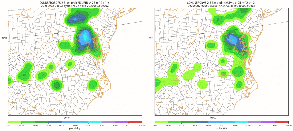
-
2020 Mid-Atlantic Severe Weather - General Thread
high risk replied to Kmlwx's topic in Mid Atlantic
Yeah, I really thought they should have pulled the trigger, but it's not a big deal if they wait. SPC mentions questions about coverage/intensity; I thought that the most of the entire suite of 12z CAMs looked good with those aspects, but they clearly want to see if the trends in the guidance hold. -
2020 Mid-Atlantic Severe Weather - General Thread
high risk replied to Kmlwx's topic in Mid Atlantic
It would be a once-in-a-lifetime event, but if it can happen in upstate NY and in central NC..... May 31, 1985 showed that outbreaks with high-end events CAN happen in the east. I envision a deepening 980 sfc low over NW PA during an afternoon, with intense wind fields at all levels and all CAMs showing discrete convection and strong, long-track UH signals over the Mid-Atlantic. Of course, in an intense synoptic setup, we usually screw it up with either early morning crapvection..... A HIGH here would never happen for a TC remnant event. -
2020 Mid-Atlantic Severe Weather - General Thread
high risk replied to Kmlwx's topic in Mid Atlantic
This would be an awesome discussion over a few beers at an AMS conference. For the 2012 event, CAM guidance was really limited. The NAM nest had little handle on this event, and the HRRR had some good runs but was still experimental. There were real questions about whether the derecho would survive crossing the mountains, and even at 1z, SPC still wasn't totally sure how far east it would maintain strength. I still envision getting to a point in such an event where there is agreement that an intense derecho will blast through the Ohio Valley and make it to the coast, and SPC will launch the HIGH. It won't happen right away, but we'll get there. -
2020 Mid-Atlantic Severe Weather - General Thread
high risk replied to Kmlwx's topic in Mid Atlantic
Am I THAT predictable? I can't even imagine what a synoptic setup would look like for an actual high risk here. If it were to happen, my guess it would be for wind in a derecho event that has incredible predictability. Derechos here haven't been particularly predictable in the past, but advances in NWP will eventually change that. -
2020 Mid-Atlantic Severe Weather - General Thread
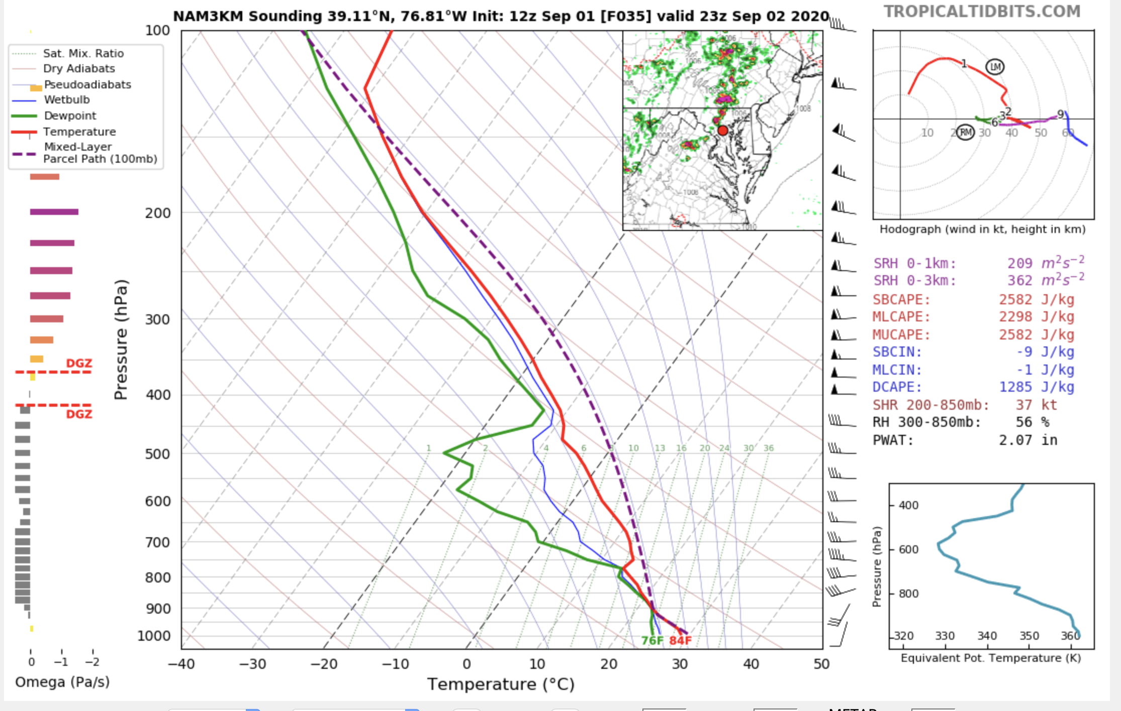
high risk replied to Kmlwx's topic in Mid Atlantic
To expand on my interest in tomorrow, this is a pretty good look (minus the warm temps around 750 mb and weak winds in the layer just above):
-
2020 Mid-Atlantic Severe Weather - General Thread
high risk replied to Kmlwx's topic in Mid Atlantic
FWIW, the NAM nest soundings look way better for Wednesday, both in terms of shear and instability, and the simulated radar isn't bad. HRRR looks pretty good too, and all of the CAMs suggest storms scattered through the area late Wednesday. If I wanted to go into weenie mode, I'd note some low-level curvature in the hodographs..... Thursday has a better shortwave. For now, the Thursday soundings in the NAM nest lack instability, but deep-layer shear is there, and the event certainly has potential too. But I'm intrigued by what I'm seeing for the first event and would suggest that we could get a day 2 SLGT for Wednesday in the early afternoon SPC update. -
2020 Mid-Atlantic Severe Weather - General Thread
high risk replied to Kmlwx's topic in Mid Atlantic
With radar showing a lot of activity forming over WV, indicative of strong forcing that will overspread our area over the next few hours, the scenario of multiple rounds certainly seems plausible. -
2020 Mid-Atlantic Severe Weather - General Thread
high risk replied to Kmlwx's topic in Mid Atlantic
Look at the 17z HRRR, and then wipe your drool off of the screen. -
2020 Mid-Atlantic Severe Weather - General Thread
high risk replied to Kmlwx's topic in Mid Atlantic
The main system over PA definitely has limited south movement, but several CAMS show development in MD occurring either 1) due to outflow from that complex coming south or 2) on its own.