high risk
-
Posts
2,908 -
Joined
-
Last visited
Content Type
Profiles
Blogs
Forums
American Weather
Media Demo
Store
Gallery
Everything posted by high risk
-

2020 Mid-Atlantic Severe Weather - General Thread
high risk replied to Kmlwx's topic in Mid Atlantic
Blue box issued. Montgomery and Howard are in the far southeastern corner, consistent with the idea that this first show will mainly be a fair distance northwest of the I-95 corridor. -
2020 Mid-Atlantic Severe Weather - General Thread
high risk replied to Kmlwx's topic in Mid Atlantic
I'd say overall that southern PA has a slightly higher threat for SVR than the DC area, with a clear CAM consensus for a batch of storms to develop by mid afternoon over far eastern WV and northwest MD and track northeast towards the York and Harrisburg area. -
2020 Mid-Atlantic Severe Weather - General Thread
high risk replied to Kmlwx's topic in Mid Atlantic
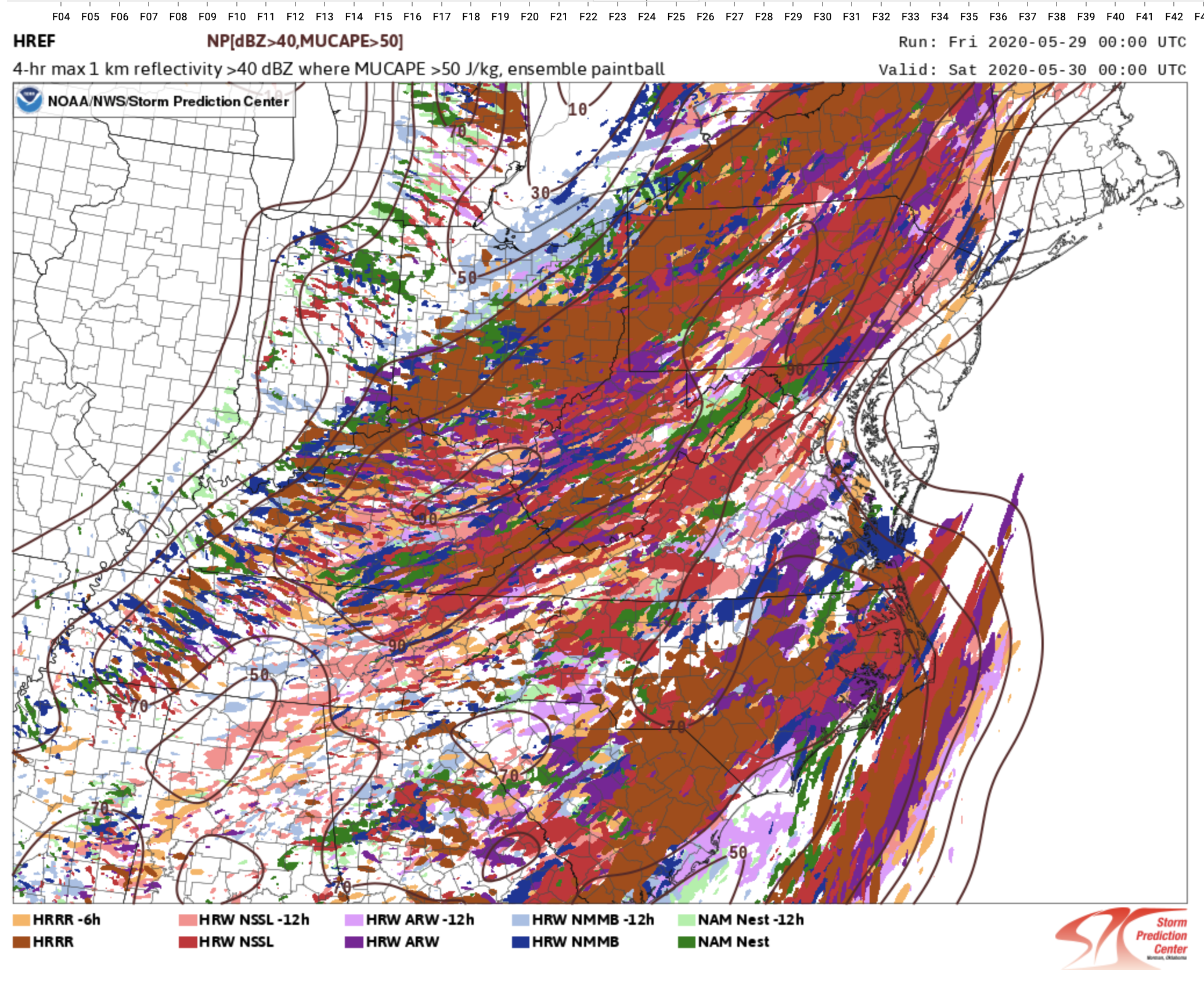
https://www.spc.ncep.noaa.gov/exper/href/ (under forecast tools) and if you want information on the upcoming HREFv3 upgrade: https://www.emc.ncep.noaa.gov/users/meg/hrefv3/ -
2020 Mid-Atlantic Severe Weather - General Thread
high risk replied to Kmlwx's topic in Mid Atlantic
Still unsure whether storms will make it into the DC metro area. There is a better signal for storms moving northeast through northern MD, but anything in DC metro may be an iffy late evening show. It's reflected in last night's HREF members showing 40 dbz which show a clear minimum of members showing storms for DC and points east between 4 and 8pm. (Yes, the 6z NAM came in with a better solution, as shown in the previous post).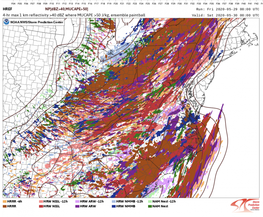
-
2020 Mid-Atlantic Severe Weather - General Thread
high risk replied to Kmlwx's topic in Mid Atlantic
The outlook is pretty legit, but as Amped noted above, the timing now definitely favors those west of the a line from Fredericksburg to Frederick. I'm not really seeing the tornado potential in the forecasted wind profiles, but there is definitely enough deep layer shear (accompanying the modest instability) for SVR. -
impressive tropical downpour here over southern Howard County just before 2pm
-
2020 Mid-Atlantic Severe Weather - General Thread
high risk replied to Kmlwx's topic in Mid Atlantic
The 12z HRRR shows this scenario. It has low-topped convection moving from south to north, in an environment with some instability and good low-level directional shear. The HRRR is more favorable than other CAMs in terms of instability and shear (which is why its reflectivity looks better than most other solutions), so it may be considered a bit of an outlier for now, but it's within the range of possible outcomes. -
2020 Mid-Atlantic Severe Weather - General Thread
high risk replied to Kmlwx's topic in Mid Atlantic
That would still be the best SVR day we've had all month, and it ain't even close. -
With the threat for widespread soaking rains this week dropping significantly, it's worrisome because the longer ranges don't offer much hope. This is supported by the CPC outlooks through day 14 showing below average precip in a large part of the east.
-
2020 Mid-Atlantic Severe Weather - General Thread
high risk replied to Kmlwx's topic in Mid Atlantic
Fire up the thread - we have a day 3 MRGL!!!! It's remarkable in May that we've gone two weeks without even the need for a wishcast, and Friday doesn't look all that impressive, but we take what we're given. There are big timing differences with the front, and instability is not all that exciting, but if we can get storm initiation later Friday, deep layer shear appears to be sufficient for a few cells to reach severe limits. -
well said! At least last week, we watched places further north being even more cold and miserable (with some snow!), but next week, we'll watch it be 80 by Hudson's Bay and 75 in Maine.
-
sure did forget the critical word 'like' in there. Ugh. Definitely looks now like some form of an eastern trough early next week and (depending on exact location/orientation) potentially some unpleasant weather. Still looks much warmer for the latter part of next week, although that is contingent upon said trough being able to depart.
-
There certainly does seem to be some agreement on a strong eastern ridge for the 2nd half of next week with some July-like 850mb temps. For the early part of next week, I don't seeing the eastern trough with associated backdoor cold front being shown by several models today.
-
Also, most of the CAMs have a forced line of heavy showers rolling through on the front around 8pm. If that's right, should be a nice, gusty downpour.
-
NAMs backing off on the threat of the rain ending as period of snow Friday evening, but there is a clear signal for snow/graupel showers Saturday.
-
It's being run every hour in parallel, but COD is only displaying a few cycles. It's in its final stability test; if no problems occur in the next 2+ weeks, HRRRv4 will replace HRRRv3 in operations on May 26. Tons of good information here: https://www.emc.ncep.noaa.gov/users/meg/rapv5_hrrrv4/
-
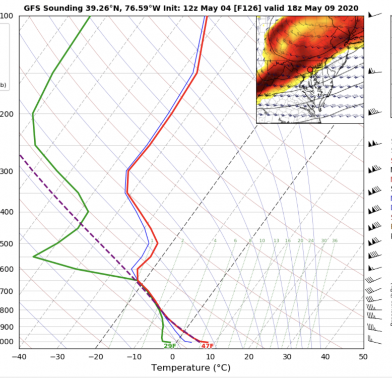
Saturday could be a particularly interesting day. Taking the GFS verbatim, you'd have a strong trough axis sweeping through at 'peak heating' with strong lift and very cold temps aloft.... Graupel showers on May 9??
-
2020 Mid-Atlantic Severe Weather - General Thread
high risk replied to Kmlwx's topic in Mid Atlantic
The SPC outlook discussion is spot on. Forcing is strong, but the soundings look very meh. Best chance of severe will definitely be further south (as suggested by EJ), where temps will be warmer, giving some hope of modest cape, but it's pretty iffy there too. For those north of DC like me, I'll be happy with thunder: NAM nest looks great for that, but it's a bit of an outlier, with several other CAMS not showing good reflectivity signals north of 66 (VA) and 50 (MD). -
2020 Mid-Atlantic Severe Weather - General Thread
high risk replied to Kmlwx's topic in Mid Atlantic
Indeed! check out the 12z NAM nest for Sunday afternoon. -
2020 Mid-Atlantic Severe Weather - General Thread
high risk replied to Kmlwx's topic in Mid Atlantic
While it looks like we'll hopefully avoid some of the nastier scenarios being depicted by various guidance in recent days, I don't think it's worthy of a 'meh' either. We'll still have a 60+ knot low level jet, some very strong lift from multiple sources including upper difluence, and impressive PW values, and even hi-res guidance can often underdo precip in these events. And while it looks to be fairly progressive, there are still some hints of a "round 2" Thursday afternoon in the HRRR and ARW2. Certainly the best chances for big amounts are east of DC, but the chances of really huge totals seem lower now, they're not zero, and we'll still have to deal with issues associated with a heavy event in a short period of time at a minimum. -
2020 Mid-Atlantic Severe Weather - General Thread
high risk replied to Kmlwx's topic in Mid Atlantic
Yeah, wind profiles look awesome to our west Wednesday night, but instability is negligible. On Thursday, the wind profiles along the I-95 corridor will be decent, but instability again looks to be effectively nada. Agree with EJ that any threat would be flooding. It had been looking like the axis of heavy rain Thursday afternoon would set up just to our east, but the 12z NAM is slower, and a heavy rain threat may set up for DC and points east. -
It's worth checking out the overnight runs of the HRRR. All of them have some healthy reflectivity signals for later this afternoon over most of Maryland east of the Potomac. The freezing levels are really low, so if this is right, these would be showers with likely graupel or small hail. It's worth noting that I haven't seen nearly as good of a signal in the other hi-res models, but the HRRR is consistent.....
-
2020 Mid-Atlantic Severe Weather - General Thread
high risk replied to Kmlwx's topic in Mid Atlantic
very reasonable MD issued. a respectable 65/45 at BWI. heating is good - just need to maintain low to mid 40s dew points. It has mixed out to 41 at IAD, but the models have consistently shown a less favorable environment on the west side of DC. -
2020 Mid-Atlantic Severe Weather - General Thread
high risk replied to Kmlwx's topic in Mid Atlantic
Yeah, that area is going to have trouble with dew points due to downsloping. Upper 40s here. T/Td will be fun to monitor over the next 3 hours. -
2020 Mid-Atlantic Severe Weather - General Thread
high risk replied to Kmlwx's topic in Mid Atlantic
I'm slightly more bullish about this than you due to the impressive dynamics, but the better solutions say that we're roughly 64/48 just ahead of the storms. If we don't get there, it will definitely be lame.