high risk
-
Posts
3,160 -
Joined
-
Last visited
Content Type
Profiles
Blogs
Forums
American Weather
Media Demo
Store
Gallery
Everything posted by high risk
-
I came in over 1" a bit south of you, but as pretty as this was, it's been frustrating to watch several bands fall apart on our doorstep.
-

Feb Long Range Discussion (Day 3 and beyond) - MERGED
high risk replied to WinterWxLuvr's topic in Mid Atlantic
Agreed, Bob. This one has high-impact potential for a lot of people here, although the 12z Canadian now has a very different solution, so I don't think that the synoptic details are totally locked in yet. -
Feb Long Range Discussion (Day 3 and beyond) - MERGED
high risk replied to WinterWxLuvr's topic in Mid Atlantic
I'm talking about the Thursday-Friday event. Still time to change, but it certainly looks like we will be too warm upstairs for all snow. My point is that the GFS often wipes out the cold air at the surface and turns us to rain, so when I see it maintain the below freezing temps throughout the event and give us a big ice accumulation, the threat is really legit. -
Feb Long Range Discussion (Day 3 and beyond) - MERGED
high risk replied to WinterWxLuvr's topic in Mid Atlantic
When the model that struggles the most with maintaining cold air damming has a solid signal for a long-duration cold air damming event, I definitely take notice. -
It's weird - I thought it might be an initialization issue, but the HiResW ARW2 (NSSL-WRF) is also initialized from the NAM, and it has one third of the NAM nest precip for my yard.
-
Going through the 00z CAMs, the two NMMB runs (NAM nest and HiResW NMMB) are the only two "wet" runs. The HRRR and HiResW ARW and ARW2 are so much drier.
-
Euro stops the bleeding. It's not as good as the NAM (especially for the northwest folks), but it's notably better along I-95 than the GFS or CMC.
-
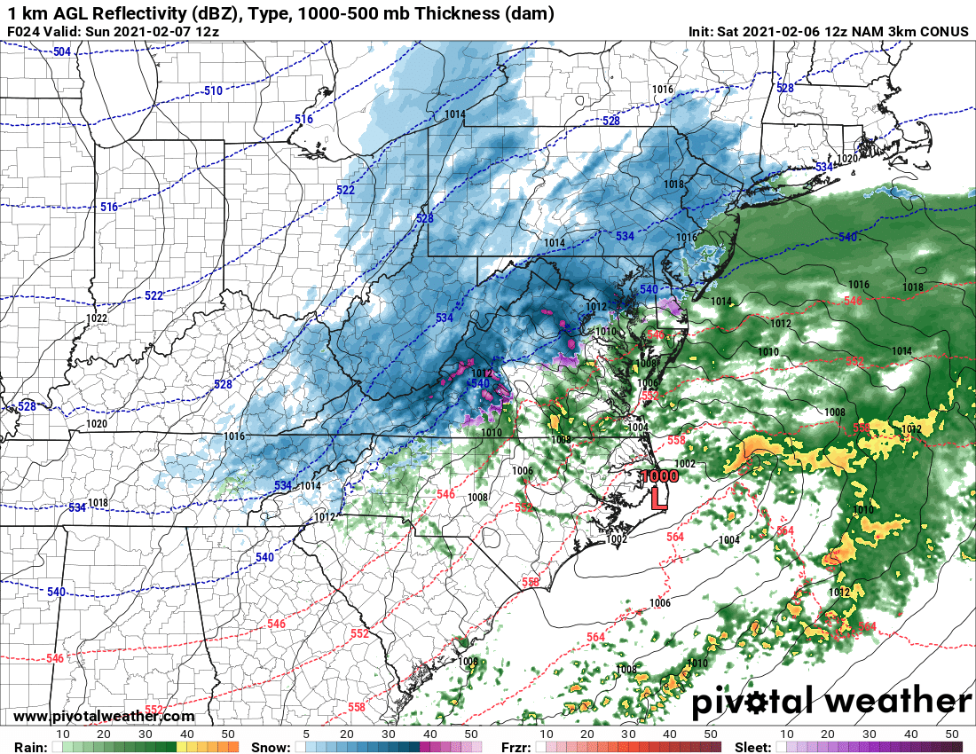
With its lower resolution, the NAM parent just generates a nice uniform swath of snow through the area, but the higher resolution nest clearly indicates some impressive bands, justifying the idea that there will be winners and losers.
-
That's an ugly map, but the QPF has 0.5" running right through DC, so I think it's just a little too warm in the low levels for more snow?
-
If I had to guess, I'd go with it being a blip, but it sure revs up the heartburn when you see shifts in a setup with so little margin for error....
-
If we're really worried about the GFS, it's worth noting that 5 consecutive GFS para cycles (through 12z today; 18z has not yet updated) were wetter and snowier than the operational. There are no zoomed in graphics, but you can see the key differences pretty clearly (use the dprog/dt option): https://www.emc.ncep.noaa.gov/users/meg/gfsv16/realtime/gfsximages.html
-
As you noted, there are 3 Hi-Res Windows: ARW, ARW2(NSSL-WRF), and NMMB (some sites still incorrectly label it as NMM). NMMB overall performs the worst and will be retired and replaced with a Hi-Res Window FV3 around May. I agree that they're just not great for winter storms - they are much better for details with severe weather and flash flooding events.
-
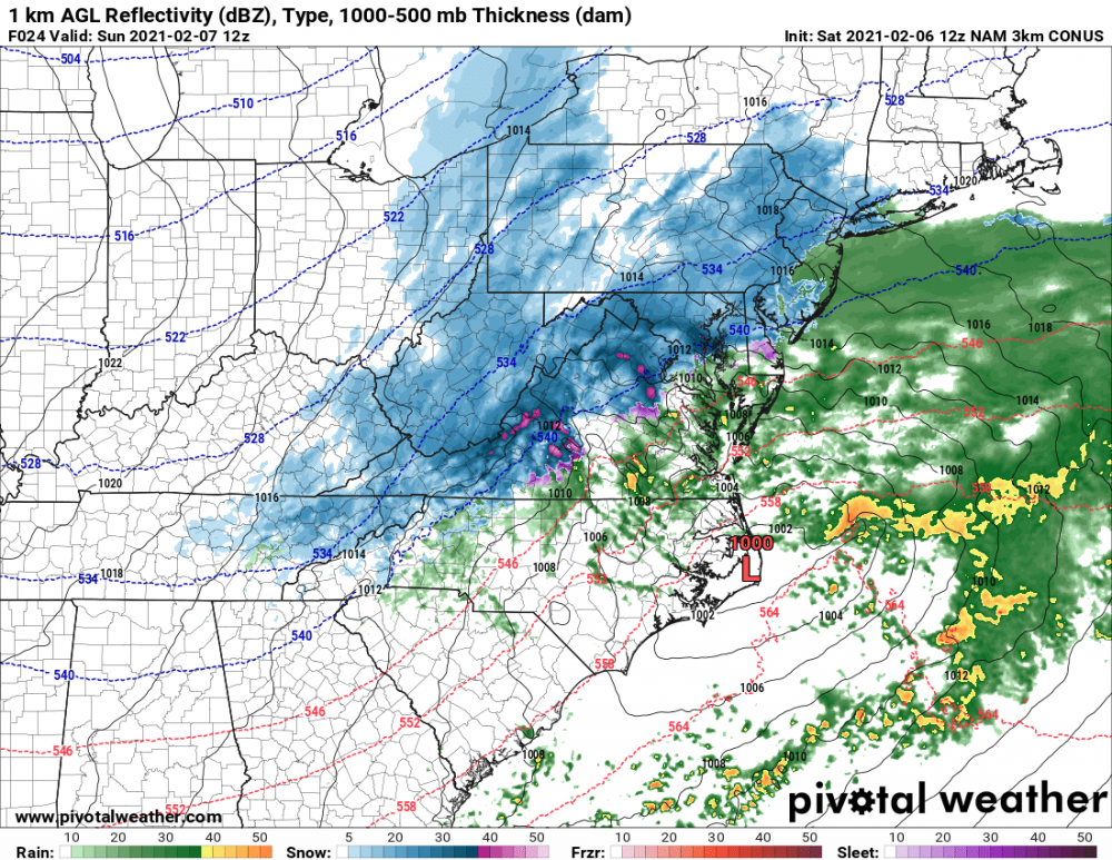
I really expected the nest to bury us with the further west track, but it looks like it doesn't close off things at 850 until a bit too late for us. It's a nice hit for sure, but we end up with a bit less than the parent which had the sfc low further east but closed off at 850 sooner..
-
NAM nest again considerably further west with the track of the sfc low edit: despite that, most of the region still stays snow
-
NAM nest has the sfc low much further northwest, and that's bad for southern MD snow weenies. It's still great for the I-95 corridor, but I can't help but be a little nervous about one more tick to the northwest ruining the party for more of us.
-
Definitely derived by the individual map providers. There is no SLR output from any NCEP model. In fact, the only system that even produces a true snowfall accumulation in inches is RAP/HRRR. The others all generate snow water equivalent (for which the provider applies a ratio) and snow depth (closest thing to a true accumulation, but derived from the land-sfc model).
-
I have been one of the loudest proponents for looking at the snow depth maps, but that is because most events have a big area of sleet or mixed precip, and the 10:1 maps are horribly inflated since sleet gets tallied with snow into the snow water equivalent. This is a setup in which I would NOT advocate the snow maps for 2 reasons 1) this is mostly a rain or snow event with probably only a small band of sleet somewhere to our south, so 10:1 (maybe mentally lower it by 10-15% or so) map should be ok 2) snow depth maps are underdone in events with marginal temperatures and with warm temperatures the day before which warm the top soil layer. The land-surface model sees 33 degrees and warm soil and says "well, this is going to struggle to accumulate", not accounting for the fact that big rates can overcome those negatives.
-
Two contributors to the snow hole: 1) most of the snow to our north falls early tomorrow morning 2) if you look closely at p-type maps, there is a little area of rain right over DC and just south and another over the northern Chesapeake Bay early Sunday The urban heat island effect (which is overaggressive in the GFS) and warm waters, with a marginal air mass in place and weaker precip rates, are contributing to the rain.
-
That's my take too. Definitely a weaker shortwave, which dampens the ridging out ahead. I don't think this will be as good as the 18z NAM, although I don't *think* it will be awful either.
-
I should have said "late spring", as April or May seems far more likely. WAY too much SREF talk in here this evening........
-
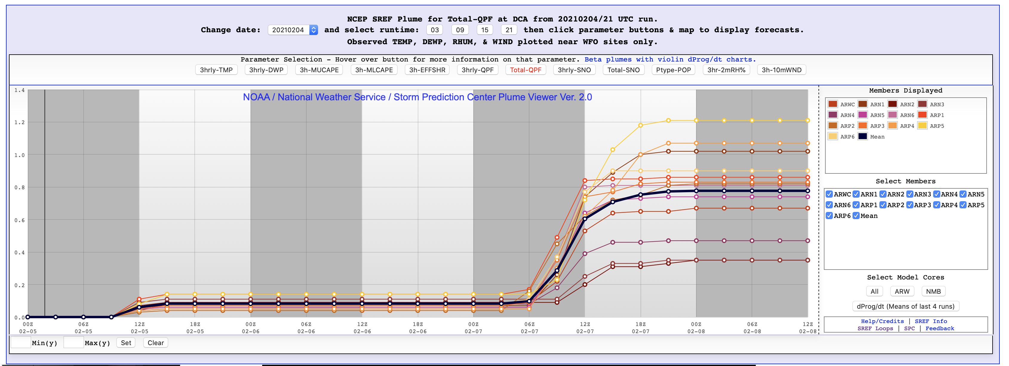
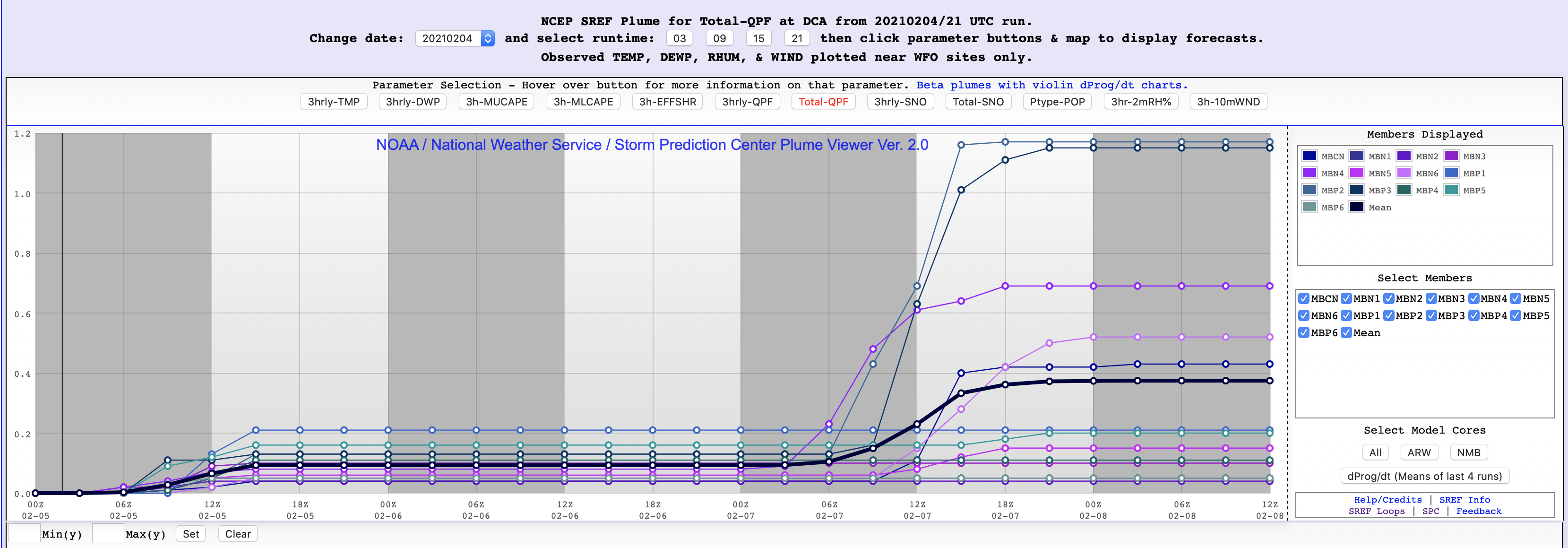
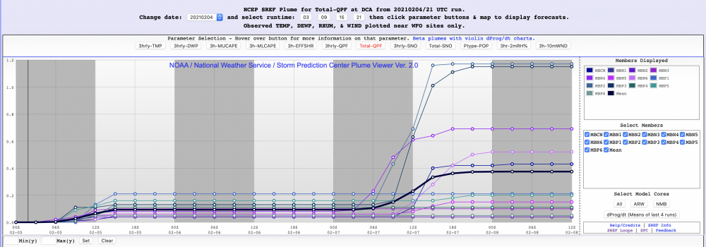
here's exhibit A for what I was mentioning about the two camps of SREF members. For the upcoming event, the ARW member are amplified, and the QPF is rocking' For the NMMB, there are a couple of exceptions, but they're mostly light, suppressed events:

-
The SREF was a good idea, as it mixed and matched two different model cores, initial conditions from three different systems, and different physics. It's really, really tough to get meaningful spread in the short range, so the approach was smart, but the problem is that things were never successfully tuned. You have 26 members, but you often get two camps, with clusters for each of the two cores. The ARW members tend to be very amplified, and the NMMB members tend to be flat. The middle ends up being ok-ish, but you could get the same answer with just one member from each of the two cores. But I agree that it shows the general range of possibilities. The SREF will be turned off once it is established that the GEFS can cover the short range, as AWC and WPC still use the SREF. HREF simply blends the NAM nest and the three Hi-Res Windows. Version 3 (coming this spring) includes the HRRR too, and the Hi-Res Window NMMB member gets replaced with an FV3 member. It's only as good as the models that comprise it, and there are shortcomings as Millville noted, but it scores quite well. It will serve as the baseline for the new Rapid Refresh Forecast System (hi-res, 10 member, hourly FV3 ensemble) which is probably ~3 years away.
-
Yeah, this morning's AFD from LWX is NOT aging well.....
-
Feb Long Range Discussion (Day 3 and beyond) - MERGED
high risk replied to WinterWxLuvr's topic in Mid Atlantic
Important note: The Euro run total maps include some snow tomorrow morning, including some for the northern part of this sub-forum. -
Feb Long Range Discussion (Day 3 and beyond) - MERGED
high risk replied to WinterWxLuvr's topic in Mid Atlantic
Absolutely. The last 4 cycles have all ticked to the northwest with an axis of moderate snowfall.