high risk
-
Posts
3,151 -
Joined
-
Last visited
Content Type
Profiles
Blogs
Forums
American Weather
Media Demo
Store
Gallery
Everything posted by high risk
-
Curious 18z GFS evolution for the Thursday wave
-
I could tell you what its Critical Success Index value for 24h snowfall at Day 3 is, but what would you do with that number? For the most part, it’s as good as the inputs it uses, but the operational version right now is running high, because it’s bias correcting QPF upward based on a very limited sample of recent significant QPF events in the very dry Mid-Atlantic.
-
So, you don’t actually know that. The winter part of the NBM at this range only includes the NAM, GFS and its ensembles, and the Euro and its ensembles. The para includes some of the Canadian system as well.
-
Just some speculation that this cycle will NAM the crap out of us.
-
If you liked that GFS run, you're going to LOVE the 18Z NAM Nest on Saturday.
-
Stats are generated, but the comparisons are to the WFO forecast grids, since the NBM is the starting point. It generally scores well if the input models are doing well; it performs bias correction, but that has limitations.
-
It's not really a retirement. It's an upgrade, just like is done routinely with models. Goal is to live in April.
-
The NBM does not use Kuchera. It uses a mix of different SLR techniques.
-
I recommend using the parallel for the winter stuff - it's much improved for those products
-
The issue is that any regional model is likely to struggle beyond Day 2 due to the influences of the boundaries. People love to punch the NAM, but a lot of good mets realize that the NAM Nest can do some great things inside of Day 2. I suspect we're going to find out the same for RRFS......
-
The bigger issue is that the critical wave is near the western boundary of the HRRR.
-
quick NBM comment: thrilled to see lots of NBM images, but it should be noted that the parallel NBM is about 3-5" lower with snow totals in the local area. The issue is that the QPF feeding into the winter suite is bias-corrected based on the forecasts and observations over the past 3 months, and it has been very dry here. As a result of the training sample having few high QPF events, the bias correction breaks down a bit, and for this case, it is boosting the already high QPF amounts even higher. The parallel has some changes to prevent seeing this as an extreme event, and it is not adjusting the QPF upwards like the ops. To be clear, the para still has a major event for us, as it should; it's just not in the HECS category.
-
One other thing to note is that the para gives more weight to the CAMs in the short range, so it will be really fun to see what this event looks like as get closer to it happening.
-
Not fully true. While the time it starts doesn't match the operational, the actual cycles of the parallel use inputs from the same model cycles as the ops. Worth noting that the ops does not include any Canadian inputs in the winter suite, while the parallel uses several. And a reminder for everyone: both the ops and para winter products only update at 01/07/13/19z.
-
It's not "new" per se; it's just faster on both the GFS and AIGFS.
-
Nope. The winter stuff updates at 01/07/13/19z.
-
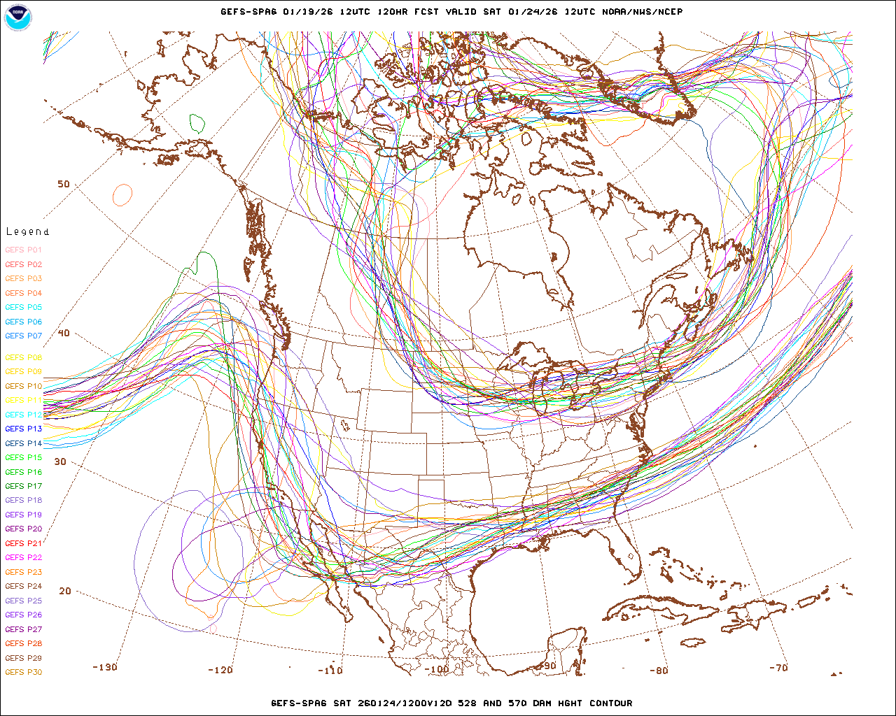
First, remember that the GEFS is now 31 members. I think there were dissemination limitations that prevent all members from being sent to various servers, but the 20 displayed in that image are only a subset. That said, there are certainly a bunch of GEFS members that are duds, but my guess is that those are the ones that keep the cutoff stuck in the far Southwest. Certainly limited support for that idea outside of the GFS/GEFS camp.
-
Doesn't really change the final result, the ECAIFS is notably slower with the arrival of the event on Saturday.
-
Yeah, it's not the biggest deal that this forum attributes late-arriving graphics on a downstream website to "the model is running late", but it ain't a bus stuck in traffic. These models run at the exact same time each day, and it takes close to the same amount of time each cycle for them to run. > 99% of delays are dissemination issues or issues at the sites generating graphics. The model itself is only late if it crashes or there are huge computer issues, both are which are exceedingly rare.
-
GEFS spaghetti shows that while some members do leave the trough behind in the Southwest, a lot of the members eject it eastward.

-
So, the question was whether the AI systems retain info cycle to cycle. They're independent cycles. One word of caution for everyone who is excited to see so many hits in the AI ensembles: the AI ensembles are very underdispersive on the whole, and this will be an area of research going forward. I would therefore advise caution when they show high probabilities of an event, as they can show high confidence in the wrong outcome.
-
FWIW, the AIGFS and ECAIFS runs this morning have some remarkable similarities in the Eastern U.S. for next Sunday, with a high-impact winter storm, even impacting our area. These two AI systems have been bouncing around a lot, so appropriate caution is warranted, but them both agreeing today catches my eye.
-
A round of snow later this afternoon for those east of DC is definitely not off the table. Even runs late Saturday showed a second round later Sunday afternoon - they just disagreed on how far west it would come. And there still isn't a ton of agreement on that......
-
One thing to watch for later today: The NAM and RGEM end the event by mid or late morning for everyone west of the Bay, while the GFS and some HRRR cycles have precip ending by late morning but then bring another round of snow for DC and points east later in the afternoon.
-
Seriously. I'm baffled by he expectation that we should lock in a solution at 240 hours and have every consecutive deterministic cycle not waiver in the slightest.