high risk
-
Posts
3,107 -
Joined
-
Last visited
Content Type
Profiles
Blogs
Forums
American Weather
Media Demo
Store
Gallery
Everything posted by high risk
-

2021 Mid-Atlantic Severe Weather - General Discussion
high risk replied to Kmlwx's topic in Mid Atlantic
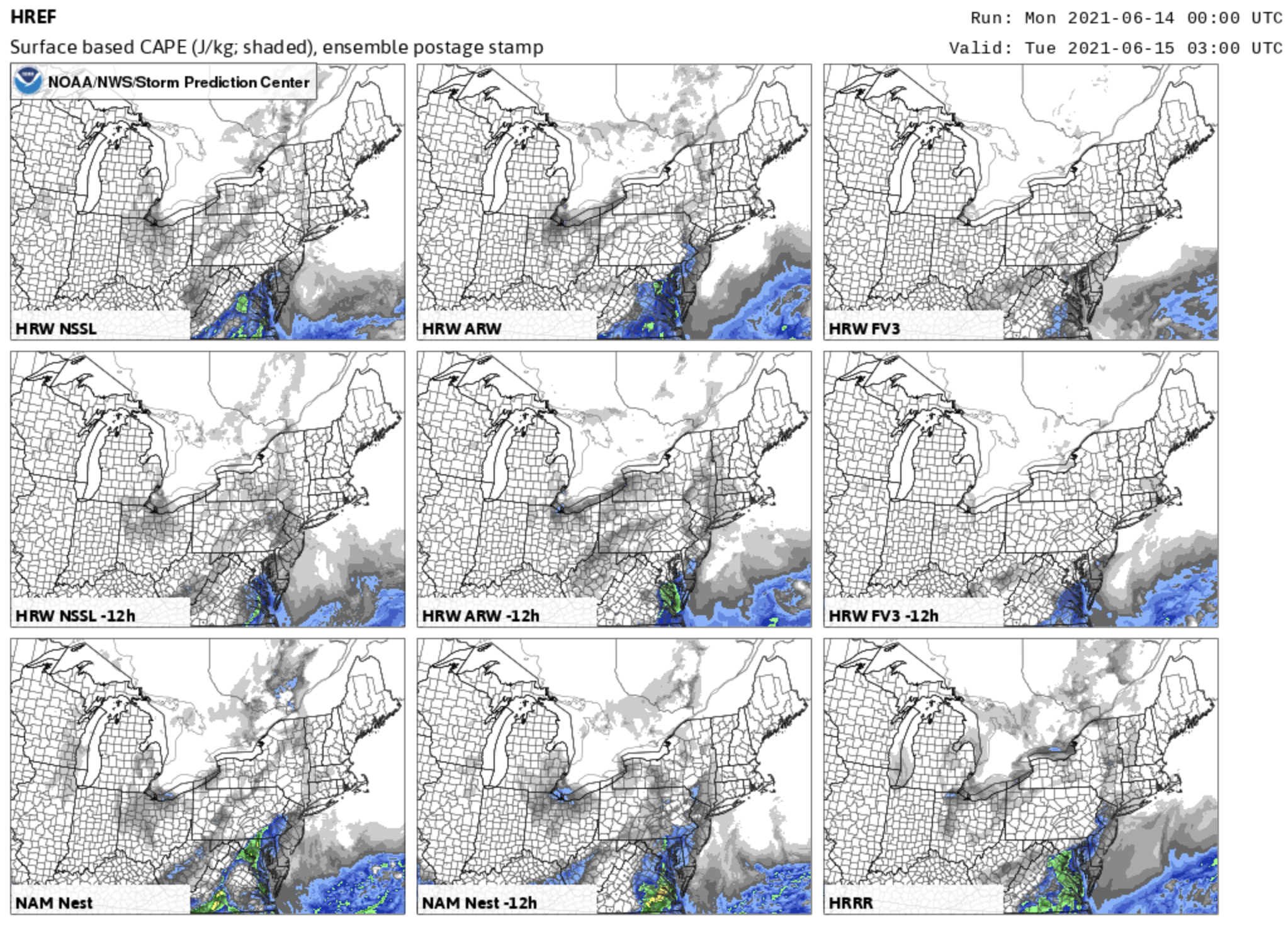
Yeah, things look better. I'm going to backtrack a bit from my earlier pessimism. There is a pretty clear trend in the guidance for some sfc-based instability to be present when the storms arrive/develop this evening. It shows up well in the individual 00z HREF member CAPE plots. The older runs (labeled -12h) have limited instability over our area, but some of the newer runs (especially NAM nest and ARW) trended higher with sfc-based instability last night. From what I've seen so far, the trend will continue with today's 12z cycle.
-
2021 Mid-Atlantic Severe Weather - General Discussion
high risk replied to Kmlwx's topic in Mid Atlantic
Hard to ignore that big UH track that the 00z HRRR showed, as you noted. I do think that the NAM nest is (as always) too slow; I'm still skeptical about whether even late-evening cells tomorrow can remain sfc-based, but I'll readily acknowledge that we have a shot. -
2021 Mid-Atlantic Severe Weather - General Discussion
high risk replied to Kmlwx's topic in Mid Atlantic
Right now, I'm not optimistic about SVR in the local area tomorrow, as the timing just doesn't look good. There are a few CAMs that break out a cell or two well out ahead of things during the afternoon, and any such cell could be SVR, but coverage will likely be sparse and perhaps non-existent. I'm on board with a sharp increase in convection here after dark, and we'll probably have a sweet lightning show. I'm just not seeing good sfc-based instability to take advantage of the stronger shear. Maybe it will find a way to get it done, but I'm so far not seeing any guidance keep surface temperatures from falling fairly quickly after sunset. Edit: two possible pieces of hope: 1) NAM nest has some convection in the early morning hours which could potentially leave an outflow boundary sitting around and lead to earlier initiation 2) HiResW FV3 has an earlier arrival of storms tomorrow evening, but it is somewhat of an outlier -
2021 Mid-Atlantic Severe Weather - General Discussion
high risk replied to Kmlwx's topic in Mid Atlantic
I remember that event well. It was just a couple of days after the historic May 31, 1998 northeast tornado outbreak (first ever high risk in that area), and another strong system came in on its heels. Moisture had been shunted south by the cold front on the night of the 31st, and there was a question of how quickly it would return here. SPC bought into the idea, issuing a MDT risk, but LWX wasn't buying it. As a recall, their discussions were very bearish, and we had only a 30 PoP in the local forecast. Dew points started the day quite low but ended up rebounding very well. Supercells erupted locally in the early evening. During my drive home, I could see a wall cloud over DC (cell phone cameras weren't a thing then), and I then got golf ball hail in northern PG County - the only time I've ever experienced severe hail in 25 years of living in the DC area. The big events were with the tornadic supercells to our northwest - there were early evening tornadoes very close to Pittsburgh and Buffalo among others in PA and WV, and the cells produced several late evening tornadoes in MD including the after-dark F4 in Frostburg. -
2021 Mid-Atlantic Severe Weather - General Discussion
high risk replied to Kmlwx's topic in Mid Atlantic
Two upcoming chances, but the timing looks off on both of them for most of us. The timing and coverage of late Sunday storms has a lot of spread in the guidance, but the best chances for SVR certainly do seem to be northwest of DC. The Monday system right now looks more impressive, as noted in previous posts, but it too may be arriving a few hours too late. -
yeah. definitely had heavier stuff within 2 miles, but I've been fortunate to get 0.02" The problem now is that the outflow swept through (and ignited the new storms just south and west), so I'm stabilized in the short term. Not giving up on the afternoon, but I'm definitely concerned about getting left out. Hopeful for more widespread coverage later tonight.
-
getting a massive screw job here in southern Howard County. Tons of thunder from the storms to my north and east which are now redeveloping to my south and west
-
Pretty healthy after-dark uptick in convection across the area. Must be a shortwave approaching.
-
2021 Mid-Atlantic Severe Weather - General Discussion
high risk replied to Kmlwx's topic in Mid Atlantic
It could also be that new storms fire on the outflow boundary that is visible on radar moving south away from the current storms. That's the general idea that the HRRR is showing. -
2021 Mid-Atlantic Severe Weather - General Discussion
high risk replied to Kmlwx's topic in Mid Atlantic
The combination of instability and shear seems to be sufficient for a severe box here this afternoon, with the best focus for the those along and north of I-66 in VA and Rt 50 in MD. As noted by EJ, there is certainly a possibility of a few isolated supercell structures, as indicated by the UH tracks. -
2021 Mid-Atlantic Severe Weather - General Discussion
high risk replied to Kmlwx's topic in Mid Atlantic
I mean, it's not to going to be a day that we all talk about for years, but in a very tame severe weather season, it has the potential to be one of the better days so far. Looks like sfc-based CAPE in the 1500 range with modest shear, and if you throw out the anemic NAM nest solutions, most CAMs do bring storms into the area later tomorrow afternoon into an environment that will support some wind reports and maybe an isolated brief TOR. For now, I'm less excited about Friday due to downsloping, but the inverted-V soundings do support wind potential if storms can organize. -
2021 Mid-Atlantic Severe Weather - General Discussion
high risk replied to Kmlwx's topic in Mid Atlantic
Yeah, shear will be increasing later tonight, but there just isn't any instability to get a decent updraft. Even west of the Blue Ridge where "instability will be surging north", sfc-based CAPE values by early morning will be only a couple hundred J/kg at best. -
2021 Mid-Atlantic Severe Weather - General Discussion
high risk replied to Kmlwx's topic in Mid Atlantic
Nothing I've seen this evening has tempered my cautious optimism for Thursday. Good convective signal across the CAMs with modest instability and either respectable or even good low-level shear (depending on your model of choice). Not sure there is enough for a day 2 ENH, but I expect the overnight update to at the least maintain the SLGT with a 5 TOR probability for our area. -
2021 Mid-Atlantic Severe Weather - General Discussion
high risk replied to Kmlwx's topic in Mid Atlantic
Definitely a good SVR day for this area, but none of the tornadoes was particularly strong. I remember leaving work early to get home before things got bad, and the cells had some nice signatures but nothing with major impacts. -
2021 Mid-Atlantic Severe Weather - General Discussion
high risk replied to Kmlwx's topic in Mid Atlantic
It's actually going to help us by lowering LCLs and allowing the circulations to more easily reach the ground. (But yeah, that is the potential fail mechanism, although it still looks for now like we'll have enough instability to make things interesting) -
2021 Mid-Atlantic Severe Weather - General Discussion
high risk replied to Kmlwx's topic in Mid Atlantic
ride the hi-res window FV3 train, baby! -
2021 Mid-Atlantic Severe Weather - General Discussion
high risk replied to Kmlwx's topic in Mid Atlantic
No argument about that, but I have to say that I'm intrigued by Thursday's potential. Guidance right now shows favorable timing, a good trigger (lee trough), a respectable upper pattern, and good directional and speed shear in the lower levels. Instability could be better, as we won't have full heating, and the lapse rates are fair at best (but I've see worse). I'm going to be cautiously optimistic for now. -
2021 Mid-Atlantic Severe Weather - General Discussion
high risk replied to Kmlwx's topic in Mid Atlantic
Yeah, it does, although it tends to overmix and therefore move the warm front north too quickly. Will be interesting to see how far north sfc-based instability can develop this afternoon. -
2021 Mid-Atlantic Severe Weather - General Discussion
high risk replied to Kmlwx's topic in Mid Atlantic
I'm just about entirely out for tomorrow for those of us north of I-66 in VA and Rt 50 in MD. There isn't any guidance right now that brings sfc-based instability this far north. In fact, any severe threat is likely to be a good distance south of DC. Definitely expecting some elevated convection up this way, but we're going to end up on the cool side of the boundary. Not looking forward to the possibly low to mid 50s Saturday. -
2021 Mid-Atlantic Severe Weather - General Discussion
high risk replied to Kmlwx's topic in Mid Atlantic
That was the day several cells just north of I-70 interacted with the warm front there and produced several (low-end) tornadoes. -
2021 Mid-Atlantic Severe Weather - General Discussion
high risk replied to Kmlwx's topic in Mid Atlantic
Tomorrow has sneaky warm front potential for sure, as storms interacting with and just south of the front will be in an environment with very favorable hodographs. The question is where the warm front sets up. Right now, I'd definitely want to be south of DC (in line with the SLGT risk area), as I think it's going to be too stable at the surface for those of us north of town. -
2021 Mid-Atlantic Severe Weather - General Discussion
high risk replied to Kmlwx's topic in Mid Atlantic
had a bit of a downburst here in North Laurel. Had been heavy rain with very little wind, and the rain then went torrential with small hail and a huge burst of wind that took down some tree limbs and blew out a transformer in my neighbor's yard. -
2021 Mid-Atlantic Severe Weather - General Discussion
high risk replied to Kmlwx's topic in Mid Atlantic
HRRR is still by far the most aggressive model in mixing out the low level moisture. I'll be closely watching the dew points early this afternoon - if they fall into the upper 50s or lower 60s, I'll temper my expectations. If they stay in the mid or upper 60s, the CAMs with stronger, more widespread storms are more likely to be right. -
2021 Mid-Atlantic Severe Weather - General Discussion
high risk replied to Kmlwx's topic in Mid Atlantic
Yeah, they extended the 2% down here because a couple of HREF members have some very, very modest UH tracks. The afternoon storms probably have close to zero tornado potential, because as you noted, the shear is so weak. A window for a brief tornado might exist in the early evening if there is a round 2: the LLJ will strengthen a bit, and since it will have a westerly component, if the surface winds can back a bit near a leftover outflow boundary, a cell could briefly acquire rotation. If SPC had a 1% TOR contour, that would work just as well. -
definitely encouraged about getting meaningful rain at the end of the week, although I'd prefer to not wash out the entire weekend. The Euro is really slow to move everything out and would make for a pretty wet and ugly Sunday. The GFS has been more progressive, but the GEFS is clearly trending towards a wetter Sunday. Slow movement of the trough is key to a big rainfall event, as the totals for Friday night across most guidance aren't huge due to the better overrunning likely setting up to our north.