jbenedet
-
Posts
7,617 -
Joined
-
Last visited
Content Type
Profiles
Blogs
Forums
American Weather
Media Demo
Store
Gallery
Everything posted by jbenedet
-

It was a Flop... February 2024 Disco. Thread
jbenedet replied to Prismshine Productions's topic in New England
Allow the multi-day torch to commence. Exceed average daily high by 10 am kinda day. 45 is a lock for PSM. 47 my bet. +12 -
It was a Flop... February 2024 Disco. Thread
jbenedet replied to Prismshine Productions's topic in New England
I was driving through Andover MA this past weekend and saw a field of broccoli heads coming up. Had to triple take it…. That’s at least a month early. -
It was a Flop... February 2024 Disco. Thread
jbenedet replied to Prismshine Productions's topic in New England
Yes that’s another good point. By this time of the year, for buildings/homes that get good sun, you’re def using less heat at 35 and full sun than 45 and clouds. And yea does a lot to improve your day to day sentiment in the heart of winter. -
It was a Flop... February 2024 Disco. Thread
jbenedet replied to Prismshine Productions's topic in New England
Not really. By feb, 35 and full sun is like 45 real feel; can even feel closer to 50 in city scapes, if wind is completely calm. Also does a lot to brighten things up—lower absolute humidity levels in winter and no vegetation maximize ISR in the biosphere, right at the surface. -
It was a Flop... February 2024 Disco. Thread
jbenedet replied to Prismshine Productions's topic in New England
Only because the snow maps weren’t producing much at all for New England. -
It was a Flop... February 2024 Disco. Thread
jbenedet replied to Prismshine Productions's topic in New England
Looks more like late November than early February. And this is before the warmup this week in the northeast which will push the pack line back to Winne. Wouldn’t use early feb climo with snow pack and SST’s up here… Better use a significant + surface temp bias in SNE or risk getting burned.
-
Did you say geese?
-
It was a Flop... February 2024 Disco. Thread
jbenedet replied to Prismshine Productions's topic in New England
That’s what makes a rat in this part of the world -
It was a Flop... February 2024 Disco. Thread
jbenedet replied to Prismshine Productions's topic in New England
Big snows will always be close in Dec and Jan, we live in New England lol. I def would not feel good about a forecast on that merit. -
It was a Flop... February 2024 Disco. Thread
jbenedet replied to Prismshine Productions's topic in New England
The outcomes to date have been pretty damn textbook significant El Niño. Just following that seasonal forecast would have yield great accuracy results to date -
It was a Flop... February 2024 Disco. Thread
jbenedet replied to Prismshine Productions's topic in New England
That curious look for the cold shot this weekend with massive ridge in plains and trough in the northeast is going to continue to flatten out It looks very MJO phase 6ish. Notorious lag, i know but we've been in phase 7 and will remain so into the weekend. Sell BN. Think good chance it turns out AN both days. Likely really nice for early feb.. -
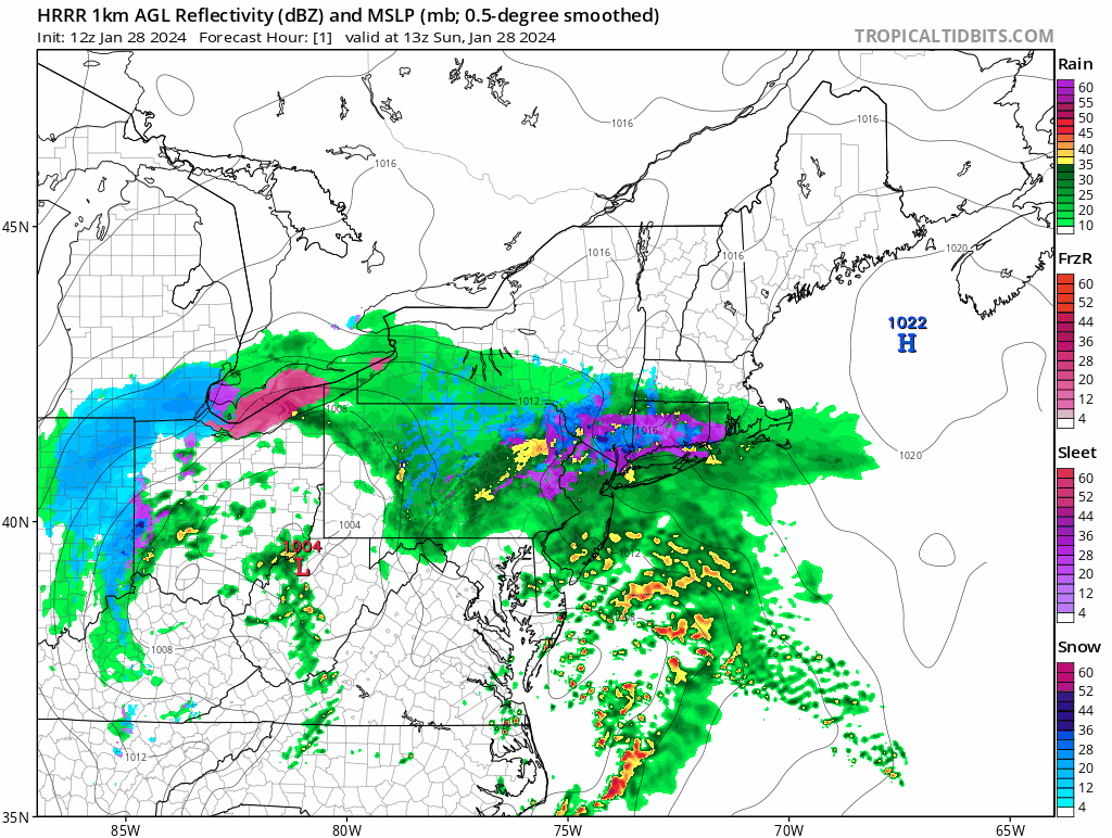
The banding was good enough for 6" to the sea coast NH down to- Newburyport MA/Lawrence. But temps a huge limiting factor throughout. Pretty cool driving from Dover to DAW and seeing snow amounts triple in ~8 miles.
-
Kinda wild hearing the melting as the rates drop to light, and temps bump up a degree or two.
-
Solid heavy band over. Looks like coating on driveway. Maybe cold surfaces are half an inch.
-
Way too much of this white rain has been registering as snow on these algorithms. That’s the only reasonable explanation.
-
Radar looks good in northern mid Atlantic but that’s decaying as it swings east, and the mid levels open back up. Misconception to think that whole structure swings through tonight in that same state. It’s also going to speed up. I feel like 2” is optimistic scenario here; and most likely outcome is a coating.
-
Plain rain. occasional flake. 37/35
-
Really warm in CT where dry slot has moved in. Temps approaching 40. Wow.
-
Those areas that dry out are probably going to warm up to mid 30’s, before temps fall again in the evening Very early spring like.
-
I think part II is the focus for just about all except northern berks and southern VT, which cash in on both. Part II will produce in most areas but she’s going to be racing east at that point, so expectations need to be low, especially with BL temps hovering at/just above freezing throughout.
-
BDL: 37/35 woof.
-
NAM just toying with snow weenies. Breaking their hearts.
-
Yea this is all effed down there.