

jbenedet
-
Posts
6,565 -
Joined
-
Last visited
Content Type
Profiles
Blogs
Forums
American Weather
Media Demo
Store
Gallery
Posts posted by jbenedet
-
-
The precip rates will be impressive with the initial push Wednesday evening. But radar echoes will progressively weaken after 0-6z Thursday. Lots of “holes” developing in the echoes.
For the big totals you’ll need to be stacking Wednesday, and that’s when temps are most marginal in eastern sections.
-
 1
1
-
-
The depth of the ULL peaks 6z Thursday near *Indiana*. It’s weakening from there on out.
I think what we’re missing more than anything with this is another UL vort to phase in as it makes closest approach to us.
Decaying low isn’t gonna get us the consistent mod+ rates to stack in the marginal areas in SNE and SE NH.
-
2 minutes ago, DomNH said:
Problem with those GFS clown maps in this area is that most of what falls after 12z Thursday, if it’s even snow, probably isn’t accumulating much, especially on pavement. Heaviest rates are Wednesday night into Thursday which could bring a few sloppy inches but anything after that I’m skeptical. The snow depth maps aren’t all that impressive outside of the elevated areas.
East winds are ripping in eastern SNE up to PWM. SST’s are low 40’s in gulf of Maine. It’s not until after 12z Thurs that those areas gain a more northerly component and by then our ULL has really filled in and dynamics therefore significantly weaker.
-
2
-
-
Just now, HIPPYVALLEY said:
Maybe with that saturated ground you get some gusts that rip a few trees down.
6 trees and 6” of rain. The new persistence forecast.
-
 2
2
-
-
Another early H5 occlusion….

-
Evolved into a look that favors West more than north (ex interior Maine). I like Scranton PA area and a big chunk of upstate NY from Binghamton up to Albany NY —much more than southern NH.
-
1
-
-
42 minutes ago, dryslot said:
Quite bullish on the 06z GEFS

That’s a white rain goose egg in SE NH. PF has it right with the depth change maps. Much better baseline with that.
GFS gonna burn us on the coast up until go time with these looks.
I mean, it’s outputting 32-34 DP throughout, with 34 surface temps over same time frame. Assuming that’s correct you’d have melting exceeding rates with the qpf output. And if it’s 3 degrees too cold (as the GFS has been all season at these leads) it’s wet surfaces except for the coldest with those transitory dustings that melt whenever rates lighten.
Seeing that 34 DP 18z Thurs on the backside of this <980 low is red flag we don’t have the cold conveyor hook up needed to positively offset “marginal”.
-
2
-
-
Rain in Portsmouth NH
34/31
-
1
-
-
100% sleet. Maybe had 3” before change.
-
1
-
-
Wrt SNE - whole thing synoptically looks like a rainstorm. More like a potent frontal wave riding a cold front NNE over eastern New England; no cold conveyor. I mean, the more I think about it this is fitting persistence perfectly, with 20% qpf to frozen, 80% rain to end in SE NH. Curveball was seeing this again in early spring. But then again our December to April 1st weather has been really more like continuous late March climo, in which case this also fits….
Snow boots remain in the closet…
.
-
 1
1
-
-
42 minutes ago, Damage In Tolland said:
Tippy.. here’s coming at you kid..!Just washed and waxed and shined tires and rims.
Merica’!

Missing the EU flag.
Stellantis. Oooof.
Because nothing says America like a parent company headquartered in the Netherlands, and > 50% of their employees in Europe.
-
12
-
 2
2
-
-
Away from the coast many areas in upper 50’s today. DAW and BED will push 60.
0z Friday GFS will be off by 10-15 degrees on a fair weather day in a good chunk of MA and SE NH.
All winter long….
-
2
-
1
-
-
First season since 2015 that I did not use the snow boots once all winter.
-
3
-
1
-
2
-
 1
1
-
1
-
-
That's a cool event on the cape. Blizz level. Memorable out there at least. Nice.
-
40 minutes ago, wxsniss said:
Congrats to those in southeast MA right now!
Feels like most areas of southern/eastern SNE have had some seasonal redemption with this storm. Boston metro a notable exception. Not even a consolation inch for this "snow emergency".
The "what happened" headlines beginning, with several met thoughts here, many saying they would have made the same exact forecast given the data until Monday afternoon:
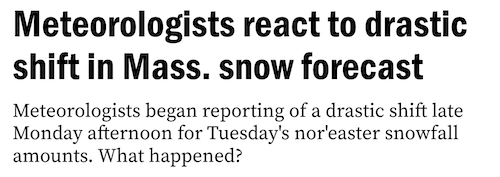
Eh. they shouldn't feel bad. Majority on here would have made same exact forecast through Tuesday afternoon.
-
1
-
-
-
1
-
-
1 minute ago, Sn0waddict said:
Impacts are being felt down to the coast, which certainly isn’t “rural” New England
"impacts".
What is this Maryland?
-
3 minutes ago, Great Snow 1717 said:
..almost up to 1/2 inch in Methuen!!!
@Damage In Tolland and @WinterWolf said you'd have 5" by now.
Hang on for the 12z euro snowmap. Maybe you'll see it there.
-
Rural CT only snowstorms are the worst. All the villageidiots posting snow pics like their backyard is happening everywhere.
Pretty sure there's a local brainworm problem in "drive thru" country of New England.
-
 1
1
-
2
-
3
-
8
-
-
2 minutes ago, Ginx snewx said:
Go back to bed
Some people actually work.
Go back to bingo.
-
1
-
-
For all the rejoicing from the clowns in CT about a positive bust. That's only happening in Hartford CT area out providence RI to ( their back yard--shocker), so far. The rest are busting low or on par with last night's paltry guidance.
-
1
-
5
-
-
6z clowns euro had 2" up to portsmouth.
Maybe 2 flakes, in 36F BL....
We won't see 2" down to Boston.
-
1
-
-
Temp going up on northeast winds. Nice
-
1
-
1
-
-
Shit storm. And the 6z euro ropes in more snow weenies on fringes just to break their fragile hearts.
-
2
-


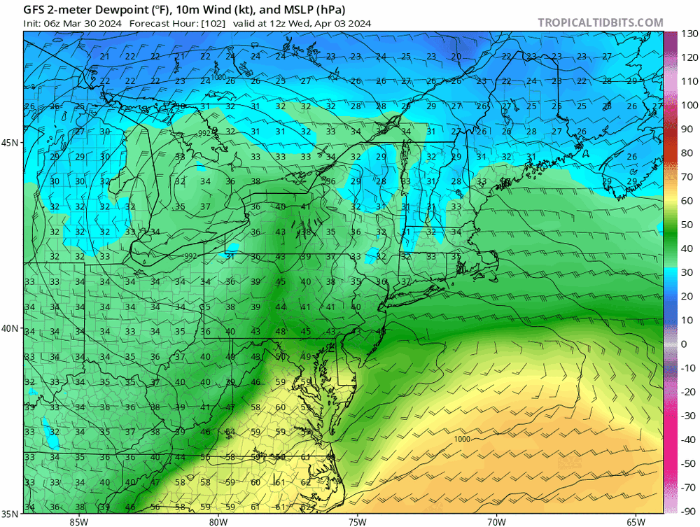
Significant Miller B Nor'easter watch, Apr 3rd-4th
in New England
Posted
Good baseline. Now from this reference point add 1-2F to surface temps throughout.
That's why I'm in much better agreement with NWS maps vs this output.