

Chris78
-
Posts
4,048 -
Joined
-
Last visited
Content Type
Profiles
Blogs
Forums
American Weather
Media Demo
Store
Gallery
Posts posted by Chris78
-
-
3 minutes ago, Ji said:
maybe the tuesday event is an appetizer for a hECS a few days later. Before some HECS, we would get an appetizer event right before it. FEb 2010, FEb 2003 come to mind lol. Totallly grasping at straws here but i would take 1-2 Tuesday if i knew bigger and better was coming a few days later
Gfs laughs at the idea
-
 1
1
-
 1
1
-
-
8 minutes ago, Terpeast said:
I don’t love the miller B look, which makes it possible for NW of DC to miss both upcoming threats. I’d be pissed if it happened
That's my concern lol. Tennessee valley sees snow on Monday. North East gets it next Friday/Saturday. We're in the middle.
I think there was some crazy 1400 hour snow maps that kind of looked that way a couple weeks ago.

-
 1
1
-
-
Just now, brooklynwx99 said:
overall pattern progression points towards a significant storm in the northeast. that's probably why
And hopefully the mid Atlantic.
-
1
-
-
Just now, Weather Will said:
WB 12Z EURO


Looks like they all agree for next Friday but can't agree for Tuesday.
-
1
-
-
51 minutes ago, CAPE said:
Frozen on frozen. Pretty rare. I'll take it.
I would lock that shit in right now if I could.
2 to 4 on Tuesday and 3 to 5 on Fri/Sat.
-
 7
7
-
-
10 minutes ago, LeesburgWx said:
Looks like we may be reeling this one in. Euro looks like GFS now with snow amounts. I’ll be damned. Those ensembles look beautiful too
Doesn't the 6z and 18z euro only go out to 90?
-
Just now, winter_warlock said:
All models are in line except euro... Euro is looking like a drunk uncle lol
Well. Only 4 days away now. Ud think euro would get more in line. Hopefully euro puts the tequila bottle down and joins the rest at 06z lol
Not sure I've ever seen this much of a difference between euro and gfs at day 4.
But not sure I've seen models jump so much run to run within 5 days
Lots of moving pieces for the models to nail down.
-
2
-
-
Just now, Maestrobjwa said:
Garbage or no it's showing a solution another main model is showing...something to watch.
Looks like the TPV is further SE compared to its 18z run.
-
1
-
-
1 minute ago, WxUSAF said:
It’s like 100 times better than 12z
Your right.
I guess 12z didn't really even have a storm.
-
2 minutes ago, Heisy said:
18z control bumped up a bit. This is probably what the OP would have generally shown outside 90hrs.

.Lol. That's awful
-
1
-
 1
1
-
4
-
-
2 minutes ago, psuhoffman said:
Oddly all the guidance at 12z kinda fell into their biases I've observed, GGEM/UKMET over amped, ICON progressive, GFS too far SE, except the Euro which was off on its own planet. Just an observation, not sure what to do with it.
Models are definitely having a hard time with all the moving pieces.
This might be weenie talk lol but it certainly seems like confiuence always ends up further north than advertised from Day 5+ on the models.
Would less confluence give us a better outcome?
-
1
-
-
Took this from the New England thread.
Certainly doesn't look like the OP.
Still a bit to Far East but much better than the OP
-
1
-
2
-
-
2 minutes ago, Bubbler86 said:
Glad to see the MA crew finally understanding the Euro control of the EPS is the lower resolution Euro. At least in what I read on the page from the group that manages it.
Euro vs the world .
Wonder who wins?
-
1
-
-
Euro vs the world.
I think I know who wins.
Always go with the least snowiest model
-
1
-
 1
1
-
-
Last night's Euro has heart break written all over it for 40 south. Late developing storm that doesn't get its act together till its at our latitude.
-
1
-
1
-
-
3 minutes ago, mitchnick said:
On another note. Idk if anyone has bothered to look at Enso forecasts for next winter, but this is the Canadian and the Cfs is similar. That's one cold equator.
Shut/Shit the binds enso
-
1 minute ago, Heisy said:
18z control is kind of odd at end of run. Just posting cause it tends to follow OP pretty closely and im bored.
Trough is really positively tilted. It almost looks like it was gonna dig and close off at the back end of the trough, which would have maybe allowed the front to clear first. Almost anafrontal…
Here is 18z eps as well

.The control certainly doesn't look the gfs with the tail end if the trough.
GfS much further east with it all.
I would say the Control was going to have a storm in the East with that h5.
Don't know if it would be a good track for us but plenty of energy left at the end.
-
1
-
-
18z gfs.
Cutter cutter suppressed suppressed suppressed suppressed again then cutter
-
1
-
-
2 hours ago, mitchnick said:
I think it's fair to say most are here for the snow. Even with that general forecast that matches strong Niños, many of those Niños had snow during warm months. I think it’s also fair to say that decent winter show themselves by now taking into consideration the date and forecasts for the next 10 days. If we're honest, this winter fails to have any characteristics of a decent/snowy winter. Using Bwi as my benchmark, if we/they fail the rest of January, which I would define as 2":or less for them and 4" or less here, we're looking at 94/95 and 97/98 as a viable strong Niño options. I'll stop right there.
I agree with your assessment. Good winters find a way to snow. This winter isn't shaping up that way. It's been very tough so far.
The next week is cutter city.
After that we have a shot. It we miss that then we're looking at late January early February.
I believe bwi is still at a trace?
Things can change quickly. It just takes 1 well timed storm but so far this isn't the feel of an above average winter.
-
2
-
-
16 minutes ago, Weather Will said:
Looks like we need to be worried more about suppression on the GEFS than a cutter for the 16th.
The only concern I have with suppression is if there's no storm lol.
Yesterday's storm was majorly suppressed till inside a week. On its way north we fell into the bullseye for about a day of model runs 5 days out.
-
Another perfect track rainstorm on the gfs
-
1
-
1
-
1
-
-
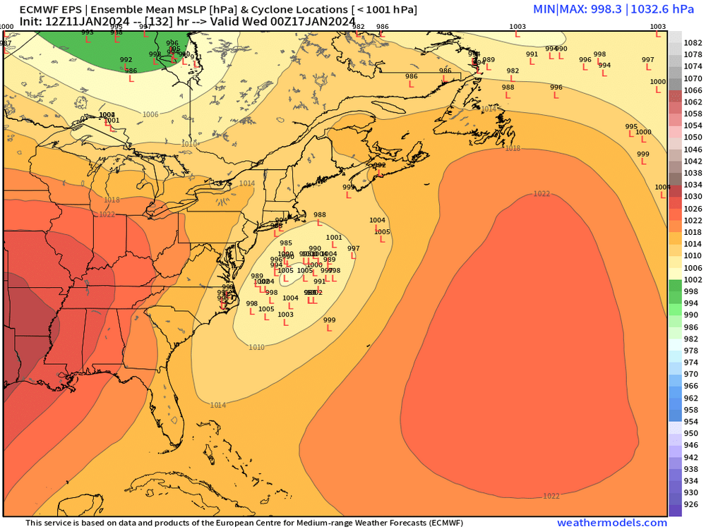
We're going to have to get through a couple cutters next week. After that there chances.
.thumb.png.70fbcaa0f0d994bd0007720d0ae3a345.png)
-
4
-
-
1 minute ago, yoda said:
Decent snowstorm on Day 9
We need that to be congrats Charlotte until day 4 lol.
But in all seriousness I think the 15th - 25th
Has alot of promise.
-
2
-
-
Ensembles are for insuring the OP isn't out to lunch not vice - Versa lol.
-
1
-
2
-


.png.048520b6c98f61f03feede7f5c49da4a.png)
Jan 15-16 Storm Threat Thread: Do we finally win or get Saltburned?
in Mid Atlantic
Posted
It's amazing it was Euro vs the world and EURO appears to have won.
Do you think if it was Euro with a snowy solution vs the world it would still win?