

Chris78
-
Posts
4,048 -
Joined
-
Last visited
Content Type
Profiles
Blogs
Forums
American Weather
Media Demo
Store
Gallery
Posts posted by Chris78
-
-
4 minutes ago, osfan24 said:
Doesn't matter at this point, but a 986 there isn't likely to die out quickly.
So far out and will be different in 12 hours but with the high position that's probably a decent front end thump.
-
1 minute ago, BTRWx's Thanks Giving said:
With the positioning of that low, I'll take it!
Thermals are trashed by that point.
Way to amped.
-
Seems like timing has sped up some. This was an overnight Satuday into Sunday deal. Looks like it mores of a daytime Saturday event now.
-
9 minutes ago, Terpeast said:
How are the thermals? I don't see much of a HP up north on that panel, so that strong of a signal makes me nervous about it being to warm for us (outside of the mountains)
It's dicey but the low track is as close to perfect as you can get.
-
 13
13
-
 2
2
-
-
1 hour ago, Weather Will said:
I LOVED the WB 18Z GFS for next Sunday, but the GEFS mean does not currently support the HH GFS. Until the GEFS mean or at least another major model shows the same scenario, expectations should be kept in check big time.


The EPS agrees with the 18z gfs.
GEFS is suppressed but most models agree there's going to be a storm in the East next weekend.
Hopefully we can nail down the details over the next 3 or 4 days.
-
9
-
2
-
-
Winter back on now.... in the long range thread
-
4 minutes ago, psuhoffman said:

Nice to see tenps cooler at 12z compared to the 00z run for the 7th.
-
1
-
-
2 minutes ago, CAPE said:
lol we know dude.
I would just like to see some effing snow lol.
It feels like it's been forever.
I just told my wife the other day I don't remember what it's like to have snow on the ground at night when it makes everything so bright out.
-
1
-
-
1 minute ago, North Balti Zen said:
I bump the futility thread each winter until I don’t have to. Was hoping to not have to have had bumped it this year but…already three bumps in.
Lately here our climate does feel more like Charlotte lol.
I have no idea if it's here to stay or just a rough period for cold weather but +8 anomalies are the norm now for December.
My yard is a swampy mess and some parts of it could be mowed lol.
I ussually make my last mow of the season shorter but what's the point anymore lol.
It's kind of crazy how few nights we've had below 32
-
Looks like winter is canceled now till the middle of February?

If we make it through this winter snowless BwI would be over 1000 days not recordng an inch of snow.
Now that would be something.
i think this board might implode lol.
-
3 minutes ago, Ralph Wiggum said:
I don't think this is all that horrible. Thumb ridge above Alaska with CPF coming around the back of the TPV near Baffin, pos height anomalies in nao domain, some SER to stop systems from sliding off the SE coast. That is a cold look with nowhere for stj moisture to come but N. Alright PSU, permission to 'roast' me
That's most likely a storm track to our west. Looks alot like the last several years.
I don't think PSU is exaggerating. It will take some time for the pattern to reload if that look is reality.
-
2
-
-
46 minutes ago, Ji said:
So the truth is…..deep down…no one thought this winter would be like this so far
The vision was
A cold late November early December with a snow window
A mid month warmup but not bad +2 at the worst but the pattern would be changing by Dec 20
Then our best chance for our white Christmas in years
A chance for a winter storm late December early January with the best of our Nino winter still ahead of us
40 inch winter on the wayI certainly thought by the first week of January we'd be cold enough if the storm track was south of us.
Honestly the entire temp profile is really disappointing so far
-
1
-
 1
1
-
-
4 minutes ago, snowfan said:
The suite of op guidance at range isn’t far off for temps…..GFS being the warmest. Canadian is by far the coldest but the storm is suppressed and never gets north of the VA/NC line.
Feels like a thread the needle type deal with temps.
-
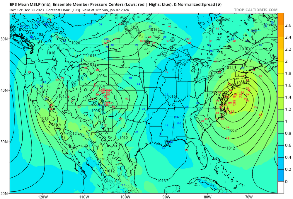
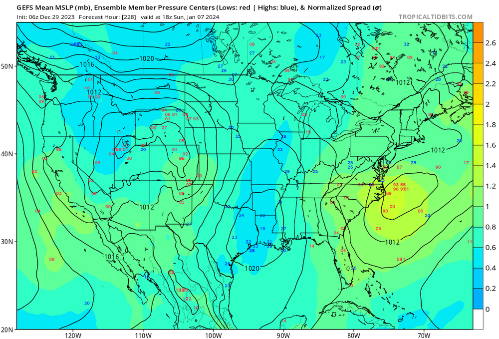
This is the best the GEFS has looked for thr 7th I do believe.
Just gotta hope there's enough cold air around.

-
10
-
-
4 minutes ago, psuhoffman said:
Again I need to preface this by saying I think it’s wrong. But I want to clarify the reason I say it’s “game over” in the off chance that’s how it goes.
I’ve been relying on a historical progression in a -pdo Nino with blocking. I got to that expectation by factoring in several variable to conclude the most likely result was a winter with blocking episodes combined with the current enso and PDO state. That progression has a historical pattern. So far we’ve been following that pattern. The way we’ve failed is very similar to past seasons that turned out good.
What the gfs is doing breaks that progression. It drops its back over its knees and then performs a suplex pile drive to it before breaking a chair over its unconscious body.
That is NOT how the pattern gets anywhere good. It’s a regression to the same base state that’s dominated. Frankly it’s not even similar to the “bad” ninos. It’s worse! And the gfs isn’t implying it’s a temporary thing it’s retracting the jet completely and building the same pacific death ridge we’ve had for 8 years!
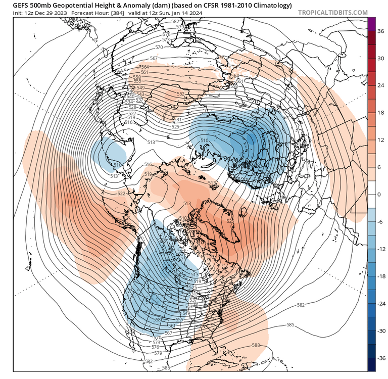
This look familiar….

It’s the mean long wave pattern of the last 7 winters!
Look at the GEFS…
We do not want to F with that. I have no interest in playing that game anymore. So in the event the gefs scored the coup here it’s over. That means even a strong bordering on super Nino wasn’t enough to alter the pacific base state some have been blaming on the numerous Ninas.
I think it’s wrong. It flies against all historical precedent. It’s in disagreement with the better ensemble guidance. It’s just 2 runs. So let’s just hope it’s wrong. Because if not its not the answer I wanted to my question.
We better hope the hell it's wrong. Looking at another snowless winter if it's on to something.
-
1
-
1
-
 3
3
-
-
7 minutes ago, clskinsfan said:
I am starting to agree with you. We just cannot get cold air on this side of the hemisphere regardless of enso. We'll see how the rest of this winter goes. But I fear we wont score much snow here anymore without bombs. And that is no way to chase snow.
I do think it's a red flag there's not much digital blue at all in the East.
When we are cold enough waves are shredded and when they Amp up we're on the warm side. Don't like seeing that on the models.
I know we should follow the Esembles but it's been days since an OP has shown us getting any snow at all. To me thars telling.
-
1
-
-
Sounds like we're punting most of January if we don't score something in the first 10 days lol
Worst hobby ever
-
2
-
 1
1
-
-
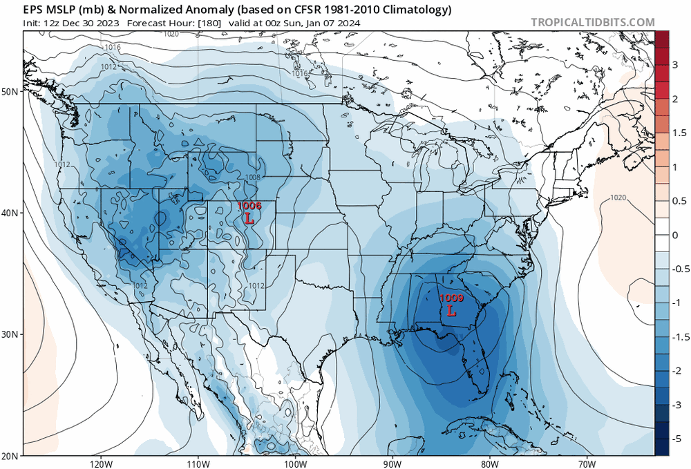
1 hour ago, CAPE said:
6z GEFS is even more impressive for the 7th wrt the surface low strength and frozen potential. Looks especially good along/west of the Fall line.
24 hr precip maps really juicing up in the south east. Hopefully we see some OP runs that show the potential also.
-
2
-
-
19 minutes ago, nj2va said:
So far TSSN+ and Heisy have called winter over/are out. The list will be 10+ long by Jan 1.
Lol Honesty though it does feel like snow is going to be hard to come by for a while. I try to stay positive but there does seem to be a disconnect. No storm and cold enough or storm but too warm. We shall see.
Going to deep creek to ski in late January. Can't count on snow around these parts. Gotta get my fix somehow lol.
-
3 minutes ago, Weather Will said:
If the GEFS has a discrete threat it is being very discreet about it....
I'm just going off of TT that doesn't have snow maps for Esembles but there definitely seems to be opportunities just looking at moisture and temp anomalies
-
Just looking at TT maps for GEFS and there seems to be plenty of Moisture south of us.
1/2, 1/4-5 1/7-8 seems like those are our 3 chances coming up with colder air available as time goes on.
Fingers crossed we can cash in on one if those..
-
4
-
-
1 minute ago, Weather Will said:
It is an operational run in fantasy land beyond Day 10, but there is no cold air....compared to yesterday's 12Z run. Zonal flow in Canada, no cold air moving south. Big disappointment if correct.


13 days out on an OP.
Come on man lol
-
3
-
-
10 minutes ago, Eskimo Joe said:
You've been 100% right so far. No reason to doubt you. We'll probably start seeing snowless winters and 65 degree Christmas days on the regular within the next 5 to 10 years.
Stockholm Syndrome. People can't believe it's happening so quickly.
We already are seeing snow less winters lol
-
1
-
-
23 minutes ago, Solution Man said:
Wow, Haymarket Va Weather.com 8 Jan. for giggles43°56%NW 7 mphCloudy with rain and snow showers early changing to mainly rain showers in the afternoon. High 43F. Winds NW at 5 to 10 mph. Chance of rain 60%.
-
Humidity61%
-
UV Index2 of 11
-
Sunrise7:28 am
-
Sunset5:05 pm
Mon 08 | Night
27°60%NNW 4 mphSnow likely. Low 27F. Winds light and variable. Chance of snow 60%. 8 to 12 inches of snow expected.
-
UV Index0 of 11
-
Moonrise4:48 amWaning Crescent
-
Moonset2:06 pm
JI runs that website
-


Jan Medium/Long Range Disco: Winter is coming
in Mid Atlantic
Posted