sarcean
-
Posts
251 -
Joined
-
Last visited
Content Type
Profiles
Blogs
Forums
American Weather
Media Demo
Store
Gallery
Everything posted by sarcean
-
Big change for Mooresville , NC (Lake Norman)! Now calling for 3-6 inches with the latest GSP forecast. Earlier it was an inch or so at most.
-
I’m near uptown Charlotte and hope I don’t totally miss out here.
-
I'm close to uptown (downtown) Charlotte and good size hail is falling
-
-
City of Atlanta under Tornado warning
-
2019/2020 Mountains and Foothills Fall/Winter Thread.
sarcean replied to Tyler Penland's topic in Southeastern States
The big snow will be tonight not the day today -
WWA advisory out of GSP: Alexander-Iredell-Davie-Catawba-Rowan-Cleveland-Lincoln-Gaston- Mecklenburg-Cabarrus-Union NC-Greater Caldwell-Greater Burke- Eastern McDowell-Greater Rutherford-Eastern Polk-Cherokee-York- Including the cities of Bethlehem, Ellendale, Millersville, Taylorsville, Hiddenite, Stony Point, Statesville, Mooresville, Farmington, Fork Church, Mocksville, Advance, Hickory, Newton, St. Stephens, Salisbury, Shelby, Kings Mountain, Lincolnton, Crouse, Gastonia, Charlotte, Concord, Kannapolis, Monroe, Trinity, Indian Trail, Weddington, Kings Creek, Lenoir, Sawmills, Granite Falls, Morganton, Pleasant Grove, Valdese, Marion, Nebo, Dysartsville, Fero, Glenwood, Forest City, Rutherfordton, Spindale, Tryon, Columbus, Mill Spring, Gaffney, Catawba, and Rock Hill 311 PM EST Wed Feb 19 2020 ...WINTER WEATHER ADVISORY IN EFFECT FROM 10 AM THURSDAY TO MIDNIGHT EST THURSDAY NIGHT... * WHAT...Snow expected. Total snow accumulations of 1 to 2 inches, with spotty 3 inch accumulations near the I-40 corridor, and amounts around 1/2 inch southeast of I-85. * WHERE...Portions of the eastern Upstate of South Carolina as well as the foothills and Piedmont of western North Carolina. * WHEN...From 10 AM Thursday to midnight EST Thursday night. * IMPACTS...Roads will initially be warm and wet, but with slippery conditions developing as temperatures fall through the day. The hazardous conditions could impact the evening commute. * ADDITIONAL DETAILS...Widespread black ice is expected Thursday night into Friday morning as temperatures fall into the 20s. PRECAUTIONARY/PREPAREDNESS ACTIONS... Slow down and use caution while traveling.
-
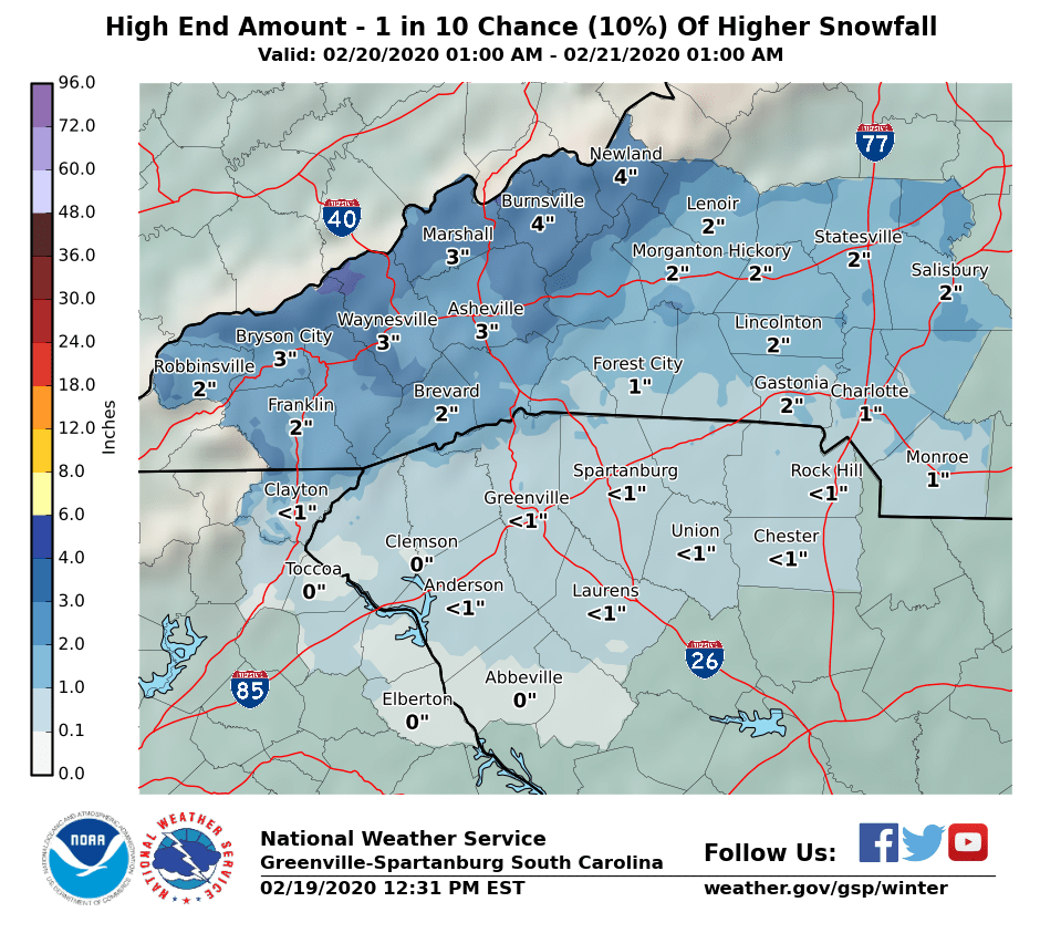
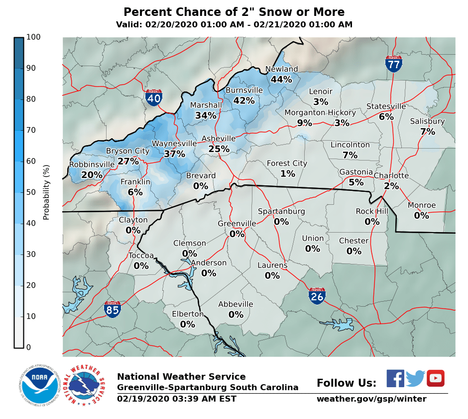
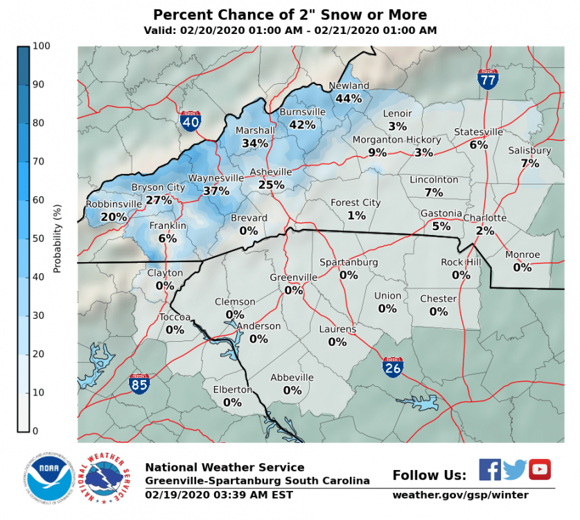
GSP is being very conservative...when the high amount (1 in 10 chance) is only 1" still for Charlotte

-
The models are going to move so much today, no reason to put in final call maps yet
-
Hard to put faith into a map that doesn’t even include a B on it
-
GSP is being quite conservative
-
Not the best look
-
I bet KGSO will cash in regardless but KCLT will have to deal with borderline temps
-
It's amazing we have the best models there have ever been and they still disagree so much this close to the storm. I was in Greensboro last winter for the 14 inch storm (and was in Boone the same storm when 2 plus feet fell) but kind of doubt anyone gets jackpotted like that. Would love to be proven wrong. Not holding much hope in Charlotte but a few inches would be great
-
Now give the same odds for Charlotte
-
Too early to say that yet. I think tommorows model runs will either make or break this for us.
-
You have to think of it like pure math If there is a 50-90% chance of it happening and only 10% of it exceeding that then you always do it for the more likely scenatio. The NWS knew it was a possibility today but it was didn't expect this rare scenario. It's a delicate balance since you never want to cry wolf.
-
If anyone deserves snow this season it's you after having so many fantasy snows vanish.
-
What’s the chance of Charlotte getting some decent flakes?
-
Some wild parts to the Forecast Discussion out of Greenville: "Changes happen in earnest late Wednesday afternoon as the forcing moves up from the SW and after sunset as the main surge of moisture arrives. Precipitable water values are expected to rise above 1.5 inches east of the mtns, with some guidance showing all-time high values late Wednesday night/Thursday compared to the climatology at FFC and GSO. Even more impressive are the moisture and water vapor transport anomalies during that time period, which are greater than 3 standard deviations and represent max values in the climatology. Periods of heavy rain are likely from late Wednesday night through Thursday evening as the atmospheric river translates across the region accompanied by strong mid/upper level forcing. There is the potential for 3-5 inches of rain by the time this system exits our region early Friday morning, with even more in the S/SW upslope areas of the mtns. A Flood Watch seems like a foregone conclusion with the scenario presented in the model guidance. However, the main threat will not ramp up until Wednesday night and there remains some uncertainty about the extent of the flood potential, so we will hold off with issuance for the time being. The other problem with be the severe thunderstorm potential, the details of which continue to remain elusive as guidance shows run-to-run inconsistency with the amount of instability. Everyone agrees that shear will be outstanding, on the order of 50-60 kt in a deep layer on Thursday and Thursday evening as a 60-70kt low level jet surges NE out of the Gulf. The GFS and ECMWF have backed off with their depiction of sfc-based CAPE, with both barely registering 100-250 J/kg. Meanwhile, the latest NAM develops better than 500 J/kg to the south of a boundary running along I-85 late Thursday afternoon, but the 03Z SREF shows very low probability of getting the CAPE above that level. Thus, the amount of instability continues to be a limiting factor. Suffice to say, the best chance for severe storms will be along and south/east of I-85, but will the mode be a QLCS with wind damage and isolated tornadoes, or will it be a large band of heavy rain with embedded tornadic supercells? The cold front should cross the region late Thursday and early Friday, bringing an end to the flood/severe threats. Moisture wrapping around a frontal wave will keep precip chances along the TN border into at least Friday morning, while colder air moves in from the NW. Precip will change to snow showers in the upslope areas along the TN border, with some potential for a minor snow accumulation at high elevations. This activity should wind down by sunset on Friday."
-
we had a good 10-15 minutes of a nice heavy snow shower in Uptown Charlotte. Hope that is not in for the winter...
-
Fresh in my mind is Greensboro receiving officially over a foot (which was really 15"+ in many areas) in a snowstorm last season with Winston 14.5". Sure the rest of the winter was mostly quiet but it was the third snowiest day in Greensboro history. Lets not act like central NC hasn't gotten anything in a while.
-
Correct me if I'm wrong but Raleigh is normally quite conservative to call for snow so I think its big they are so bullish on this storm so far
-
Have to feel pretty good in Greensboro when the official NWS forecast is: Saturday A chance of snow after 2pm. Cloudy, with a high near 37. Chance of precipitation is 50%. Saturday Night Snow likely, mainly after 8pm. Cloudy, with a low around 31. Chance of precipitation is 60%. Sunday Snow likely. Cloudy, with a high near 36. Chance of precipitation is 60%.
-
isn't it about time to make a thread for it