sarcean
-
Posts
270 -
Joined
-
Last visited
Content Type
Profiles
Blogs
Forums
American Weather
Media Demo
Store
Gallery
Everything posted by sarcean
-
year is young, might even have it tomorrow
-
Charlotte area is going to have a wild gradient between SC suburbs, Mooresville/Lake Norman, and Gastonia where a short distance will make all the difference
-
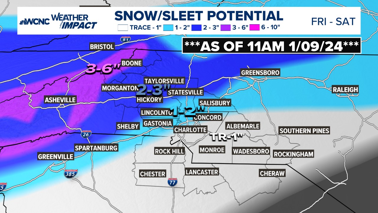
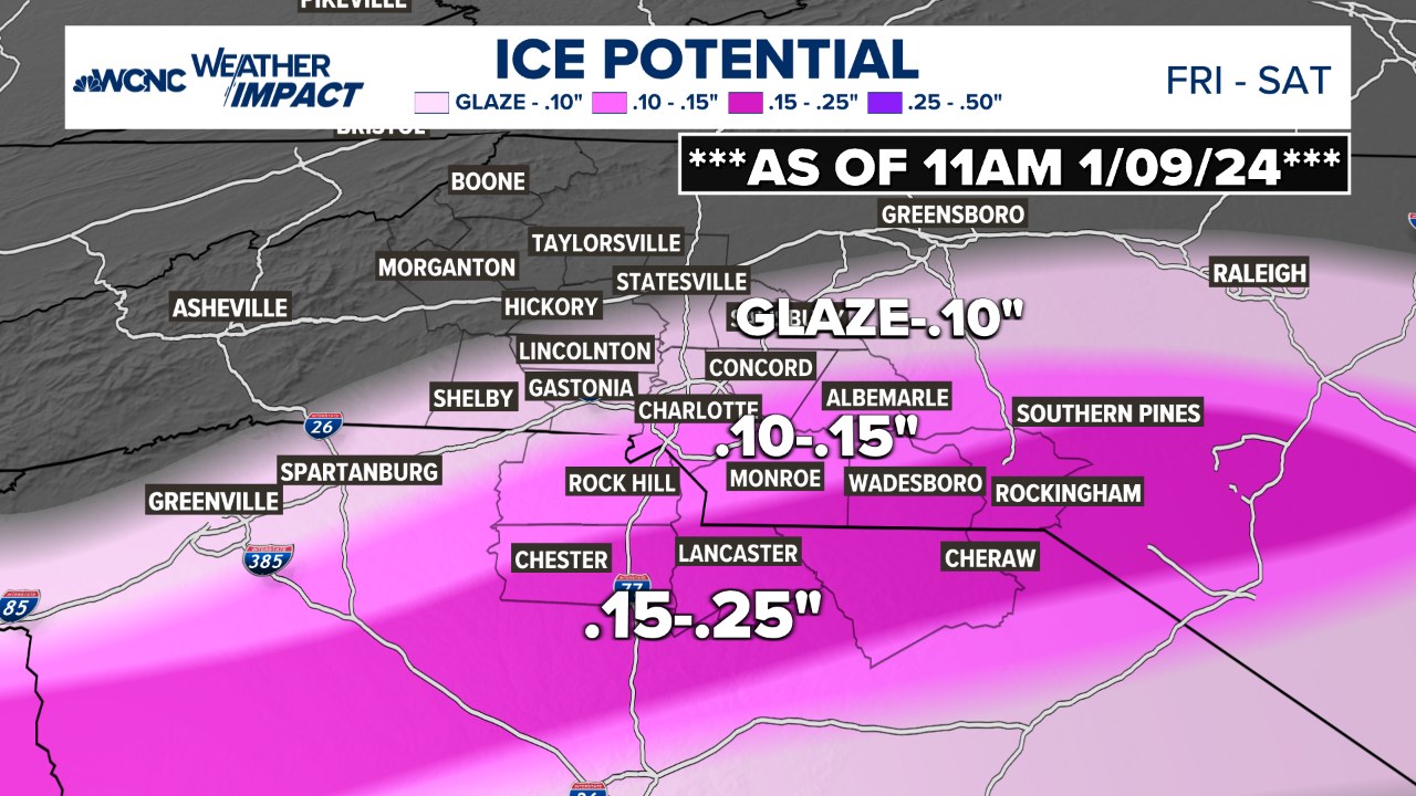
Issued: 3:03 PM Jan. 8, 2025 – National Weather Service ...WINTER STORM WATCH IN EFFECT FROM FRIDAY MORNING THROUGH SATURDAY MORNING... * WHAT...Heavy mixed precipitation possible. Outside the mountains, total snow and sleet accumulations between 1 and 3 inches and ice accumulations around one tenth of an inch possible. * WHERE...Portions of northeast Georgia, Piedmont and western North Carolina, and Upstate South Carolina. * WHEN...From Friday morning through Saturday morning. * IMPACTS...Snow and ice accumulations will make many roads treacherous and impassable. The weight of the snow and ice on tree limbs and power lines could produce scattered outages. The hazardous conditions could impact the Friday morning and evening commutes. PRECAUTIONARY/PREPAREDNESS ACTIONS... A Winter Storm Watch means there is a potential for significant snow, sleet, or ice accumulations that may impact travel. Continue to monitor the latest forecasts. Stay tuned to NOAA Weather Radio or your favorite source of weather information for the latest updates. Additional details can be found at www.weather.gov/gsp. &&
-
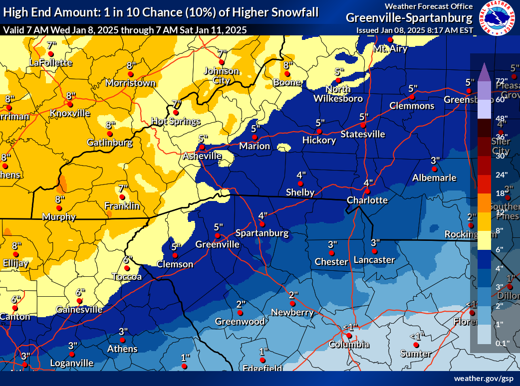
NAM is a joke with thermals - do not trust NAM for precip type...or amounts.
-
Charlotte area still scores there But can't remember the last time relied on a model like the UK to get a snowstorm right
-
Less than 3 days out and precip types and amounts are still wildly up in the air Just glad Charlotte will break it's streak of over 1000 days of snow
-
what a mess for the Charlotte area but hopefully it keeps (mostly) all snow
-
Not disputing RDU. Whether by city population, 482k (Raleigh) vs 911k (Charlotte) or metro (2.3 metro Raleigh vs 3.4 million), Charlotte is clearly bigger. Raleigh has many competiting cities with Cary, Durham, Chapel Hill, etc but Charlotte is much bigger. Hope for all us to score on snow.
-
Those are terrible odds for Charlotte and hopefully overdone. People rooting for Raleigh is over stated on this forum when Charlotte has more population and closer to the mountains. North of Charlotte (Lake Norman) is almost always guaranteed to score more.
-
2023-2024 Fall/Winter Mountain Thread
sarcean replied to The Alchemist's topic in Southeastern States
-
Atleast for Charlotte, historically the snowiest day on average is March 2nd Plenty of time to go
-
2023-2024 Fall/Winter Mountain Thread
sarcean replied to The Alchemist's topic in Southeastern States
Now 15" with 3 foot snow drifts at 5400' per Brad Panovich -
The trends don't look good. I don't think all the wishcasting is going to make this any sort of significant event for us. Ensemble support is quite low. Some may get some flurries and some end up with an inch but doesn't look like we can cash out on it since it is moving so fast.
-
Potential 1/28-1/30 2022 winter storm
sarcean replied to Prismshine Productions's topic in Southeastern States
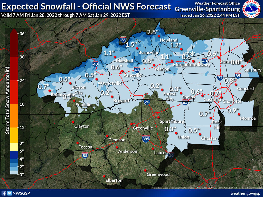
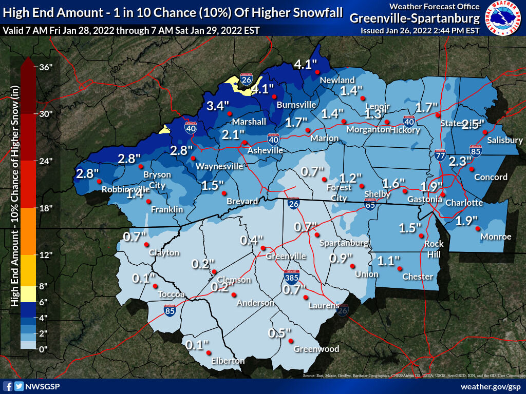
Charlotte is looking at 1-3 inches which I’m happy with. I don’t give much if any validity to what the NAM is showing. Somewhere East of Charlotte is going to get a nice band of heavy snow. -
Potential 1/28-1/30 2022 winter storm
sarcean replied to Prismshine Productions's topic in Southeastern States
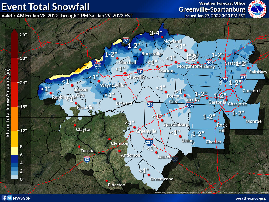
Thats a contrast with GSP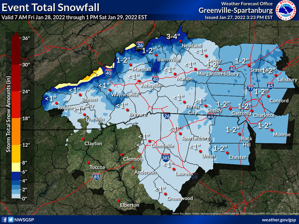
-
Potential 1/28-1/30 2022 winter storm
sarcean replied to Prismshine Productions's topic in Southeastern States
Love to see it -
Potential 1/28-1/30 2022 winter storm
sarcean replied to Prismshine Productions's topic in Southeastern States
If we some how in Charlotte pull 2"+ from this I would consider that a big win -
Potential 1/28-1/30 2022 winter storm
sarcean replied to Prismshine Productions's topic in Southeastern States
I remember being up in Snowshoe, WV for the Jan 2016 blizzard when they got three feet of snow. The first foot was great...it was after the second that it started getting ridiculous. -
Potential 1/28-1/30 2022 winter storm
sarcean replied to Prismshine Productions's topic in Southeastern States


-
Snowing great in uptown Charlotte! Maybe a couple inches on the ground.
-
January 20-22 “bring the mojo” winter storm threat
sarcean replied to lilj4425's topic in Southeastern States
No one has whines as hard as you on these boards. You will get snow. It may not be as much as some models had but the triangle is going to get over an inch to several inches which is a win anytime. -
January 20-22 “bring the mojo” winter storm threat
sarcean replied to lilj4425's topic in Southeastern States
Ready to cash out with that one


.png.31726778b50af279c819031b9818313f.png)
.jpg.5908e413b939705ce4e9179efd044c1d.jpg)