

stadiumwave
-
Posts
1,168 -
Joined
-
Last visited
Content Type
Profiles
Blogs
Forums
American Weather
Media Demo
Store
Gallery
Posts posted by stadiumwave
-
-
20 minutes ago, snowman19 said:
A few mets have opined that the -PDO/-PMM (extremely unusual) have muddied the MEI and we are also coming off a multi year La Niña cycle. We haven’t seen an event develop like this in a very long time, the MEI is biased towards more present events. I believe Paul mentioned that this Nino is similar to one we had back in the late 1800’s
Yes, but my point is he said the westerly wind event would cause the MEI to climb. It did not & he knew all about the problems with MEI when he tweeted it.
I see 2 things going on. Paul & several others are correctly pointing out this El Nino is stronger than the indexes would indicate but at the same time, almost all that they keep pointing to that will cause this to be reflected keeps failing to transpire. And this event continues to behave in ways they did not expect.
-
 1
1
-
-
15 minutes ago, bluewave said:
With the rapidly fading +IOD, it will be important how quickly we get a MJO 4-6 forcing rebound in December. The current GEFS and EPS have some forcing returning to the Maritime Continent in early December. We definitely want to see that muted or uncoupled.


Paul says those phases will be short lived.
-
2
-
-
2 minutes ago, bluewave said:
Humans are an extremely adaptable species. So even if the most severe climate scenarios play out, we will find a way to survive. But other species may not be as fortunate. That being said, most of the carbon emissions are now occurring in places like China. The US has actually slightly decreased emissions. Outside of technological innovations on our part, we don’t have any say in how other countries like China manage their emissions. So while our economies are still depended too on fossil fuels, we need to find innovations to adapt to a warming climate. It’s probably going to be a slow energy transition and my guess is that we are probably on track for at least +2C to +3C of warming since the industrial revolution. And possibly beyond that if we don’t start moving faster to find a technologies to transition between 2030 and 2050.
Roundy argues that the spike is a temporary blip. It's not a spike directly related to C02 which is more gradual. He explained it as this unusual El Nino event preceded by triple La Nina:
Paulshared Ryan's research about the 1877-78, which is arguably the strongest El Nino on record. Eric Webb has referenced this greatly in the past. Paul has as well.
I'm not good at going back through tweets but somewhere Paul explained the ocean heat release with this El Nino which he says is the most unique since 1877-78, indexes aside.
-
I know Paul Roundy explained how much the MEI index sucks but why did he tweet this back on Oct 24th? FWIW, he was wrong.
I'm not trying to knock Paul because I love that dude! But it kind of muddied his double down about how the latest weak MEI didn't matter.
-
1
-
-
Paul Roundy's take on the global spike needs to be here. The sky isn't falling.
-
On 11/11/2023 at 9:05 PM, 40/70 Benchmark said:
Well, no coincidence that my 10th annual outlook comes just 4 months prior to the 10th anniversary of my late dad's passing. The effort is dedicated to him. He would always ask me about the weather in an effort to redirect me when I was upset because he knew that was always a safe place for me. What I have learned is that while you can not cure addiction, you can adapt, and evolve in order to foster the insight necessary to redirect that energy away from destructive activities and towards more constructive channels.
That being said, I hope you folks enjoy the effort, as this place was an invaluable escape for me during some of the darkest periods of my life.
https://easternmassweather.blogspot.com/2023/11/winter-23-24-will-be-lesson-in.html
Great job! Great effort!
-
1
-
-
2 hours ago, GaWx said:
Here’s something for which I can’t recall the last time it occurred: every one of the 5 weeks of today’s Euro Weeklies has cooled in the E US vs yesterday’s run and is easily the coolest overall run in the E US in a very long time. Instead of warmth dominating the run like for many recent runs, near normal dominates in today’s. For example, look at how much 11/20-7 cooled:
Today’s 11/20-7:

Yesterday’s 11/20-7:

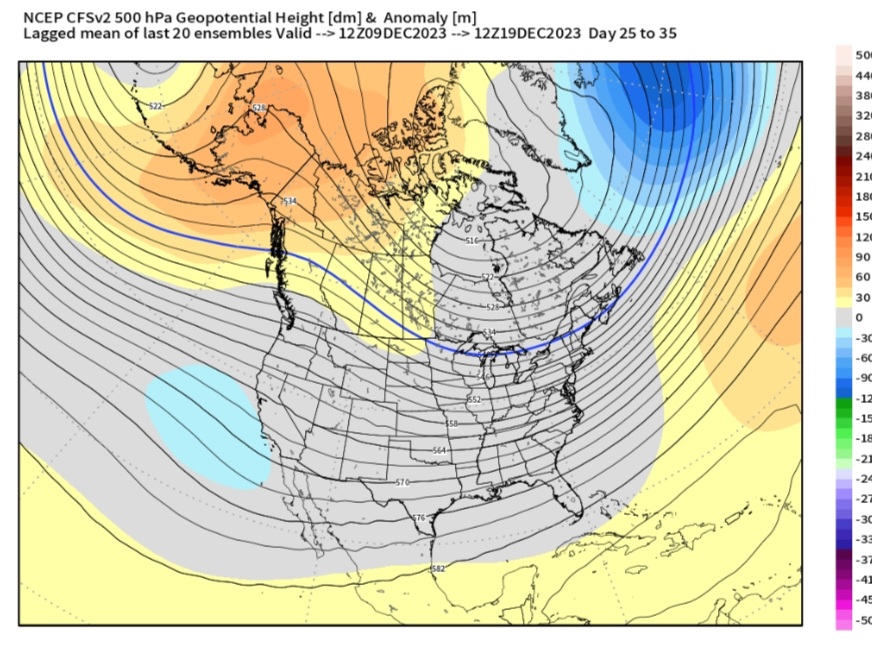
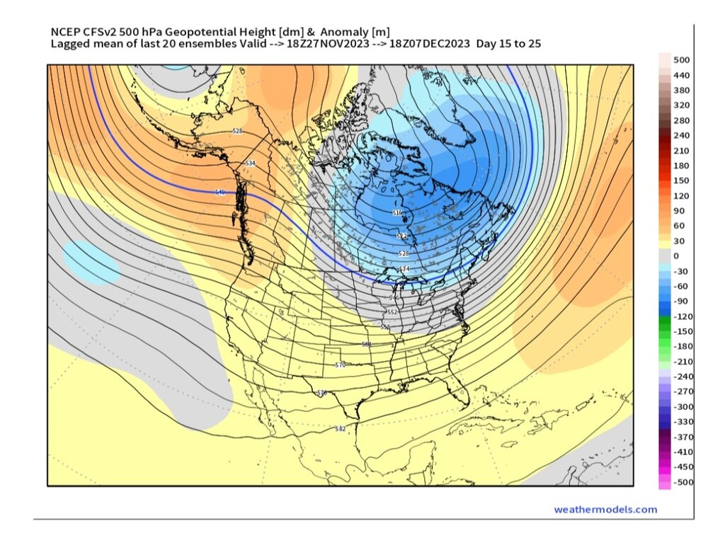
It's amazing how much the CFS Weeklies have changed for DEC in the last 2 days. Dates are on top of images:
-
7
-
 3
3
-
-
-
4 minutes ago, 40/70 Benchmark said:
Eh...to a point. However, the PDO can either constructively or deconstructivity interfere with ENSO when they are not in sync. Its part of the overarching system that is keeping this event in check.
Could be a perfect marriage if you think about it.
-
2
-
-
1 hour ago, bluewave said:
The Euro and the JMA completely missed the last El Niño forecast issued in November 2018. Plus your analogs are different from what the JMA is showing.
First, I said my analIogs have less +PNA, & -EPO.
Second, you're saying because they missed 2018-19 then it follows they automatically do the same? Caution...yes. But...inevitably miss the same way? Possible but not a given.
-
1
-
-
4 minutes ago, bluewave said:
Why do you take these 3 month runs seriously when the EPS can hardly get the pattern correct beyond 6-10 days? Same for all the other models. Remember the Euro forecast for the Nino 3.4 issued in September of +2.0 and we verified closer to +1.66. The one common denominator to all these winter model forecasts since 15-16 has been a cold bias in the East. I pointed out 18-19 since it that was the last time we had an El Niño pattern being forecast.
Yea, but you can't just say that when you don't like what its showing. No one should take a seasonal model as gospel but common themes & trends should be noted. The signal may be muted but can't totally ignore.
-
36 minutes ago, bluewave said:
But it did the same thing with the 18-19 winter forecast issued in November 18. It missed the La Niña or -PDO influence and just went with a cold Modoki pattern for DJF.
18-19 forecast

Verification

What are the odds CanSips, Euro, & JMA all terribly miss the entire seasonal forecast in NOV? It's not the gospel but not too terribly far off what my analogs are showing.
JAN


FEB


These analogs do have less -EPO.
-
2
-
-
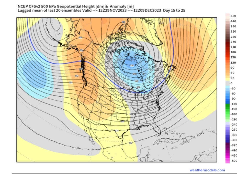
1 hour ago, stadiumwave said:
JMA... I'm not where I can post it but I'll put the link and you'll can pull it up. January February is like absolutely cold. DEC Is strong Nino was Dec
https://ds.data.jma.go.jp/tcc/tcc/products/model/map/4mE/map1/pztmap.php
DJF
DEC
JAN
FEB
That's impressive!
-
2
-
2
-
-
JMA... I'm not where I can post it but I'll put the link and you'll can pull it up. January February is like absolutely cold. DEC Is strong Nino was Dec
https://ds.data.jma.go.jp/tcc/tcc/products/model/map/4mE/map1/pztmap.php
-
1
-
2
-
-
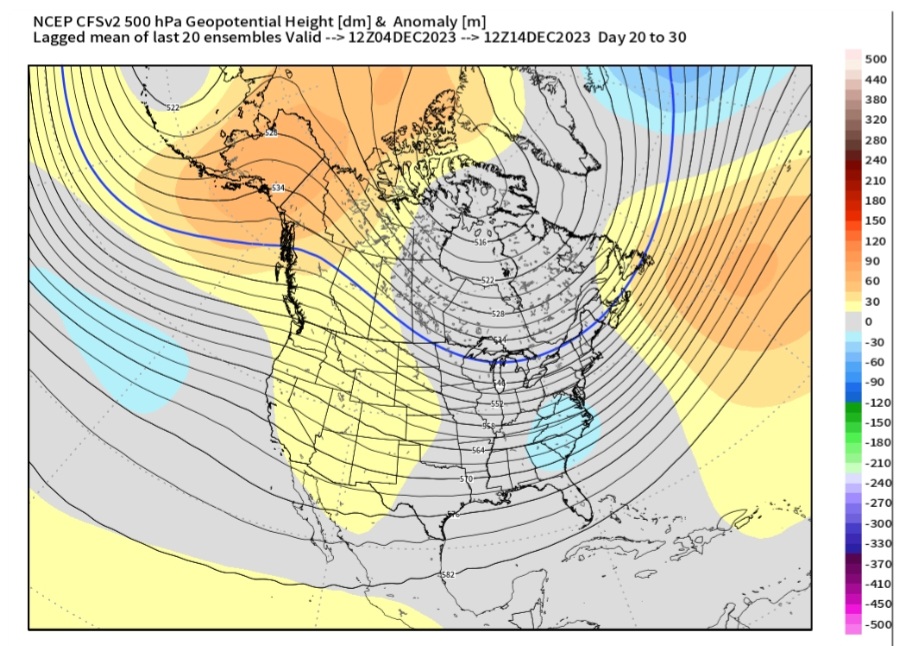
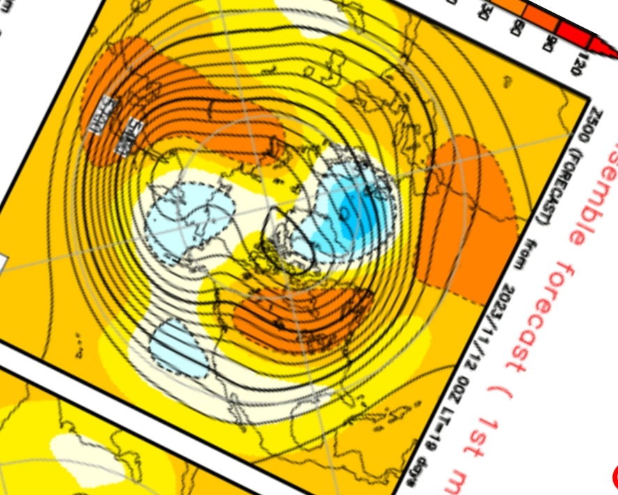
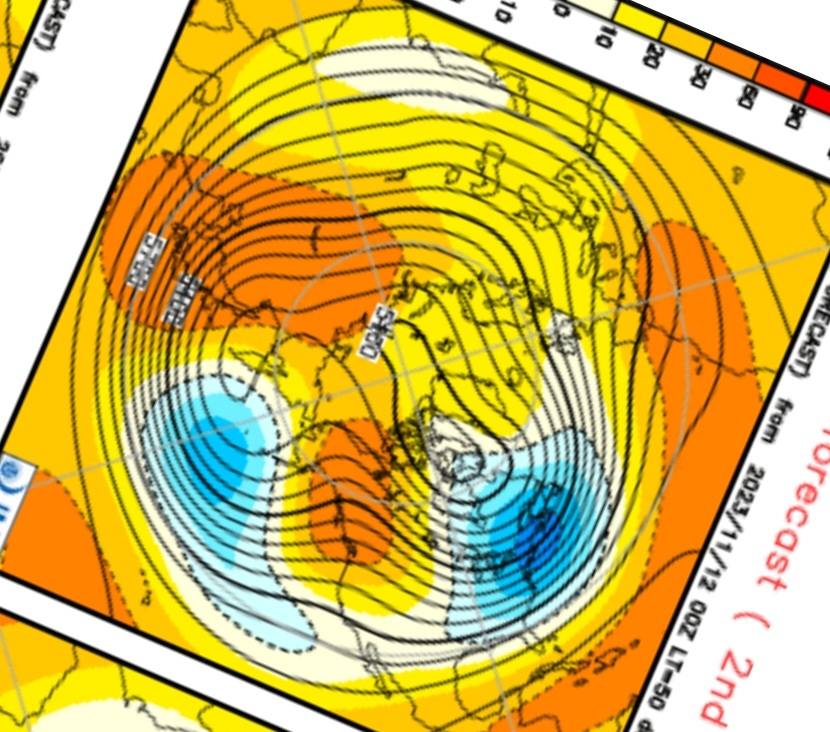
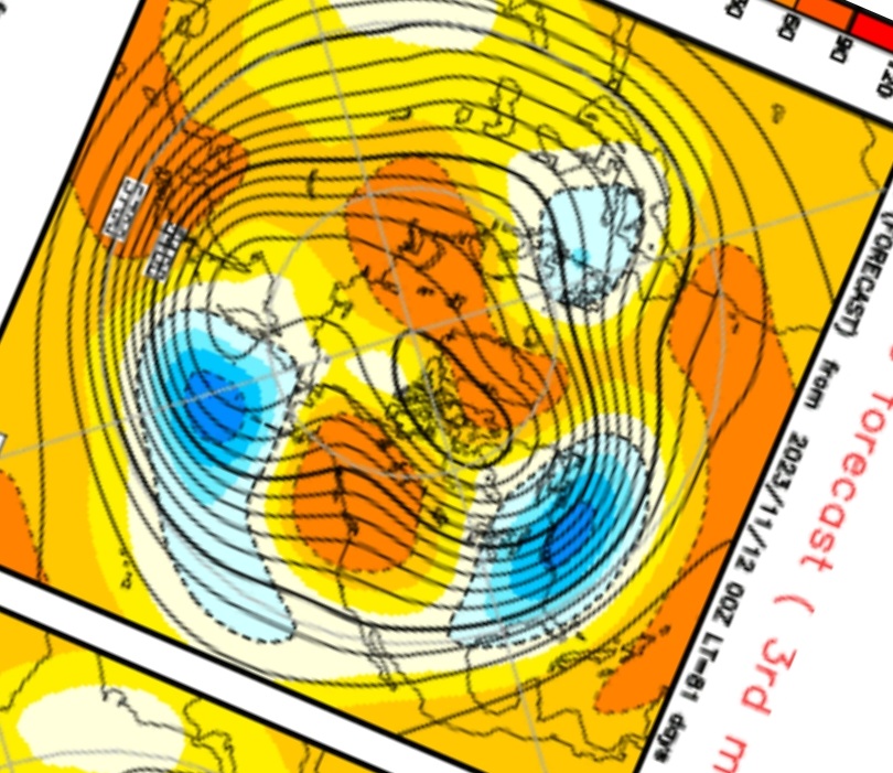
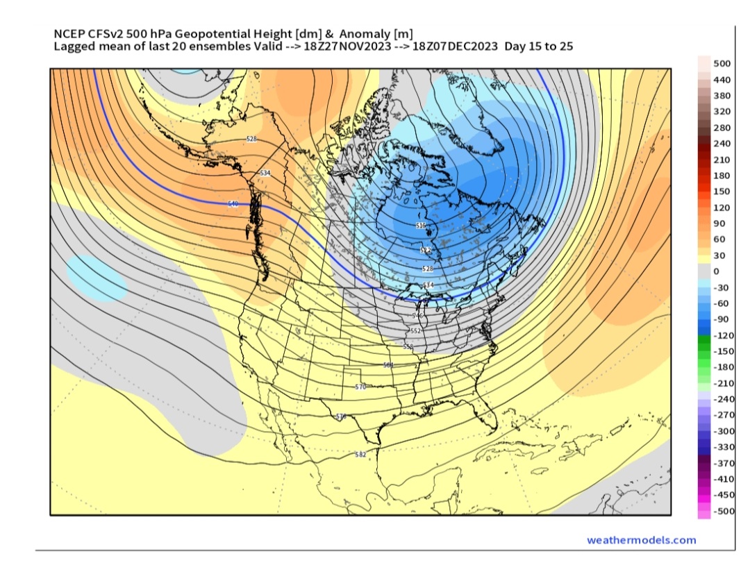
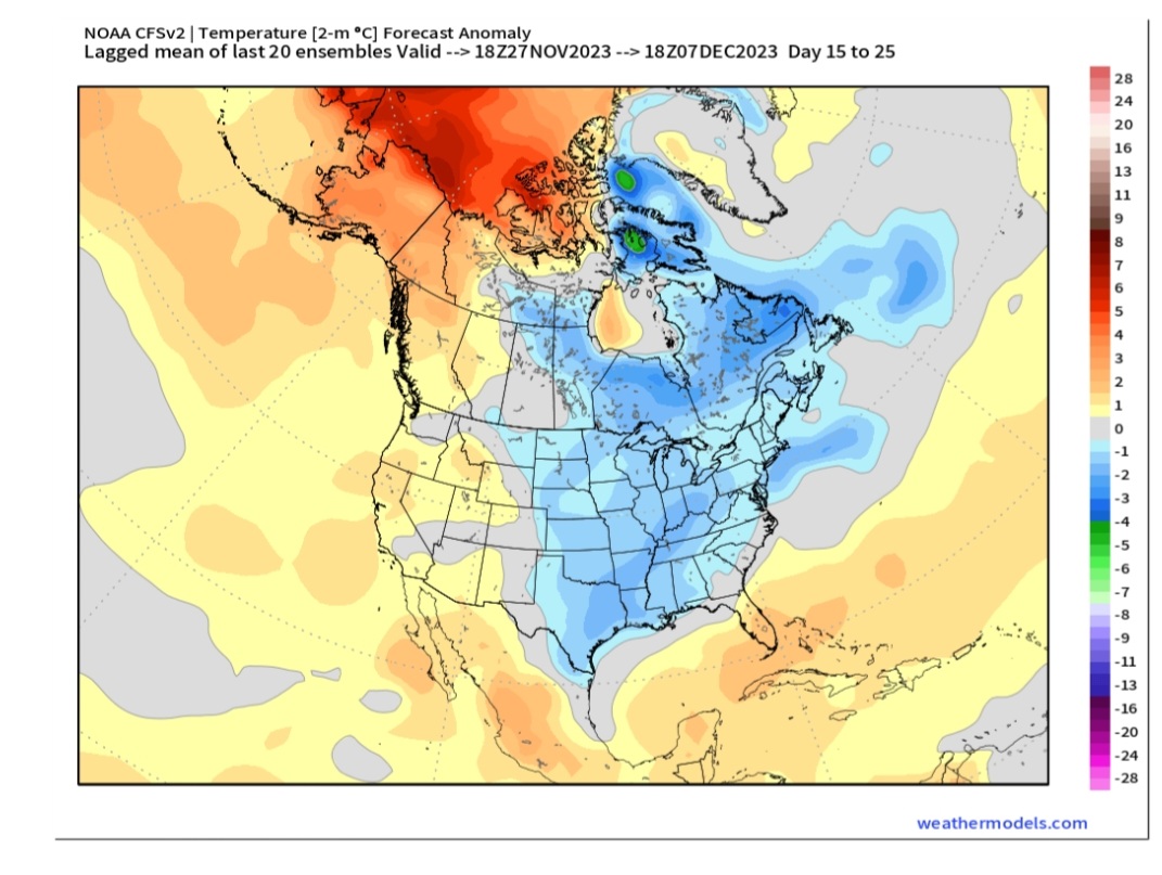
CFS Weeklies sure changed for the first week of DEC

-
7
-
-
So most models have MJO in either phase 8 or 1 to start DEC. It's not a very high amplitude but is this truly MJO? I know that the RMM does not always reflect reality.
-
3
-
-
18 minutes ago, michsnowfreak said:
Thanks. I noticed this on weatherbell. I also noticed that the extended usually leans warm whether or not it ends up being warm. For instance, the end of october/early November looked warm when it was four weeks out and ended up being cold as it got closer.
They've been awful!
-
1
-
-
-
1 hour ago, griteater said:
In other news, Nino 3.4 is down to +1.62 from a high of +1.81 on Oct 30
But that next Kelvin Wave, like those strong westerlies, will bump it up to 2.5. Oh wait, the westerlies didn't bump it up.
I feel like for 6 weeks, it's always that next big thing....and this Nino will show its monstrosity....except it never does.
-
3
-
-
-
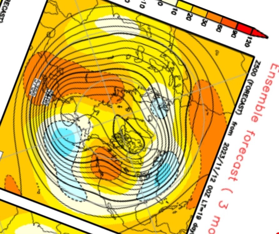
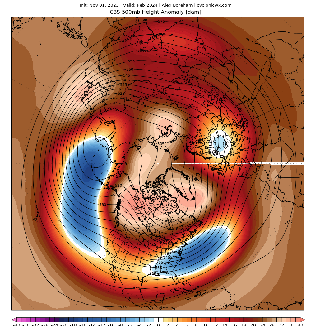
25 minutes ago, griteater said:
February currently looking like dynamite in a powder keg on a lot of the modeling. Here it is on the Copernicus Ensemble Mean
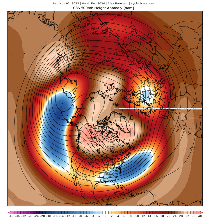
Can you post January?
-
12 minutes ago, GaWx said:
Fwiw, the Euro Weeklies are warm in the E US through at least 12/25/23 and with no sign of an impending change fwiw.
Correct. Which would not be surprising. However, the weeklies have been pretty much worthless past day 10 for a while. So while we probably should have the expectation of warm I do not think the weeklies have a hold of the pattern
-
3
-
-
4 hours ago, snowman19 said:
IMO 3.4 going super is inevitable at this point. Big subsurface push. The sea level anomaly and warm water volume are rising very fast and expanding now with the DWKW/WWBs and they have been ever since 10/30. We are on the verge of substantial strengthening/warming at the surface. This one is comingIt's only really super when it can sustain it on the ONI...3 mthn. Ain't happening.
-
1
-
-


El Nino 2023-2024
in Weather Forecasting and Discussion
Posted
JAMSTEC Updated. Remember,no 500mb maps. Looks warm & dry