

stadiumwave
-
Posts
1,168 -
Joined
-
Last visited
Content Type
Profiles
Blogs
Forums
American Weather
Media Demo
Store
Gallery
Posts posted by stadiumwave
-
-
4 hours ago, LibertyBell said:
That decade was excessively weird, so many el ninos in the 80s, you'd think they'd be snowier, but noooo.
80-81, 83-84, 84-85, 87-88 were big snow years in the extreme lower OV.
-
 1
1
-
-
On 12/27/2023 at 7:26 PM, raindancewx said:
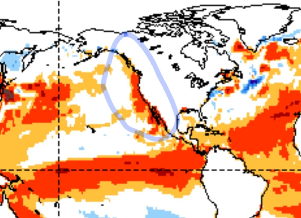
Tropical Tidbits has waters by Peru running below average now. Some cooling building West. If you remember March 2023, you had a period of rapid subsurface warming. This December is largely opposite. March was severely cold in the West and very stormy. Been warm and fairly quiet this month.
Early December, when the rising heat content was rising before reversing was certainly cooler for most than the more recent days. For what it's worth, the heat content should continue to rapidly thin...and sure enough the CFS has another +15 type month for areas in the Northern Plains in January at the moment.

CFS making its final moves for JAN prediction in its monthlies:
Pulled the warm anomaly bubble a little NW.

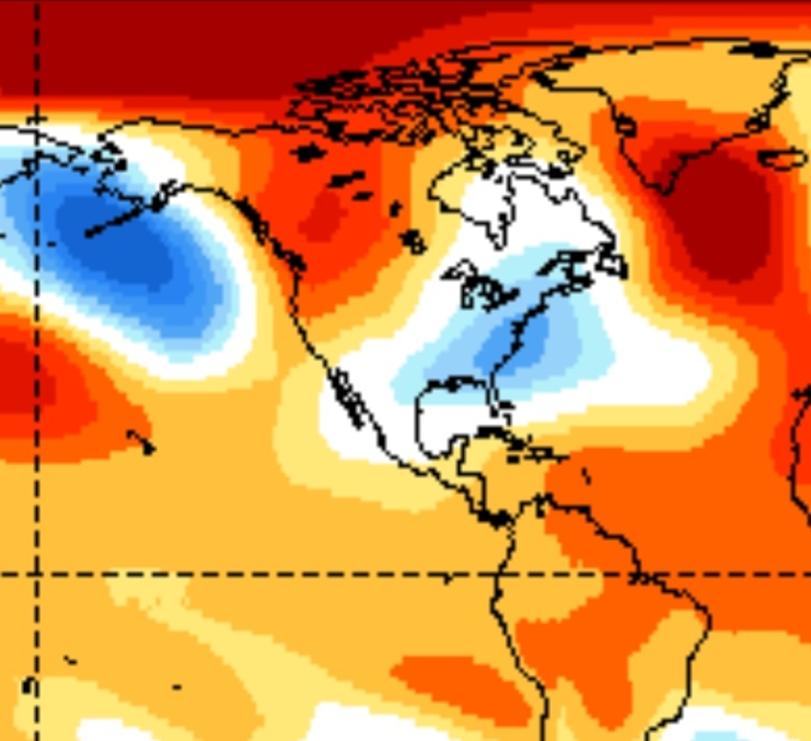
Thought this was interesting:
-
2
-
-
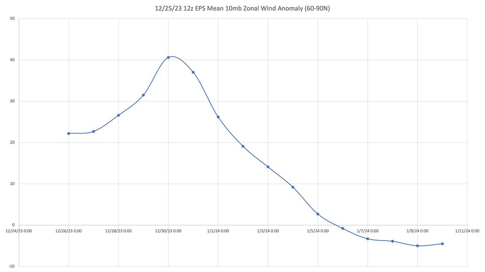
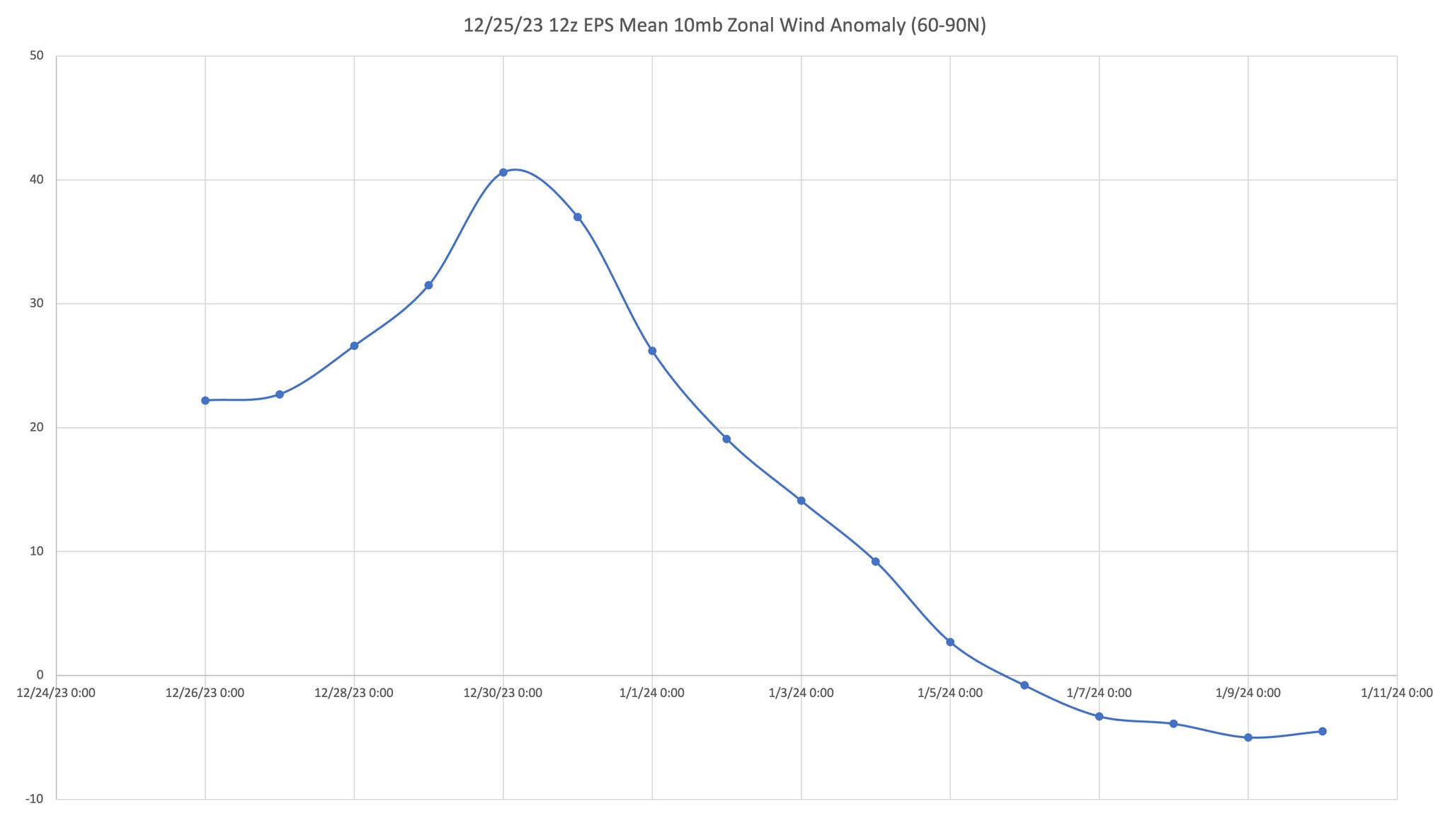
I know there seemed to be some concern models have been a little temperate with SPV forecast yesterday & today...but 0z GFS shows an SPV in serious trouble:

-
27 minutes ago, roardog said:
I'm not sure it's going to quite make the super tri monthly but it won't be too far off. Good job staying with your prediction even when things weren't looking great. Super Nina and extreme -PDO next year?
")
It'll be interesting to see for sure.
-
18 minutes ago, michsnowfreak said:
Did I say it was incorrect? This article was just a climate change piece based on a warm December weather pattern. Other than listing the Christmas temperatures there really wasn't data in it. I just thought it amusing that after the 3rd snowiest winter on record...and 7 years since Minneapolis has even had a below avg snow season...that alarm bells are ringing because of a snowless Christmas and warm December in minneapolis lol. It would be especially funny if they end up with another above avg snow season in the end.
That San Diego lady though. Lmao. Who spends $900 on a winter coat? It's too bad that she hasn't worn it. The 8° that minneapolis had in November must have reminded her of San Diego winters of yore. But props to her for running 5 miles in a tshirt on Christmas day when it rained all day in minneapolis. Hope her shirt wasn't white!
#opportunist
Same with Arctic Sea Ice.
-
1
-
-
Simon just tweeted some differences between the 51 member medium range & 101 member extended range:
-
36 minutes ago, 40/70 Benchmark said:
Important thing is that the PV is weak....I'm just hoping for a SSW for verification purposes. Its by no means necessarily winter cancel if the PV isn't absolutely decimated.
Correct! Which we've been saying since early DEC.
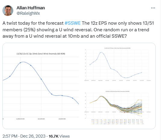
I'm anxious to see what the EPS 101 member ensemble says. It just seems bizarre that almost 80% of members would have a u-wind reversal to 13% 36 hrs later.
-
13 minutes ago, GaWx said:
Per Alan’s same source, the % on the EPS fell a little more from the 25% (13) he showed per yesterday’s 12Z to only 20% (10) on today’s 0Z. We’ll be able to compare this with the Euro Weeklies output this afternoon to make sure they agree:GEFS, GEPS seem to be backing off as well. They all have an event just not as strong as previously.
Simon Lee says the SPV has been knocked around since NOV & that even if this is not a "knock out punch" it will probably still get the job done as farcas sensible weather, or at least that's how I took it.
BTW, it's a good thread.
-
2
-
-
-
2 hours ago, stadiumwave said:
Simon seems unbothered by 12z
Personally, I know he's doubling down but I do believe you've got to take it all in. I have a hunch MJO forecasts are impacting stratosphere forecasts.
-
1
-
-
2 hours ago, griteater said:
Hopefully just a blip, but the 12z EPS had less SSW members this run.
Simon seems unbothered by 12z
-
40 minutes ago, brooklynwx99 said:
@GaWx is going to like the new Weeklies. wow
Can you post? I only have access to Mon & Thurs updates.
-
10 minutes ago, griteater said:
Hopefully just a blip, but the 12z EPS had less SSW members this run.
Can't say for sure because I don't have GEFS members, but just looking at the mean I'm guessing it had some members back off as well. Maybe you have access?
-
Surprised no one posted this tweet
-
2
-
-
If a split occurs, starting on JAN 7 per 12z GFS & warmong across artcitic continuing through end of run....then a great chance of a good period of winter in a lot of CONUS (esp eastern 2/3) is a good probability in the future. Can't guarantee the correct storm track for anyone, but the cold at some point would be a given.
Sorry for the giant run-on sentence, lol. My wife, who is an English teacher, would scold me, ha!

EDIT: Let me add that I do NOT think models have a good handle yet on whether the SSW results in split, & if so what kind of split, & how long does warming last. Models may handle that aspect poorly until 5-7 days before.
-
4
-
 1
1
-
-
8 hours ago, griteater said:
12z EPS Mean from Allan Huffman
-
6
-
1
-
-
12z GFS

-
4
-
-
GEFS has a split

-
7
-
-
2 minutes ago, GaWx said:
This 0Z 12/24 GFS is almost definitely a major SSW (we'll find out by afternoon) and is the first run I can recall with an actual split of the SPV.
Several ensembles & the control have split for the last 3-4 runs. This is the first GFS operational run that I recall splitting.
-
1
-
-
0z GFS

-
2
-
-
Click & read entire thread.
-
4
-
-
16 hours ago, snowman19 said:
The SOI nosedived today. -30. Huge drops like this during Ninos typically precede rather dramatic warming spikesJust simply means a big winter storm is likely as well in 3 weeks. Smart money on JAN 9-13 timeframe....supported by BSR as well.
-
2
-
-
-
1 hour ago, snowman19 said:
We are in a never ending loop, relentless. The WPAC is ridiculously warm for a strong/super El Niño and now we are losing the +IOD. So the forcing progression into January leads to thisEric shares Roundys composite. Roundys 100 day low pass constructed analog for the same date:
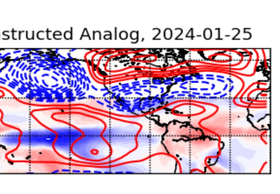


El Nino 2023-2024
in Weather Forecasting and Discussion
Posted