

stadiumwave
-
Posts
1,168 -
Joined
-
Last visited
Content Type
Profiles
Blogs
Forums
American Weather
Media Demo
Store
Gallery
Posts posted by stadiumwave
-
-
-
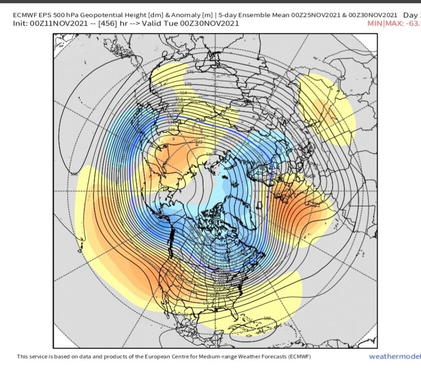
To demonstrate what a worthless waste of time it is to post weeklies past 15 days:
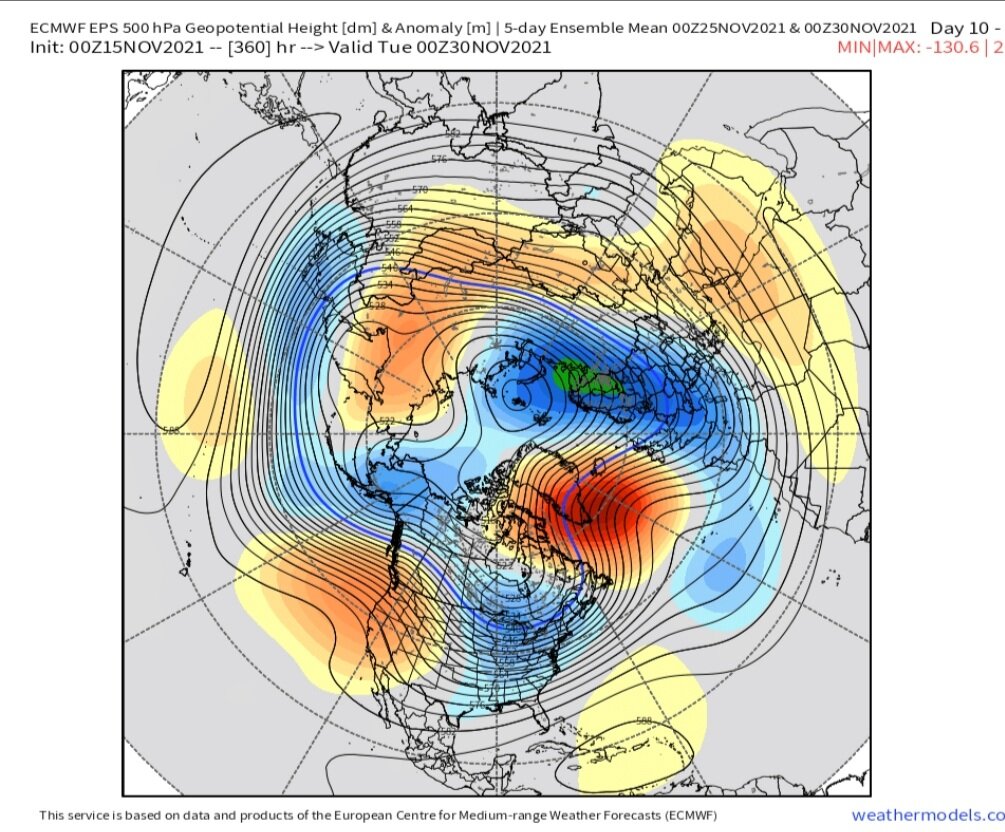
New NOV 30

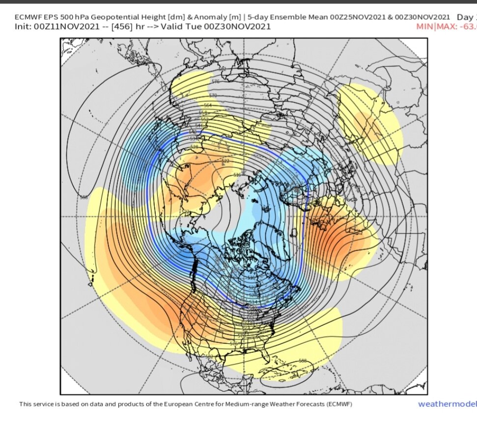
Old NOV 30
-
 3
3
-
-
15 hours ago, snowman19 said:
The metric by which all ENSO events are measured by are the actual SSTs, which are about to drop in the next few weeks and in a big way. It’s peaking, yes and it’s done in the subsurface. However, declaring it “dead” as JB did is asinine. Dead Nina’s don’t continue to have SST drops. When the surface starts warming, then it’s dead
Well JB is JB...lol. I don't follow much. Uses too much hyperbolic language for me which will drive a literal person insane.
The remnants of its life (coldest subsurface waters) is surfacing & the supply is empty after that.
-
On 11/13/2021 at 6:46 PM, 40/70 Benchmark said:
But it's also becoming east based...in which case strengthening helps the winter cause.
Very much so
-
1
-
-
On 11/13/2021 at 5:02 PM, snowman19 said:
@stadiumwave @MJO812 It’s doing anything but dying, in fact, it’s about to undergo a huge period of strengthening by early December :
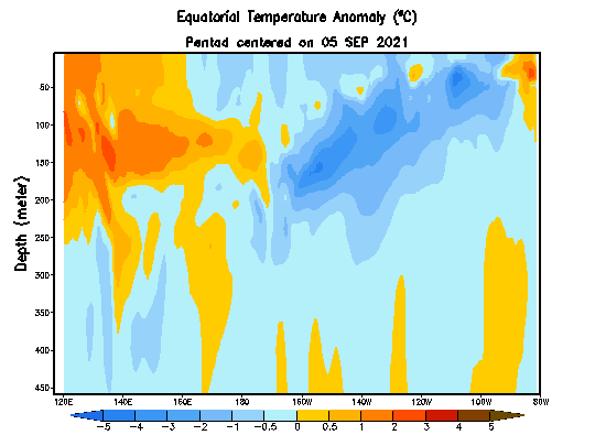
The coldest waters down in subsurface are in the process of surfacing but yes the Nina is dying. After the coolest waters surface in region 3 we will warm after that. Both are correct.
Just look at the subsurface progression. Subsurface is warming. Coolest waters are moving to surface. Then...its over. Anyone looking at that Subsurface progression & thinking this Nina is getting stronger is smoking crack....bad....and in total denial.
.gif.c9f55c4d1a3c10a657235fa19800535c.gif)
-
1
-
-
Guys, this Nina is dying fast per latest sub-surface:

-
3
-
-
This La Nina is dying. Who would've thought a month ago?
Lol @ CFS strong Nina forecast
-
2
-
-
1 hour ago, MJO812 said:
Interesting tweet

Yea it is interesting. I did the winters a year after minimum, since that is where we're at, since 1950:

-
1
-
-
2 hours ago, Ginx snewx said:
Dog shit in Dec
Weak signal though. Anything outside 10 days is really low skill anyway.
-
I'm starting to lean away to fast start to winter. After a good 3-4th week of NOV expect a less favorable pattern. PV will strengthen until MJO wakes up. If it wakes up PV will take hits again mid-DEC leading to weakening, disruption, possibly a full blown SSW.
JAN into 1st half of FEB may be the best potential before ridging takes over after that.
-
On 10/23/2021 at 9:19 PM, Daniel Boone said:
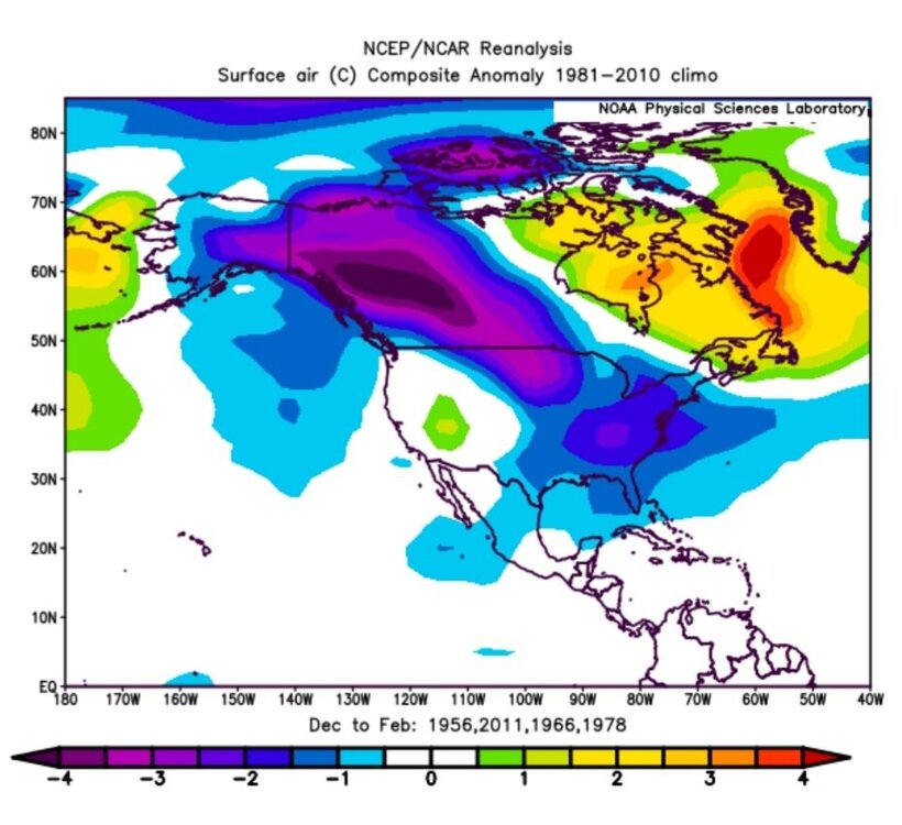
Yeah. I know that. Over 40 years experience. As mentioned earlier, and take a look at those years. Blocking is key in those colder la nina /-PDO Winters, ala; 2010-11.
Sorry, did not read any other post. Just chimed in & saw your post.
-
1
-
-
Euro Weeklies...if it verifies close then likey. Like...good through DEC 10
-
On 10/15/2021 at 7:29 PM, Daniel Boone said:
Good post as usual John...the thing that concerns me however is even if the La nina stays weak is the -PDO.
See if u can come up with. Composites of that criteria.
I know the 1960's featured that combo as well as all other enso combos as well and they were all pretty much cold/ snowy. Blocking was formidable that Decade.
Most La Ninas have a -PDO average for DJF. Don't forget that 2010-11 was -PDO & cold.
Bottom line:
+PDO winters do not automatically = Cold winter
-PDO winters do not automatically = Warm winter
It's more complex than that.
-
3
-
-
54 minutes ago, ORH_wxman said:
Yeah, I mean, if you have a -3 SD block in the Davis Strait, then that will definitely overwhelm typical Nina SE ridge climo for sure.
Right. BTW, was not saying this winter is going to be 2010-11. There are several years that serve as analogs for NPAC SST's in OCT: 1950, 1955, 1964, 1970, 1971, 2005, 2007, 2011, 2013. It's just amazing how different all those winters were...some polar opposites.
BTW, 2007 is probably #1 match, but probably means zippo at this point.
I'm just not a fan of typical climo, cookie-cutter predictions. It's not really yhat simple, which you of all I know...knows this.
-
28 minutes ago, ORH_wxman said:
At least this year actually looks like a La Nina over the Pacific rather than just a thin strip of below normal SSTAs in the ENSO region....look at the difference between last year and this year I posted further above. Huge difference despite the La Nina actually being a little weaker this year....but in practice, it will probably act stronger and more typical than last year's did. That would be my guess anyway based off the look.
That still doesn't tell us whether we'll get a lot of snow of course....you can have classic La Nina look still produce a total blowtorch ala 1999-2000 or 2011-2012 if a vortex sets up over AK/Bering Strait, but the other features will still be present like -PNA and SE ridge, etc, etc.
Of course, but then there's this:

So many factors can make a massive difference.
-
27 minutes ago, 40/70 Benchmark said:
Yea, buy the November change...just a matter of how deeply into the month it takes. Won't be immediate because we need to build a cold supply.
Later the better.
-
2
-
-
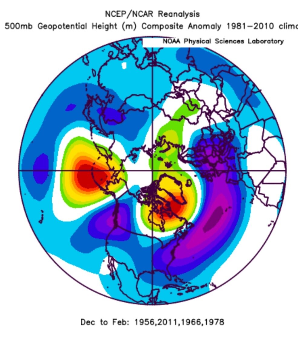
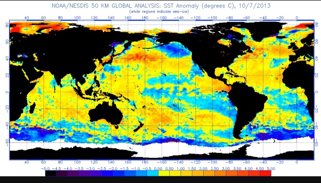
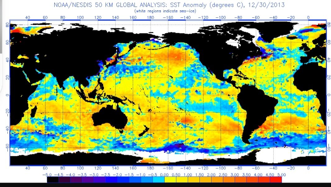
On 10/4/2021 at 1:54 PM, StormfanaticInd said:
PDO region has really cooled over the past several weeks. **Could** prove to be a negative for this winter.
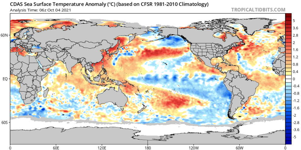
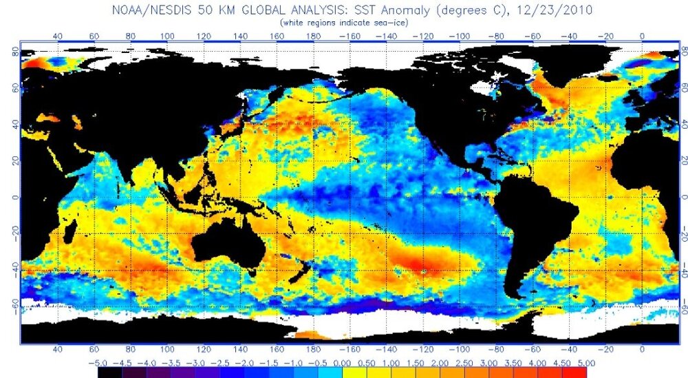
I would not focus too much on NPAC SST's in early OCT. Rosby Wave trains in OCT/NOV often lead to great fluctuations in NPAC sst anomalies. Example...OCT 7, 2013:

BTW, very close match to now. So is 2010. So is 2011. All of those years have wildly different winter outcomes. Here is NPAC SST by DEC 30, 2013:
Point is early OCT NPAC SST's probably give no clue to winter. If NPAC looks like that mid-DEC then different story. It could go any number of ways right now.
-
4
-
-
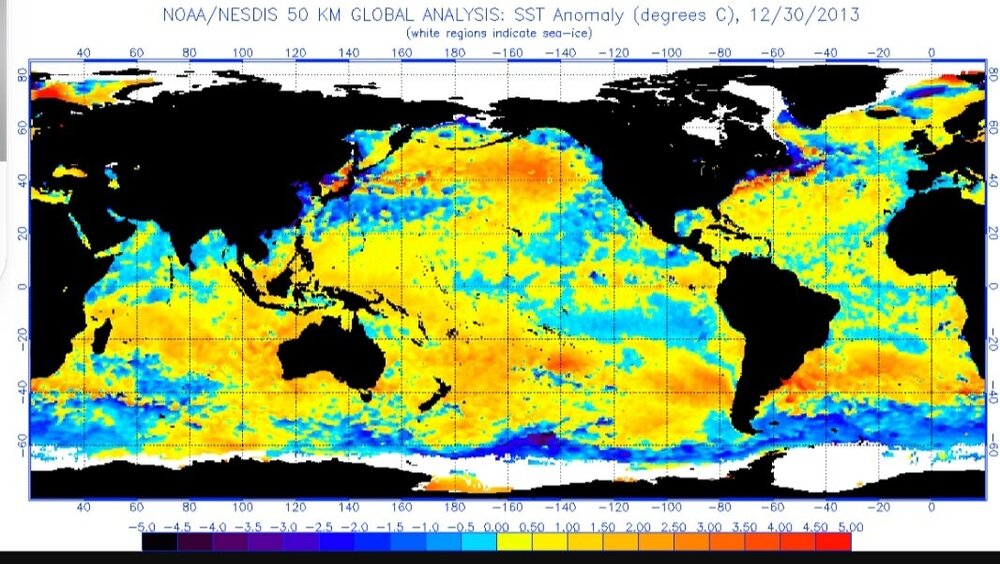
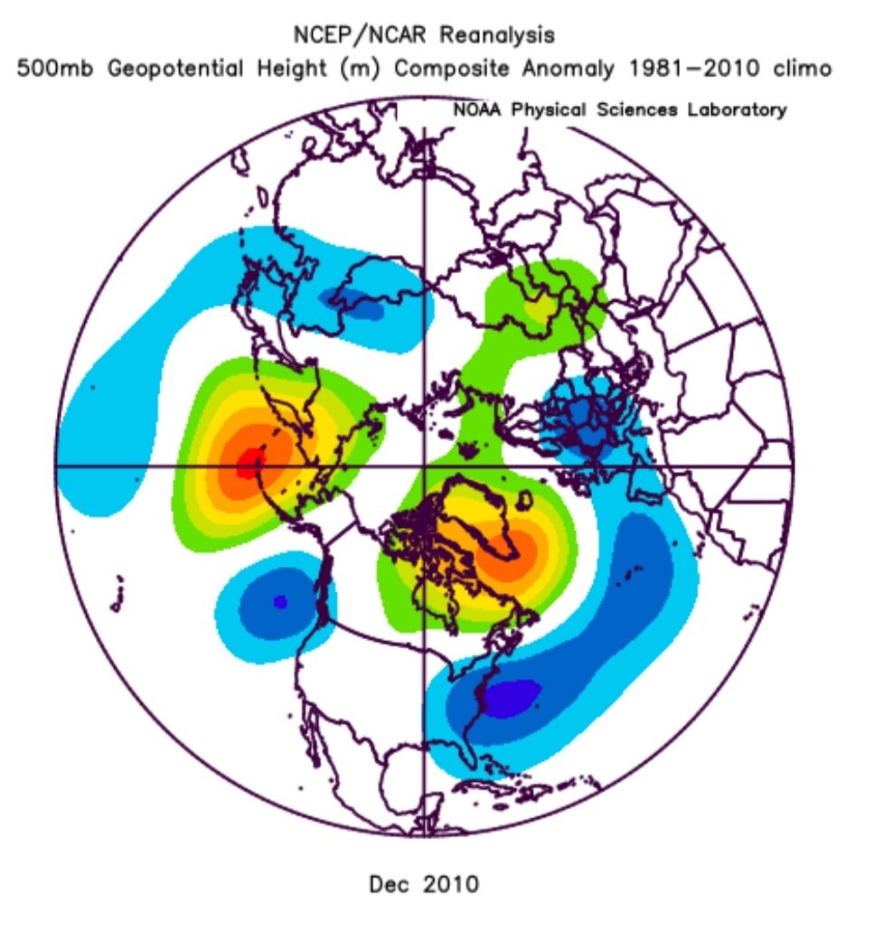
For everyone wanting to make a big deal about NPAC SST's in OCT like every year. Remember NPAC SST's are subject to large fluctuations in OCT/NOV.
I give you SST's for October 7, 2013:

October 7, 2021...CURRENT:

Rosby wave activity in OCT/NOV leading to large fluctuations in NPAC SST's in short time periods, should prevent conclusions about winter using NPAC SST's at this point
-
1
-
-
3 hours ago, ORH_wxman said:
I’d like to see the H5 look on those. None of these are all that accurate from this time range but the 2m temp forecasts are even less accurate than the upper air stuff.
Scooter and I still make fun of those seasonal models in autumn 2014 that (correctly) predicted a monster EPO ridge over AK but had like +2 temps from the northern plains to NE.

How does the model even reconcile that?
Unfortunately NMME page does not have 500mb.
-
19 minutes ago, 40/70 Benchmark said:
Those are not good changes in the aggregate...looks more RNA and +EPO
It's guidance. I wouldn't get too worked up yet at every detail. I would make note of a very strong cold source advertised. Keep on mind these models actually are decent only on a monthly forecast at the beginning of the month being predicted. If you've been following just about every model has not been doing well on the 2nd month out.
But for sure the teleconnections stink on that update. CFS took a step in a good direction but has a longway to go for a good winter pattern.
-
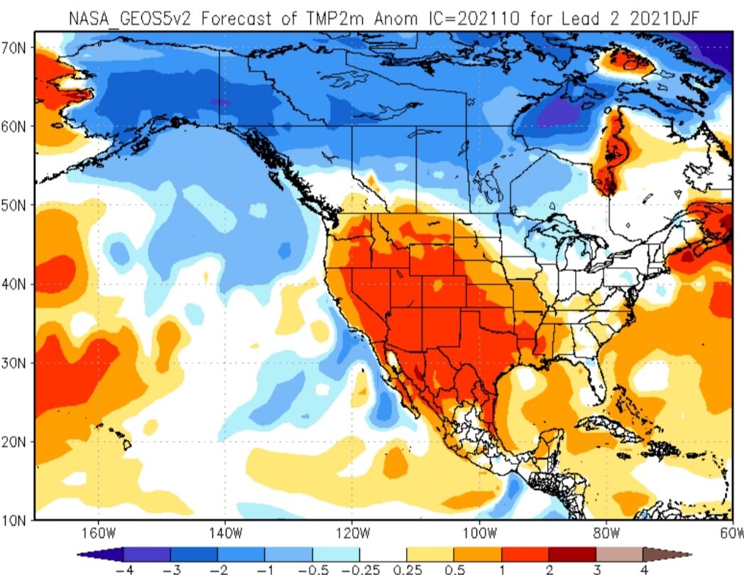
NMME Page...updated. Little change most notable is colder over western Canada.
NMME Older

NMME New

CFS Older

CFS New

Canadian Older

Canadian New

NCAR Older

NCAR New

NASA Older

NASA New

-
Euro Seasonal Update....ugly
NEW DEC

OLD DEC

NEW JAN

OLD JAN

NEW FEB

OLD FEB

Certainly it's not gospel but I do not like the trend. Hopefully NOV improves.
-
9 hours ago, 40/70 Benchmark said:
96-97 was cool neutral FWIW..
How about 75-76, 89-90 and 2011-2012?
Throw those in & OCT is not as currently forecasted. My blend is not a forecast. I'm simply showing which analogs come up with the best OCT forecasted match. I then simply shared what that blend would look like for winter. Ironically the blend is all 2nd year -ENSO.
It's interesting & is info for others to take into account when putting together a winter outlook. Just another slice of the pie.
-
1
-
-
An interesting blend:
1996-97, 2000-01, 2008-09, 2017-18...all 2nd year Nina's:
OCTOBER

That's very similar to what is forecasted by latest CANSIPS:

That blend has a great first half of winter:
DEC/JAN


Then ridging takes over in FEB:
FEB


Pretty intriguing with the October if that forecast verifies.
-
1
-


My Winter Outlook 2020-21
in Weather Forecasting and Discussion
Posted
Is @Isotherm OK? I haven't seen one post from him on any forum.