PivotPoint
-
Posts
714 -
Joined
-
Last visited
Content Type
Profiles
Blogs
Forums
American Weather
Media Demo
Store
Gallery
Everything posted by PivotPoint
-
I like the trend on the GEFS Ive been waiting to see some similarities between gfs/euro/eps as they all have been pretty conflicting past 7-10 days. Finally think the pattern change is a foot. The mean ridge out west is showing some stability and the pac fire hose is finally getting blunted. Might take some time to get the lower level temps to cooperate and recover from the pac onslaught but I think we’re starting to see the light at the end of the tunnel. As bob said, NS is tougher on models at med-long leads. Just keep the southern stream adding fuel to the fire and something will catch... eventually
-
That look is not bad... not bad at all
-
December/January Medium/Long Range Discussion
PivotPoint replied to WinterWxLuvr's topic in Mid Atlantic
I love when people say “cherry picking” when discussing weather modeling. There is in fact no such thing. The term cherry picking can only be use in the sense of the phrase when discussing outliers and their realative distribution away from a mean. So, in weather modeling every single model run is A) independent from all other runs, B))intrinsically lacks continuity i.e. Lorenz’s Chaos Theory. So there is no such thing as cherry picking model runs. For our snow chances, model runs typical sequence could go: Good, bad, bad, good, good, bad, good, bad, bad, get the point. In the previous data set which one would you tell another that they cherry picked — the good or bad run? Anyways, all that aside I liked showmethesnow’s analysis above. However, I just can’t take anything at face value when talking about PV and NAO domain features beyond 3-5 days. I think it’s a fruitless exercise. The predicatablity and verification of ensembles to accurately predict those features at that range is basically as good as guessing one number out of a hundred, right. Low odds. I look at it more simplistically. What I like is something I mention a couple weeks back when I saw the trough get dumped into the western states and stay put for a time being. Eventually, with enough reload of heights being ramped in AK and that trough axis swinging east, something timed (or better with NAO help) would provide us with some opportunities. But I put no stock in foguring out the NAO domain beyond 3-5 days. Never seems to play out unless it is a stable and dominant feature. Then there’s some accuracy predicting beyond that. -
^ Wow. Unbelievable. Really Congrats. Remember this cause we sure will
-
I mentioned this point a couple days ago and I agree. The northern confluence was well modeled. In conjunction with a well defined southern sw it’s actually a good combo for long/med lead model accuracy. To me, this is a case of the players on the field being “head over heels” better than the others player. Hence, making it easier for the models give us a predictable and REPEATABLE output. All an opinion (of course) but observation wise, is the way I see it.
-
Those words are synonymous brother lol
-
You can use both. Obviously change in snow depth is more conservative but you can use snowfall to measure accumulation too
-
You’re right it is. Just searching for any trend. But yea a litt close in
-
I’m not even gonna say it seriously though, EPS is soon right??
-
That’s not as much as I was expecting but good to see nonetheless come on king euro
-
Holy bump on the ukmet If the cmc wins the day with a score for dc I’ll be enternally grateful. Albeit over done a couple days ago it has consistently said at least something for dc (minus 2-3 runs?) Ancecdotal I think a north shift is a typical trend we see with the juicy stj sw. Also I felt since 5 days ago that the confluence being molded was probably at the very least “slightly” over done. Hopefully my pure guess was right
-
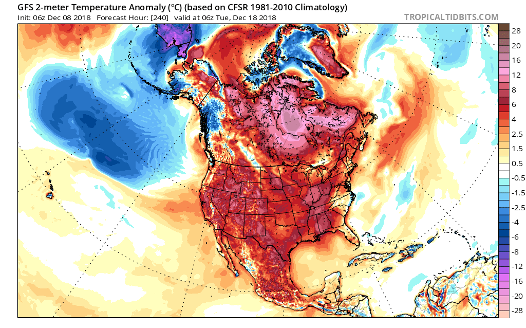
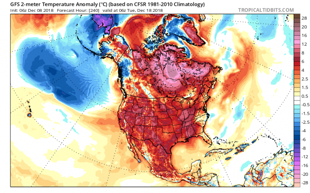
Oh, yea I 100% cherry picked that to demonstrate the lack of 2m cold on this side of the globe. Good analysis on your part.The one factor I see working in our favor is when you roll that image through time you see riding start to build back over Alaska and cold dumping to the west coast. We know in those scenarios it’s just a matter of time before that cold slides east and with even mild blocking in the NAO domain you can get east coast action. What I don’t like is the mjo forecasted to go into warm phases for east coast then crash into the cod. But it give me an active southern jet and marginal cold air, and to your point, we can score in late December with that look.
-
Lack of cold air in the 10 day isn’t exactly what you’d call confidence building for our snow chances
-
Yea, I agree too. I find it pretty interesting too that the GFS (and most globals) in general seem to do better in the mid/long range when the northern features (strong NAO, AO, etc) are on one side of the bell curve or the other. It makes sense: the more stable the input the more repeatable the output. But what’s interesting is the northern component to the consistency. In this case, my opinion is the only mechanisms of increase for northward movement would be driven by a)not currently modeled relaxation in confluence, b) well timed piece of energy embedded in northern flow exiting at a favorable moment which could lift the barolocnic zone between the approaching SW and NS (which in essence is a relaxation in confluence), c)not currently modeled amplification of the SW which of course, has a cap to how much it can deepen. I give dc metro a 20% chance of dusting-1” which would be pretty sweet!
-
I’m actually fairly impressed with the GFS for this storm. Going back over it’s past six runs it’s been pretty consistent while others have caught on last 3-4. although euro has been consistently south too for most part since two days ago. someone correct me if I’m wrong but I don’t see the NS features changing much each run so I’m thinking only way dc metro scores anything is the SW has to amplify quickly and broaden its precicp shield. Which is a tall order with all that confluence
-
lol. thats pretty good It was payback for "storm mode" suppressing the storm
-
Its amazing how close this is to our ideal spot. Just a couple tweaks

-
My point was favoritism. My apologies for not making that more clear. And none of what I was expressing was intended to be taken as an argument -- more as an observation. An argument would assume I have an underlying belief that I can change a viewpoint or outcome -- which I do not believe is the case here. Not sure where you are seeing the contradiction but here's a clarification: Paragraph 1 is an observation of favoritism and an anecdotal recount of how I've seen posts handled over the years Paragraph 2 are my personal feelings towards posting in general and why all posts I think should be left in place even if sometimes they are slight banter. Because who wants to read post after post after post of technical weather stuff without a shred of humor or symbolism to break the monotony, sheesh. I don't think it's a shame and I appreciate the explanation of how you personally handle the process. My main point was favoritism leads to obvious problems when its used in conjunction with post censorship. I appreciate you saying this. I think that all makes sense and is fair. I just don't think censorship is too strong a word. It is censorship when you take a post and completely delete it -- again, presuming it wasn't offensive or violent. Moving posts to a different thread makes sense and I can do a better job of posting in the right place myself. But if the post is deleted (which Ive seen happen to mine, and were not offensive in the slightest), that is censorship... don't know what else to call it. You have a better word I'm open to hear it.
-
Lets call a spade a spade here: There are certain posters who are allowed to have banter comments in non-banter threads and consequently NOT have their posts disappear. These posters include red-taggers, friends of moderators, moderators themselves, and those who have tenure on the board. There are PLENTY of banter comments during storm mode in storm mode threads I've read over the years. The decision process (if you can call it a process) behind the posts that get deleted and the ones that don't falls solely under the jurisdiction of the moderators (the few). I, myself, enjoy the complexity and individuality of any poster's unique styles and preferences when posting in any thread. I understand the need to stay on-topic and have relevant and accurate information dissemented to the board and therefore agree with the purpose/concept of moderating. However, restricting and limiting a certain poster's "voice" while purposefully NOT restricting others because you favor them, is in my opinion, a form of censorship. As long as the posts are not morally offensive or intended to belittle or degrade any group or individual, I say let the post stand. Agree or disagree, thats fine. That's the point of free speech by the many, unedited by the few.
-
This post did not get moved to banter. I wrote it in banter. Well done to you sir! An observant one you truly are. Thank you for your comments
-
Lol @ storm mode yesterday... Someone should of been the voice of reason
-
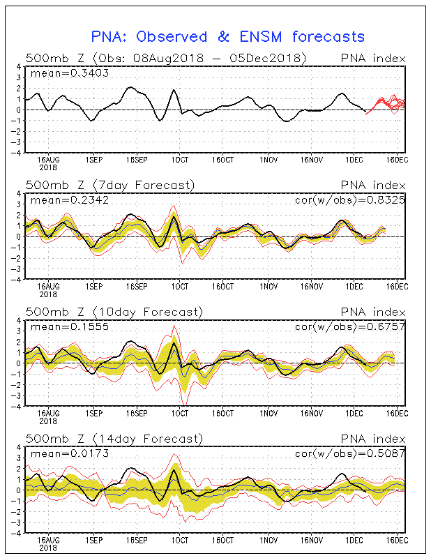
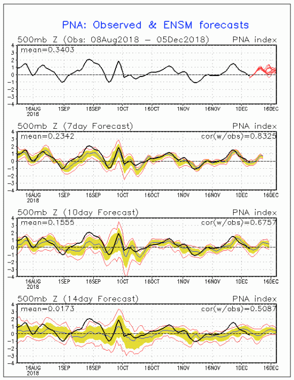
I posted last night (in discobs thread, oops) about the 12/21-12/26 period. I see potential for building heights around Greenland and a +pna that albeit isn’t strongly depicted for this window, does show up in positive territory on latest gfs telleconnection.
-
This time period the week before christmas keeps peaking my interest and has been showing potential signs of -nao and pretty decent +pna... Euro weeklies have advertised this period as a possible window with “potential” blocking in the favored areas
-
I’ve been reading/posting for about 5 years. IMO this thread has stayed pretty on-topic wouldnt day I’ve seen a whole lot of “insane” posts. But to each their own I guess. On topic: the one big feature I’ll be watching (trend wise) next 48-72 hours is the ridge axis out west. It was touched on this morning and I definitely agree that our more successful outcomes tend to happen when the heights are ramped up and the line centers through Idaho. Key feature imo
-
True. The trend has been that area. Need that famed northern trend to start Thursday/Friday. We got time