CAPE
-
Posts
36,851 -
Joined
-
Last visited
Content Type
Profiles
Blogs
Forums
American Weather
Media Demo
Store
Gallery
Everything posted by CAPE
-
16 for a low here. Snow melt will begin in earnest today with a high of 40. It's been nice having snow otg with little melting for 3 days.
-
Maybe some freezing fog tonight.
-
21 here currently after a high of 34. Tomorrow will be the first day of significant melting.
-

Late January and February Medium/Long Range Discussion
CAPE replied to WinterWxLuvr's topic in Mid Atlantic
Thoughts from Mount Holly for late week- Thursday-Friday... A cold front to our northwest will gradually move into the region during this time as a wave of low pressure tracks along it. Ahead of the front, a much milder air mass will move in as heights continue to rise and surface winds remain southerly. Many areas will make in into the 50s on Thursday, or else well into the 50s. Gradual rain development from northwest to southeast is expected as the front slowly approaches, although much of the day should remain dry south and east of I-95. We then watch the evolution of the front. Model agreement has worsened regarding the evolution of this system, with the GFS today lurching to a much colder solution than previous runs and showing a significant snow and ice event for at least the northern half of the region. This would happen if the cold front moves through faster and the wave of low pressure tracks over or south of us. However, other models like the EC and GEM remain warmer with mainly rain save for the very far north as the low tracks just north of us. This would bring another round of temperatures in the upper 40s and 50s on Friday. While I am not all in on the GFS solution, it is concerning. With a very strong Arctic high to the north of this frontal system, and lingering snowpack over our region, the setup is ripe for models to display a warm bias. Would not be surprised to see a colder, less amplified trend on this system in the coming days. Would be doubtful of winter weather impacts extending any further south than the GFS indicates, and as it is the GFS is probably pushing it. However, it does appear that winter weather risks are increasing at least across northern portions of the area. Friday night... Friday night will see the departure of the frontal system. As the cold front moves away, Arctic air will rush into the region. The mild conditions of Thursday and Friday will be replaced by readings in the 10s and 20s. The overall evolution of the system and whether it looks more like the GFS camp or EC camp will determine how precipitation ends. Am always skeptical of short duration back-end snow, but it does look like the rain/ice/snow line will collapse towards the coast late in the event, especially if the colder model solutions are right. And the further north you go, the better the chances for a lengthier period of frozen precip near the end of the system. Either way, with the temperatures likely to be crashing before precipitation ends, the setup looks quite favorable for a rapid freeze-up on Friday night, so we will be keeping an eye on this.- 4,130 replies
-
- 4
-

-

-
- prime climo
- cold canada
- (and 1 more)
-
Late January and February Medium/Long Range Discussion
CAPE replied to WinterWxLuvr's topic in Mid Atlantic
Why does this kind of remind me of the St Patty's Day storm of 2014? Seems somewhat similar, and we stole that one. It was way north with the frozen then kept coming south until it was ours.- 4,130 replies
-
- 6
-
-
- prime climo
- cold canada
- (and 1 more)
-
Late January and February Medium/Long Range Discussion
CAPE replied to WinterWxLuvr's topic in Mid Atlantic
Maybe it will trend back to what it had 5-6 runs ago, when it looked good and the GFS sucked. Now the GFS looks more like the Euro did, and vice-versa. They really need to get their shit together.- 4,130 replies
-
- 3
-

-
-
- prime climo
- cold canada
- (and 1 more)
-
Late January and February Medium/Long Range Discussion
CAPE replied to WinterWxLuvr's topic in Mid Atlantic
I think this is what we need. A second wave to keep the precip going behind the front. Otherwise it mostly occurs in the warm sector then the cold comes in. -
Late January and February Medium/Long Range Discussion
CAPE replied to WinterWxLuvr's topic in Mid Atlantic
With the 6 hour panels and no p-type maps, this is what can be gleaned- A handful of members have a coating of snow for parts of the region, thus the overall mean is 0.1 -0.2" for that period. Up your way looking at surface and 850 temps, and the 6 hour precip panels, it is conceivable (per this run) you could see a few hours of freezing/frozen. Probably too much analysis for a mean at this range and given the brief period of opportunity as depicted. Big picture is it looks like the precip is exiting as the colder air comes in.- 4,130 replies
-
- 2
-
-
- prime climo
- cold canada
- (and 1 more)
-
Late January and February Medium/Long Range Discussion
CAPE replied to WinterWxLuvr's topic in Mid Atlantic
Cold chasing rain on the 6z EPS. -
Late January and February Medium/Long Range Discussion
CAPE replied to WinterWxLuvr's topic in Mid Atlantic
That is a strong push of cold on the back end of the wave as advertised. Problem is there isn't much precip left at that time(looking at the GEFS)and what tends to happen, as we well know, is the cold/dry air pushes in and there isn't much lift behind the front. Not to say that there wont be a brief period of sleet/snow at the end, but it looks as though we would need a bit of a second wave along the front to get anything significant. eta- 6z GEFS does suggest several hours of freezing/frozen for some of the area. Trend. -
Late January and February Medium/Long Range Discussion
CAPE replied to WinterWxLuvr's topic in Mid Atlantic
I never said February was warm specifically. The winter as a whole was above average. December was a torch and January was saved by the cold period leading up to the big storm. It quickly warmed up again after that. Yes you are right, Feb was generally average temp wise here(one of the few places on earth). If you recall that was one of the warmest months ever recorded globally, and I would have to go back and look at h5 and 850t, but I would bet there was very little cold air available in our source region. -
Late January and February Medium/Long Range Discussion
CAPE replied to WinterWxLuvr's topic in Mid Atlantic
The GEFS has consistently had something for the Feb 6-7 timeframe but confined to the SE then offshore. That's the period I thought had some potential based on the advertised h5 look a few days ago. Still a window to watch.- 4,130 replies
-
- 1
-
-
- prime climo
- cold canada
- (and 1 more)
-
Late January and February Medium/Long Range Discussion
CAPE replied to WinterWxLuvr's topic in Mid Atlantic
You can cross that off the list lol. Been pretty darn cold overall this month, with well above avg snow for eastern areas. Low to mid 20s during the day multiple times and single digit lows. Also, I am starting to like Ninas here lately. Only winters that have produced avg or above avg snow have been Ninas since 2016- and that winter was a Big torchy Nino save for 10 days and (for many) one big snow event with some fluky blocking. Ninas aren't always awful in this region.- 4,130 replies
-
- 1
-
-
- prime climo
- cold canada
- (and 1 more)
-
Rooting for Stafford. Niners are tough and gritty, so it won't likely be easy.
-
Awful. They deserve the mediocrity that is coming.
-
I actually screamed like the Ravens were playing, to cheer for a division rival lol. Just so tired of KC and Mahomes already.
-
Awesome. Congrats to the Bengals. Exciting young team. What an effort to come back in that building against that team.
-
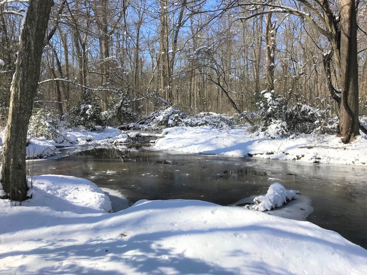
What a day for a hike. Nothing like having Arctic cold air in place for multiple days after a snowstorm. Can really get a chance to be out in it and enjoy before it goes to melty slush. A couple photos I took earlier today from Tuckahoe.
- 96 replies
-
- 10
-
-
Late January and February Medium/Long Range Discussion
CAPE replied to WinterWxLuvr's topic in Mid Atlantic
Well, it is hard to argue that is the outcome more times than not in these setups, but there is a chance. Euro getting it done at this juncture. The GFS 'dominance' over the Euro thing is mostly hyperbole btw. GFS blew chunks this last storm.- 4,130 replies
-
- 2
-
-
- prime climo
- cold canada
- (and 1 more)
-
Late January and February Medium/Long Range Discussion
CAPE replied to WinterWxLuvr's topic in Mid Atlantic
I have not really paid much attention to the late week deal, but just looking at the 0z runs of the ops/ensembles, the Euro/EPS, and to some degree the Canadian, have weaker low pressure along the Gulf coast and move it NE along the cold front such that the low tracks to our SE. The weaker nature of the low allows the cold to press east faster on the Euro. Canadian/CMC ens don't get the cold in quite as fast so its mostly rain. GFS has a stronger low tracking along the front further west and delays the arrival of colder air. GEFS mostly agrees but there are a a handful of members that imply some frozen. As usual, we watch the trends in the coming days.- 4,130 replies
-
- 5
-
-
- prime climo
- cold canada
- (and 1 more)
-
From Mount Holly AFD this AM The dominant feature through this period will be the surface high building towards and over our region, resulting in tranquil conditions for the region through this period. As mentioned by the previous shift, low level flow is expected to become northeasterly as early as Monday night, continuing through Wednesday in response to not only the surface high shifting east, but also the weak low that is expected to develop off the Carolina coast and lifting further northeast (well off shore) before stalling). The net result of all of this is potential for patchy fog/freezing fog both Monday night and Tuesday night. Dew point depressions should be very low, especially in areas where the snow pack remains through this period (which will likely be mostly over the coastal plains). Two factors that could limit fog/freezing fog development are winds, especially Tuesday night could be in the 5 to 10 mph range, and if any marine layer stratus propagates in before the fog develops. All that being said, there was enough of a chance to warrant including a mention of patchy fog/freezing fog in areas with a 3 deg F or less dew point depression both nights. For Monday night, this would be primarily the coastal plains, but the potential exists across the region Tuesday night.
-
3 degrees at 7am
-
Late January and February Medium/Long Range Discussion
CAPE replied to WinterWxLuvr's topic in Mid Atlantic
5.8" Sadly not what the GFS was advertising lol. -
Late January and February Medium/Long Range Discussion
CAPE replied to WinterWxLuvr's topic in Mid Atlantic
Y'all are due. You can have the goods on this one, as long as I get a few inches. On a heater here minus the MLK slop fest.- 4,130 replies
-
- 1
-
-
- prime climo
- cold canada
- (and 1 more)