

CAPE
-
Posts
36,757 -
Joined
-
Last visited
Content Type
Profiles
Blogs
Forums
American Weather
Media Demo
Store
Gallery
Everything posted by CAPE
-
Pretty much cleared up in the last hour here. Temp up to 58.
-
Is that a weenie rule?
-
12z EPS precip for the window of interest- Nothing is etched in stone ofc, but this is more useful as a forecast tool at this range than volatile op runs.
-
100% this. Hell with coveting draft picks at this juncture. Its NOW time. He is a proven top 5 pass rusher. Ravens weren't finding a guy like that in this weak ass draft class. If they get Lamar's deal done in the next few days, its game on signing Free Agents.
-
I'm not opposed to it. There are some things to like about the LW pattern on the ens means. I posted about it yesterday. Op run snow maps tho.. I know, its what the kids like. (and Will)
-
Those snow maps 10+ days out.. Gotta be.
-
Yeah I figured. NBD. Just odd. I'll post my grade here when Winter is actually over lol
-
Why is a poster from the NYC subforum here linking to their thread to grade the winter? Don't we usually do our own thread AFTER winter is completely over?
-
Word is Nnamdi Madubuike is back working out. Man if he is healthy and playing this coming season..
-
Lamar posted this yesterday lol
-
I was listening to a Ravens podcast yesterday and there was strong indication the Ravens were going to make a big move. Apparently they are very close to getting Lamar extended. Word was it would take 2 first round picks to get Crosby, and that the Ravens would probably not be willing to pay that price. Well. I guess they were.
-
A successful outcome for that window continues to look dependent on a -WPO, +PNA, and a southward displaced TPV. A pretty favorable combo, but the AO/NAO is not good, so timing would be critical.
-
Eh, not exactly the ideal look at h5 for a MA snowstorm. Surface isn't bad but if that HP ends up a bit further east it wouldn't end well. It's March though, and some weird shit can happen.
-
Plenty of time. Nice to see an iteration that depicts a possible shortwave along the boundary at this juncture. As is its close to something decent.
-
Something like the 12z euro did here-
-
Maybe here- And here- As @frd posted, the WPO is tanking, plus the Polar Vortex is on our side, as advertised. Need to time something and hope its not just cold chasing a storm that tracks to our NW. Intriguing at the very least.
-
Not sure it would be wasting money. It wont germinate until the soil warms up some- it will just be dormant for awhile.
-
Ninas are pretty much death to your area in winter, which is in the downslope area of the higher terrain the to west. Ninos should be better with big coastal storms that aren't late developing/offshore. Maybe this coming winter will be more fruitful. In summer that same effect causes it to be generally dry (with prevailing westerly winds) relative to surrounding areas. A veritable desert. Frustrating for a weather enthusiast unless dryness is preferred.
-
With a favorable Pacific and the TPV in that position, I think a moderate storm is possible. +NAO or not this isnt likely a 1993 type deal- which I wouldn't want anyway as it sucked here.
-
Boilerplate.
-
Potential around St Patty's day. Pretty good h5 look esp for mid March. A lot would have to break in our favor, but probably the next(last?) chance. As advertised, the Pacific is quite favorable. WPO ridge, lower heights around the Aleutians, and a +PNA. That in combination with a Southward displaced TPV can bring enough cold southward. Just need a wave to ride along the boundary.
-
12/5: 1.3" 12/14: 1.8" 12/31: 0.2" 1/1: 0.1" 1/18: 0.4" 1/25: 7" snow/sleet (plus 0.3" zr) 2/23: 10" 3/2: 1.1" T: 21.9"
-

Outta gas and Outta Time: Early March Winter Storm finale
CAPE replied to Ji's topic in Mid Atlantic
Obligatory pic. Didn't pay much attention and wasn't expecting much, but did notice some of the guidance this morning had a streak of 'heavier' precip through here. Wasn't even snowing when I left work in Easton. Nice little finale if this is indeed the end of winter. Just over an inch. Next- early summer in a few days.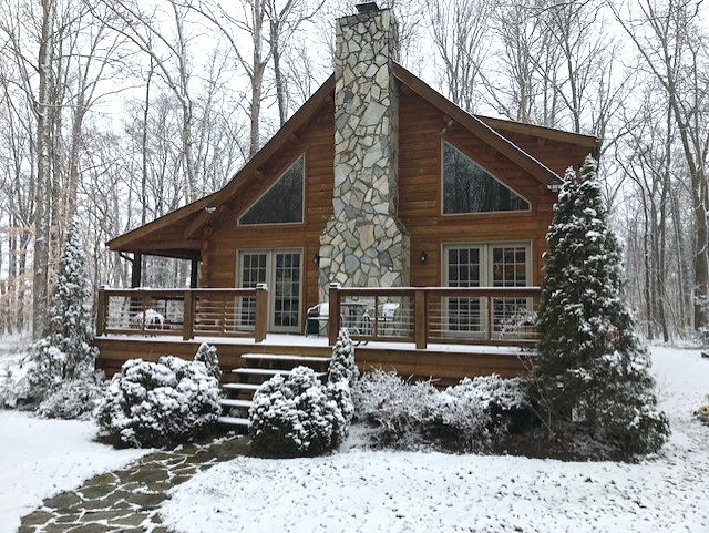
- 959 replies
-
- 12
-

-

-
Outta gas and Outta Time: Early March Winter Storm finale
CAPE replied to Ji's topic in Mid Atlantic
29 with a steady light snow falling. A solid inch on the deck. -
Outta gas and Outta Time: Early March Winter Storm finale
CAPE replied to Ji's topic in Mid Atlantic
My house is in that bright yellow band. Just looked at the cam and the ground is covered and snowing hard.
