

40/70 Benchmark
-
Posts
73,398 -
Joined
-
Last visited
Content Type
Profiles
Blogs
Forums
American Weather
Media Demo
Store
Gallery
Posts posted by 40/70 Benchmark
-
-
4 minutes ago, ORH_wxman said:
We take...

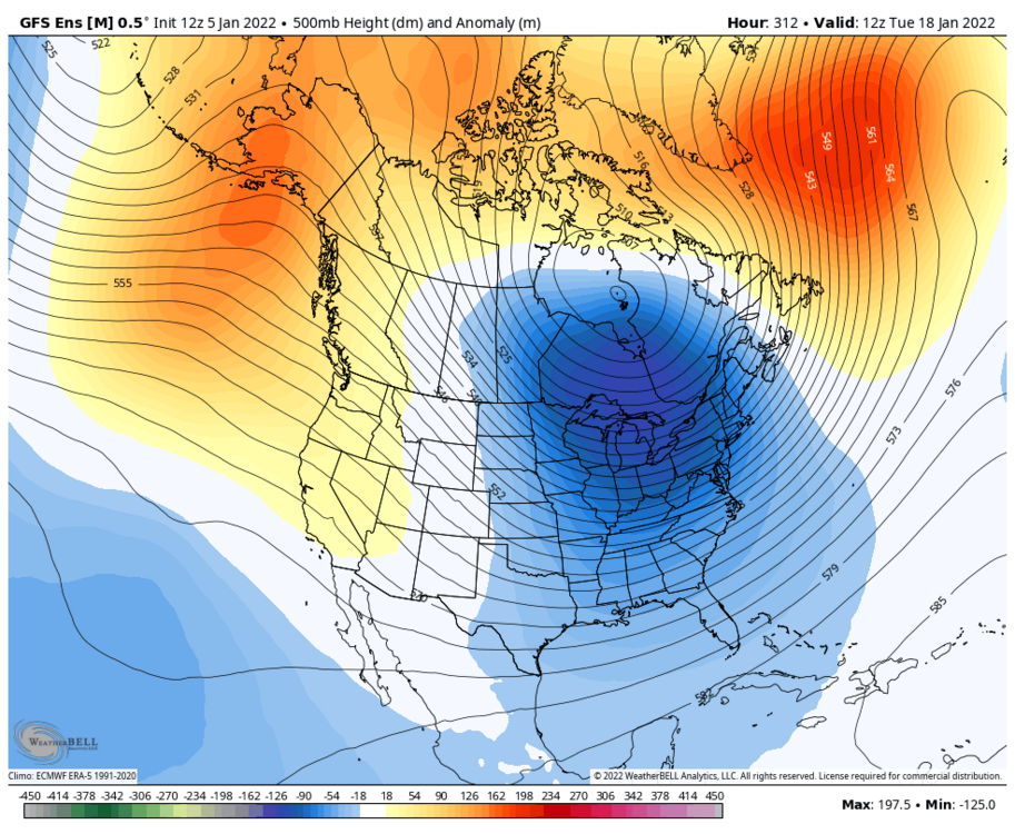
Looks like the PV lobe wants to play ball on the GEFS
-
6 minutes ago, eduggs said:
Midwest, PA, and NY - wow! Long time.
Some regression for Binghamton after that 50" event last December lol
-
6 minutes ago, The 4 Seasons said:
For science.

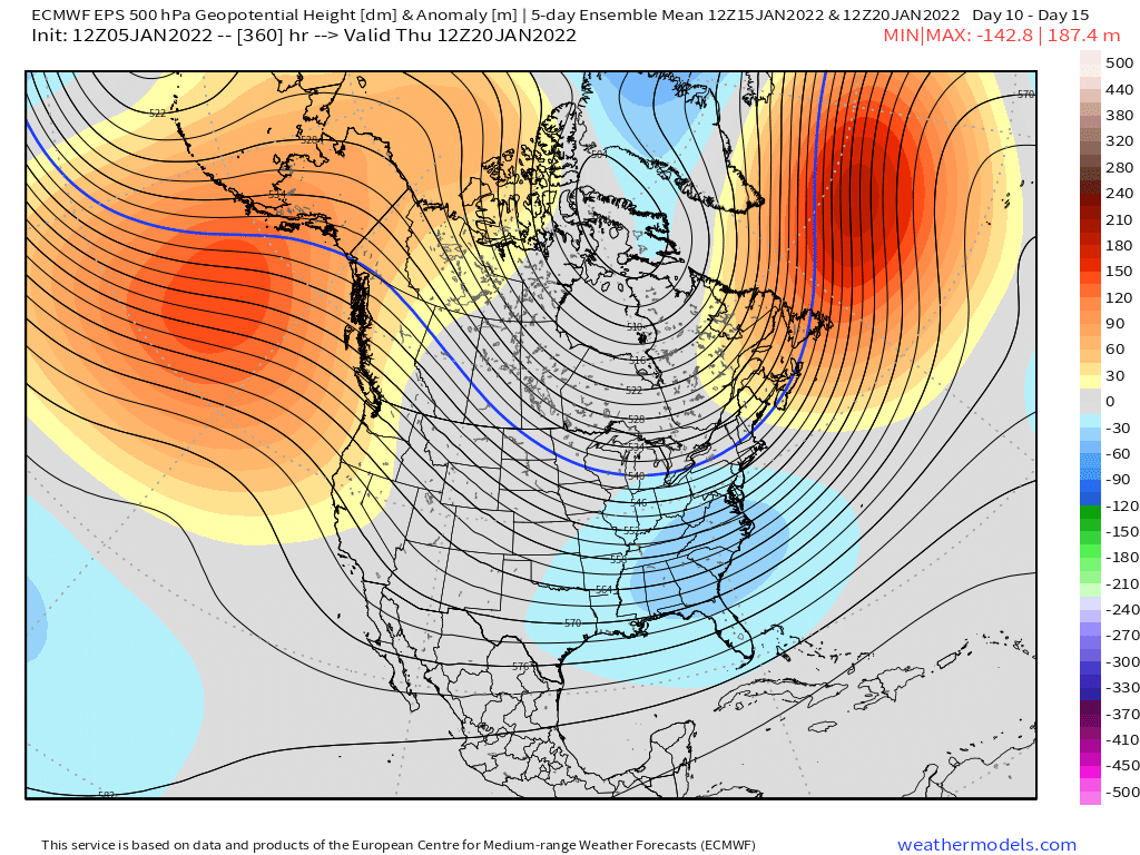
Funny how that map outlines the mean H5 pattern so far this season lol
-
 1
1
-
 1
1
-
-
1 hour ago, Sey-Mour Snow said:
What do you think about the one GEFS is showing for mid month? Head fake?
I'd be surprised if we popped another legit NAO in January.
-
26 minutes ago, ORH_wxman said:
Clown range Euro is cooking up a monster....clown range as it is, but ensembles have also been hinting at that mid-month period for something bigger.
That is for real...imagine if that PV lobe phased in.
Wow.
-
1
-
-
3 minutes ago, The 4 Seasons said:
Watches? Didn't see that one coming. Guess with the uncertainity and possibility of ramping up its covering the potential but 4-6 is really pushing it for a watch here. Thats 5" avg.
1 minute ago, 78Blizzard said:Yet their discussion said "an advisory level event is the most likely scenario."
Just covering their asses in case it ramps up a bit...what is there to lose?
-
2
-
-
11 minutes ago, eduggs said:
What happened to this subforum? When I lived in MA 20 years ago and subsequently posted in the predecessor forums, hobbyists actually knew how to read weather model output. People looked at soundings and upper level charts. There was a lot less wishcasting and snow-entitlement.
I guess somewhere along the line 3rd party snow maps and twitter meteorologists made us all stupid. It's kind of like how GPS ruined our sense of navigation.
I only look at that level of detail when:
1) I'm issuing a forecast.
2) Its a very interesting solution.
Neither applies today.
-
1 minute ago, ORH_wxman said:
This definitely looks like some midlevel goodies...most of us are obviously still rooting for the 0.75-1.00 QPF slamming on Atlantic inflow, but aside from that, it's probably going to be nice snow growth in the ML banding that is consistently being signaled over SNE. Even like a 13 or 14 to 1 ratio will give 4" on a quarter inch qpf...and it's possible ratios are a bit higher inside a decent band.
Yea. as disappointed as I am in the grand scheme of things, I don't expect this to underperform snow maps.
-
-
Just now, TauntonBlizzard2013 said:
Snow maps FTL… unless you get under a good band, that’s a pretty light snowfall
I don't think so...ratios should be decent.
-
Just now, ORH_wxman said:
Actually you posted 06z vs 12z....i was talking 00z vs 12z. 06z was definitely better than 12z.
Yea, sorry.
-
Just now, JC-CT said:
he said 0z
Yea, my bad.
-
1
-
-
Just now, TauntonBlizzard2013 said:
Euro is a general 1-3, 2-4….. mainly 1-2” for most
2-5".
-
1
-
-
Just now, wxsniss said:
Oh I understand, that was my concern as well, and why the 6z/12z meso runs today are reassuring.
12z Euro almost identical to 0z, a hair less than 6z.
It cut snowfall by about a third across the board.
-
2 minutes ago, bristolri_wx said:
Why? The modeling has improved since 00z, not the other way around. The trends have been better...
And then slipped back somewhat from 06z to 12z.
-
Snowfall is qualitatively similar in distribution to 06z, but its quantitatively a couple of inches less across the board.
-
5 minutes ago, wxsniss said:
Just missed you in the overnight shift, now tuning in for Euro... yeah I posted that the site going down last night was a mercy kill for all the overreacting over 1/5 0z NAM.
Haven't wavered from thoughts since weekend: 3-6/4-8 for eastern SNE as a start, and now that we've survived ingest of shortwave sampling in Pac NW, I still anticipate this could trend NW in final 48 hours with potential for higher totals.
The angst wasn't about the NAM as much as it was the SW getting sampled at the same time.
-
5 minutes ago, STILL N OF PIKE said:
Except when a back door is coming , right .
Or when the marine influence creeps in during a snowstorm.
-
Just now, ORH_wxman said:
The extreme magnitude of the RNA trough definitely mucked up some forecasts....even medium range forecasts, not just long range. Honestly, we had a legit good NAO block so even a slightly less deep RNA trough probably nets us a lot more cold and snow in December. But that's how the dice fall sometimes.
The change in the PAC is pretty fortunate timing since we have lost the NAO blocking for the time being....we're going to be living off the Pacific. Some of the guidance hints at -NAO trying to come back later in the month but I'm not biting on that yet. My guess is any big NAO block would likely wait until later in the winter to return.
I agree...I think the next big NAO is later Feb into March....but even just trend it more neutral for January. This is shaping up a lot like January 2011, though...obviously that doesn't have to mean 50" of snow, but you get the idea.
As far as December goes, I can live with missed forecasts when they are easily explained.
-
1
-
-
6 minutes ago, forkyfork said:
this could easily jump more nw tonight
I actually don't think you're a troll, but I think you do get kicks out of slamming home a take when it doesn't jive with the preference of the masses.
-
1
-
-
20 minutes ago, CoastalWx said:
Still think post 10th is good. Maybe the one thing I'll get right.

I went with 2010-2011 and 2020-2021 as my two primary ENSO analogs due to placement of max anomalies, but the mistake I made was not adhering more closely to 2010-2011 due to how well coupled this la nina is, as opposed to last year's no-show ordeal. I needed to incorporate strength more. Big oversight on my part in November...that would have alleviated the main flaw in my forecast, which was reversing the PNA from December to January. As far as the warm December goes, the record RNA was just so massive and that is extremely difficult to foresee. I'm happy with how I have handled the polar domain, though I think the lower AK heights also persisted a bit longer into December than I had envisioned, which further augmented the warmth that I missed.
-
2 minutes ago, Ginx snewx said:
Been on it all month. That's my baby
I get lazy with the long range......once the outlook is out, I have tunnel vision on the medium range..I'll do like one pattern post per month.
-
Just now, PhineasC said:
Well, at least E Mass will get snow that they don’t even want. Or it will just rain.
I'll take 3-6" or greater...no issue with that.
-
7 minutes ago, Ginx snewx said:
Only 9 more days until I start my thread. DT pic

Actually triple phase potential there. I know what my weekend blog will be about.....
-
1
-


Tracking Jan 7 coastal storm. Lingering compression/flow velocity has not lent to consensus, but it seems at 30 hours out.. finally?
in New England
Posted
Nah, I'm not that invested in 4"