40/70 Benchmark
-
Posts
78,558 -
Joined
-
Last visited
Content Type
Profiles
Blogs
Forums
American Weather
Media Demo
Store
Gallery
Everything posted by 40/70 Benchmark
-

2025-2026 ENSO
40/70 Benchmark replied to 40/70 Benchmark's topic in Weather Forecasting and Discussion
Yes, no argument there. Last season was a glaring deviation from the norm in that respect. -
July 2025 Obs/Disco ... possible historic month for heat
40/70 Benchmark replied to Typhoon Tip's topic in New England
94 yesterday...should easily eclipse that today. -
2025-2026 ENSO
40/70 Benchmark replied to 40/70 Benchmark's topic in Weather Forecasting and Discussion
Pretty sure I recall @bluewave stating that the Euro was too warm for last winter....but you're right for the most part. -
2025-2026 ENSO
40/70 Benchmark replied to 40/70 Benchmark's topic in Weather Forecasting and Discussion
I don't. I try to call BS when I think they are wrong, as I did last year when they bailed on cool ENSO. I am confident they are too meager with it yet again. -
2025-2026 ENSO
40/70 Benchmark replied to 40/70 Benchmark's topic in Weather Forecasting and Discussion
I default to CPC...obviously if the data I am using is ultimately incorrect, then that changes things. -
2025-2026 ENSO
40/70 Benchmark replied to 40/70 Benchmark's topic in Weather Forecasting and Discussion
Okay...that was a no-brainer IMO. My guess on ONI right now is -0.5 to -0.7. -
2025-2026 ENSO
40/70 Benchmark replied to 40/70 Benchmark's topic in Weather Forecasting and Discussion
If you mean official La Niña, I think it's insane to be confident of that right now. Simply ONI peak, sure. -
2025-2026 ENSO
40/70 Benchmark replied to 40/70 Benchmark's topic in Weather Forecasting and Discussion
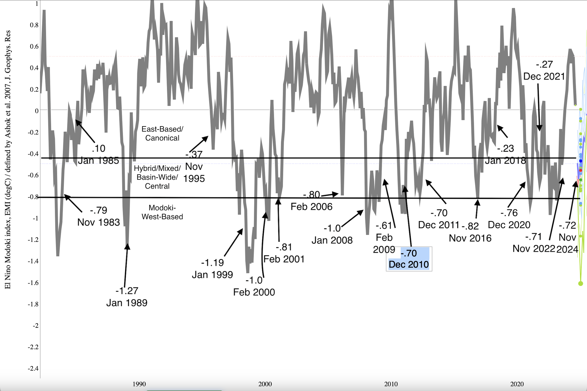
@snowman19 The fact that region 1.2 is so small skews the EMI away from heavily east based events....if you look at this graphic I made of EMI rankings since 1980, the only event in positive territory is 1985, but weakly positive (east-based) events are still considered east-based. The Jamstec ensemble mean forecast is most similar to 1995, 2017 and 2021.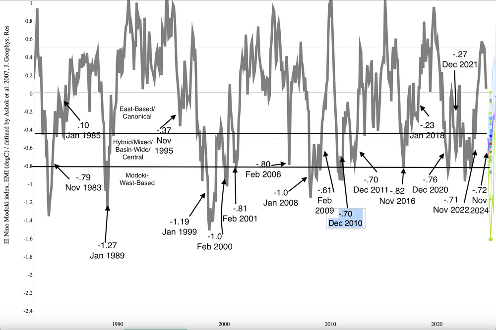
-
2025-2026 ENSO
40/70 Benchmark replied to 40/70 Benchmark's topic in Weather Forecasting and Discussion
It certainly doesn't argue for a Modoki. I agree that it isn't east-based in the sense that it matches up with the most extreme members of that grouping, but region 1.2 is so small that it doesn't weight the index much. When considering the subsurface cold pool is not below region 4 and is under region 3, the EMI would be biased slightly east, as the JAMSTEC data forecasts. I do agree that it isn't a huge deal since it will be so weak.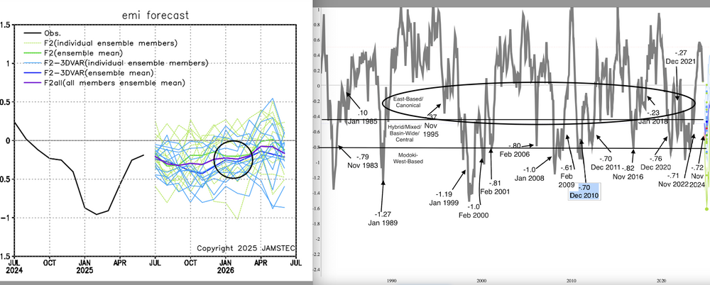
-
2025-2026 ENSO
40/70 Benchmark replied to 40/70 Benchmark's topic in Weather Forecasting and Discussion
Completely agree with your bolded take. -
2025-2026 ENSO
40/70 Benchmark replied to 40/70 Benchmark's topic in Weather Forecasting and Discussion
But he loves to call out the speculative posts of others from months earlier that didn't turn out to be correct...not to mention routinely make baseless claims of plagarism. Yea, he wasn't argumentative at all. I get @so_whats_happening's frustration with the bickering, but the his raindance reference was one of the least insightful posts in the entire thread given he was one of the more incendiary posters. I agree regarding the quality of his analysis for the most part. -
2025-2026 ENSO
40/70 Benchmark replied to 40/70 Benchmark's topic in Weather Forecasting and Discussion
I sense a quoted tweet from Mr. Miagi's nephew about how its been the 3rd hottest Summer in Japan in over 150 years of data, and the fish population is suffering. -
2025-2026 ENSO
40/70 Benchmark replied to 40/70 Benchmark's topic in Weather Forecasting and Discussion
I think November isn't as impacted by the expanding Hadley Cell because of the shorter wavelengths......once those lengthen, December has been more prone to the milder patterns until we are deep enough into the cold season to offset enough to allow for coastal snow. -
2025-2026 ENSO
40/70 Benchmark replied to 40/70 Benchmark's topic in Weather Forecasting and Discussion
The wave lengths are in flux at that time of year..I think that may be why. Easterly QBO and cool ENSO combos have had some active Decembers. -
2025-2026 ENSO
40/70 Benchmark replied to 40/70 Benchmark's topic in Weather Forecasting and Discussion
Not really, but I would still rather it not be Modoki all else equal. Plus you can never trust a cool ENSO HC alignment to not overperform in this regime. -
2025-2026 ENSO
40/70 Benchmark replied to 40/70 Benchmark's topic in Weather Forecasting and Discussion
It waned a bit last cold season, but its ramped back up. -
2025-2026 ENSO
40/70 Benchmark replied to 40/70 Benchmark's topic in Weather Forecasting and Discussion
I'm not saying we will see the snowfall March 2018 did, but I think it will be better than last year. March 2023 with a bit tamer RNA would nail most of SNE. -
2025-2026 ENSO
40/70 Benchmark replied to 40/70 Benchmark's topic in Weather Forecasting and Discussion
I think March will be more favorable than last year...I also think the cool ENSO event will be more east-based...last year was a Modoki. But that end of season PV disruption should be earlier than it was last year, more along the lines of 2023 and 2018. -
2025-2026 ENSO
40/70 Benchmark replied to 40/70 Benchmark's topic in Weather Forecasting and Discussion
My guts says you are right, but it will still be pretty destructive....I think there will be some heavy hitting home brews. -
2025-2026 ENSO
40/70 Benchmark replied to 40/70 Benchmark's topic in Weather Forecasting and Discussion
Yea, I mentioned that in my update last weekend. -
2025-2026 ENSO
40/70 Benchmark replied to 40/70 Benchmark's topic in Weather Forecasting and Discussion
Complete agreement...only matters for verification purposes. -
2025-2026 ENSO
40/70 Benchmark replied to 40/70 Benchmark's topic in Weather Forecasting and Discussion
That was before Understood mid level banding well...I remember I kept waiting for that band that came up from the tri state and was over the Berkshires to slide east, but of course it never did. I had about 16". -
2025-2026 ENSO
40/70 Benchmark replied to 40/70 Benchmark's topic in Weather Forecasting and Discussion
Like it was yesterday....I was in the Marines and flew home just to be there for PD II and I got caught in a subsidence hole. I almost swallowed my rifle I was so despondent lol 2'+ all around me and I had like a foot. The the same thing happened again 10 months later in December....so 2003 can Eff right off from a mesoscale standpoint, although I know it was favorable from a larger, synoptic scale perspective. -
July 2025 Obs/Disco ... possible historic month for heat
40/70 Benchmark replied to Typhoon Tip's topic in New England
I think he moved to Lunenburg -
2025-2026 ENSO
40/70 Benchmark replied to 40/70 Benchmark's topic in Weather Forecasting and Discussion
In this new, warmer climate, I don't see how we have a winter like 2002-2003 again unless all of our houses float away in a pool of molten lava. JK Chris....I do agree that the ship has sailed on that magnitude of sustained cold at this point.