donsutherland1
-
Posts
21,762 -
Joined
10 Followers


About donsutherland1

-
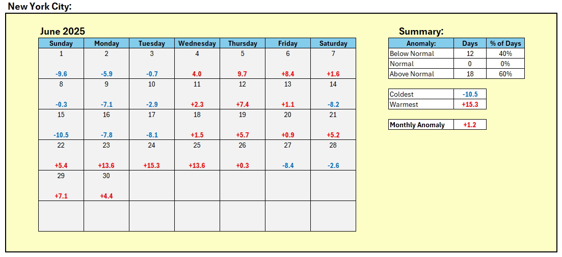
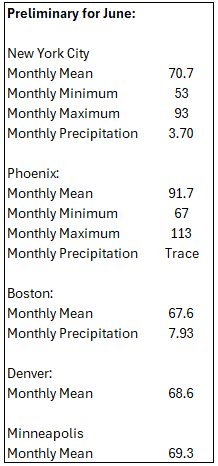
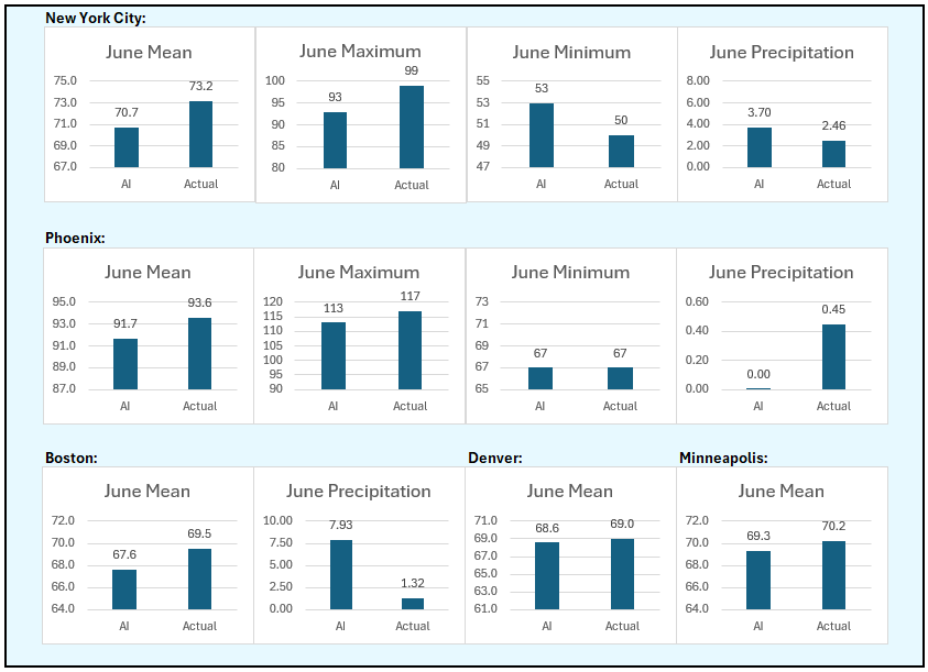
June Verification:
-
Final June numbers:
-
July 2025 Discussion-OBS - seasonable summer variability
donsutherland1 replied to wdrag's topic in New York City Metro
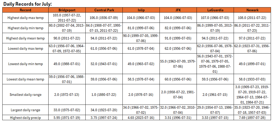
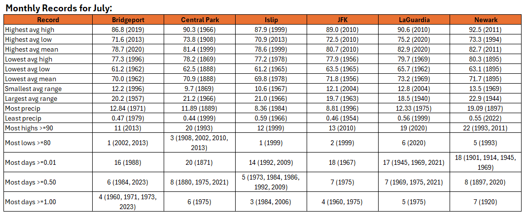
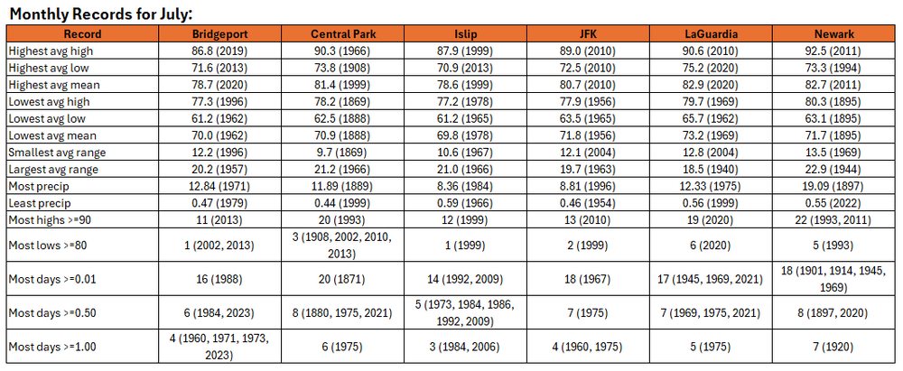
Almanac of July Records: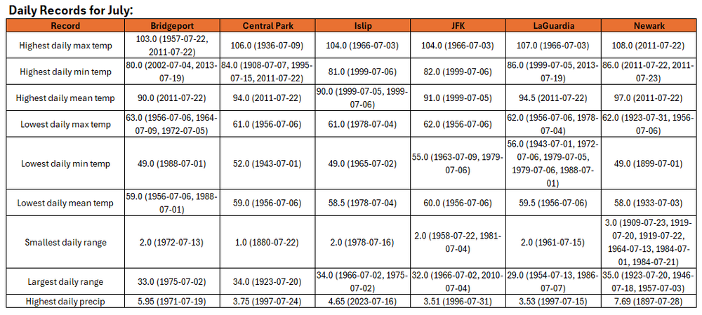
-
Central Park finally reached 90 this afternoon.
-
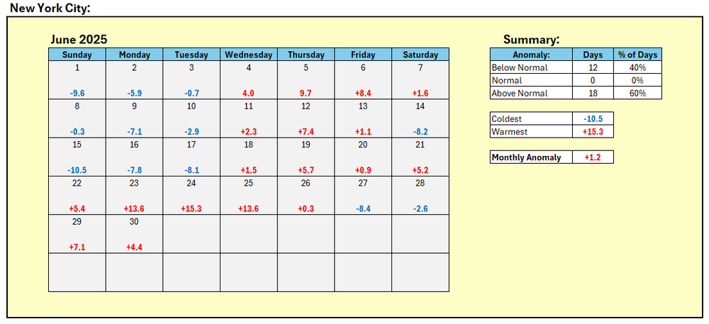
June ended on a hot note across much of the New York City area. High temperatures included: Islip: 89° New York City-Central Park: 90° New York City-JFK Airport: 90° New York City-LaGuardia Airport: 91° Newark: 93° New York City is finishing June with a monthly mean temperature of 73.2°. That is 1.2° above normal. June 2025 saw New York City's earliest 80° or above low temperature and an all-time record-tying 3 consecutive 80° or above lows during its heatwave on June 23-25. On June 9, the daily temperature range was just 2° (high: 64°; low: 62°), which tied the June monthly record set on June 8, 1869 and tied on June 11, 1910, June 8, 1916, June 20, 1958, and June 17, 1978. Overall, the June 23-25 heatwave was the most extreme on record for the larger New York City area. Islip (101°) and JFK Airport (102°) set new monthly high temperature records. Bridgeport, LaGuardia Airport, Newark, and White Plains all tied their monthly records. Very warm weather will prevail through mid week. New York City will see highs in the upper 80s. Newark will likely be near or just above 90° on each day during this period. Excessive heat does not appear likely to return through at least the first week of July. However, there is somewhat less certainty than yesterday. There remains some potential for a shot of more significant heat during the July 6-8 period. The ENSO Region 1+2 anomaly was +1.0°C and the Region 3.4 anomaly was 0.2°C for the week centered around June 18. For the past six weeks, the ENSO Region 1+2 anomaly has averaged +0.47°C and the ENSO Region 3.4 anomaly has averaged -0.03°C. Neutral ENSO conditions will likely continue through at least late summer. The preliminary Arctic Oscillation (AO) was +1.182 today.
-
Central Park finished at 90.
-
With JFK Airport's having reached 90° for the seventh time this month and New York City (Central Park) having a high of 89° so far, JFK Airport could wind up with four more 90° or above highs than Central Park this month. That would tie the largest difference when JFK had more 90° highs. The record was set in June 2010 when JFK had eight such days while Central Park had four.
-
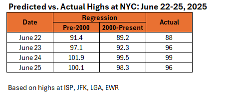
93 based on the pre-2000 regression equation.
-
89 so far.
-
Prior to June 2025, June 2019 (2 days at Islip and 1 day at New York City-Central Park) was the only such June. 2006 is currently the only year when Islip had more 90° days than Central Park (10 vs. 8).
-
Mountain West Discussion
donsutherland1 replied to mayjawintastawm's topic in Central/Western States
Today, Phoenix recorded its first 90° low temperature of the season. That is the fourth such occurrence on June 30th, which ties June 26th and June 29th for the second most occurrences in June. Only June 27th with five occurrences has more in June.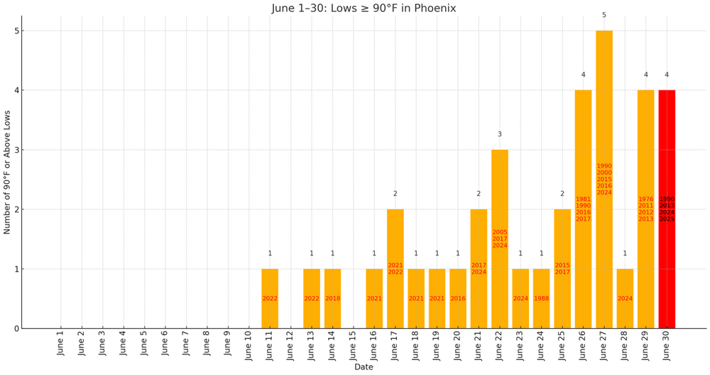
-
I’ve often seen the bald eagles along the Delaware River when I visit my sister in Milford.
-
DCA _ NYC _ BOS ___ ORD _ ATL _ IAH ___ DEN _ PHX _ SEA 1.5 1.5 1.5 1.5 1.5 0.5 0.3 1.2 2.4
-
I ran the numbers for June 24 using both regression equations: Pre-2000: 101.9; 2000-Present: 99.5; there's little doubt that absent the dense tree cover that was largely not present prior to 2000, Central Park would have surpassed 100° on June 24. Below are the predicted vs. actual highs for Central Park during June 22-25, 2025.
-
I reran the numbers, as the final data showed highs of 91 at ISP, 92 at JFK, 91 at LGA, and 95 at EWR to go with NYC's 89.