All Activity
- Past hour
-

October Comes Early: Late September Multi-Hazard Hybrid Storm
DirtySnowDen replied to WxWatcher007's topic in New England
Only reason k remember 3ff of snow is because, the precursor storm was plowing MLway above model expectations. -
 mexican prescription drug imports or mexican pharmacy that ships to usa purple pharmacy online https://images.google.lu/url?q=https://solmedsdirect.com mexican pharmacy online catalog or http://bbs.51pinzhi.cn/home.php?mod=space&uid=8381007 pharmacy mexico online order [url=http://reisenkaku-hotel.mfcms.jp/_m/index.php?a=free_page/goto_mobile&referer=https://solmedsdirect.com]mexican rx[/url] pharmacia mexico or [url=https://gikar.it/user/ayajlepanl/]farmacias mexicanas[/url] mexican pharmacy store reviews
 -

October Comes Early: Late September Multi-Hazard Hybrid Storm
Cobalt replied to WxWatcher007's topic in New England
Two things can be true at the same time. Take a look at the ocean temperature anomalies: Gulf of Mexico is far and away the warmest compared to average to date at the moment. Central Atlantic top 3, subtropic Atlantic top 5. That you can't deny without trying to discredit the satellite data. At the same time though, obviously shear is an overwhelming issue in the Atlantic basin, given that the El Nino is the most anomalous feature on the planet. But importantly, take a look at the ocean temperature anomalies nearer to this storm system. Surely that is promoting a stronger storm, and if you go back into the database, such anomalously warm waters only started showing up there more recently.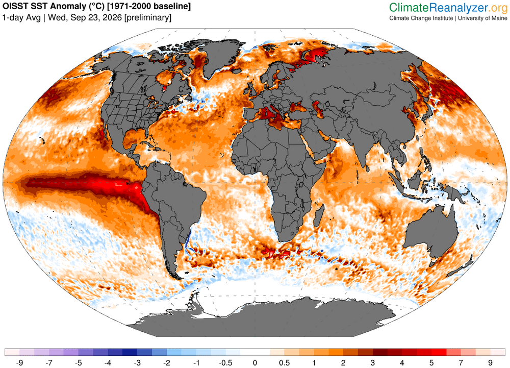
-
October Comes Early: Late September Multi-Hazard Hybrid Storm
DirtySnowDen replied to WxWatcher007's topic in New England
Remember “Nemo”? Convecfive feedback is what changed the area of highest impact 50 miles east from whom was supposed to jackpot. This is very similar. No one is gonna going to know till the beast is unleashed, and she’s just getting her tether. -
October Comes Early: Late September Multi-Hazard Hybrid Storm
DirtySnowDen replied to WxWatcher007's topic in New England
Granted, go-time is getting close, but the the dynamics of the beast are dynamics. -

October Comes Early: Late September Multi-Hazard Hybrid Storm
WinterWolf replied to WxWatcher007's topic in New England
Those numbers are so bogus…and a lot those warm water temps did for the zero hurricane season in the Atlantic to date. Wasn’t it supposed to be just the opposite? -
October Comes Early: Late September Multi-Hazard Hybrid Storm
DirtySnowDen replied to WxWatcher007's topic in New England
Not done yet “doing the shuffle.” -

October Comes Early: Late September Multi-Hazard Hybrid Storm
OrangeCTWX replied to WxWatcher007's topic in New England
0z NAM/ICON/GFS all show this turning left into NJ , sorta similar to what the EURO AI has been showing but slightly more south. Looks like we got our consensus. Congrats NJ -
.thumb.gif.f92b16c631a1d15d405ed77b33f0710d.gif)
October Comes Early: Late September Multi-Hazard Hybrid Storm
Torch Tiger replied to WxWatcher007's topic in New England
love that hrrr - minimal impacts here through Sat pm. -
October Comes Early: Late September Multi-Hazard Hybrid Storm
Cobalt replied to WxWatcher007's topic in New England
Why so? Their methodology seems rock solid and makes logical sense. -
October Comes Early: Late September Multi-Hazard Hybrid Storm
WinterWolf replied to WxWatcher007's topic in New England
Hailstoned hailstoned groan and boned…. -

October Comes Early: Late September Multi-Hazard Hybrid Storm
vortex95 replied to WxWatcher007's topic in New England
40-48 hr the 00z HRRR shows it taking on more ST characteristics w/ a more focused core wind field. RRFS does this but it take more than 24 hr after this time, and the low just meanders around to the S of us for the entire 84 hr period! Lots of time to do odds stuff! @WxWatcher007 I know will be closely tracking the exact sfc low position relative to the SSTs!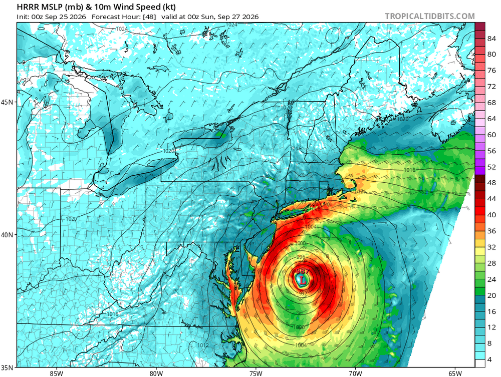
-
Get them here! https://www.ncei.noaa.gov/gibbs/
-
2026 Atlantic Hurricane Season
vortex95 replied to Stormchaserchuck1's topic in Tropical Headquarters
00z HRRR shows the E Coast low taking on more ST characterists 40-48 hr as a inner core contracted wind field develops. RRFS it take over 24 hr longer to do this.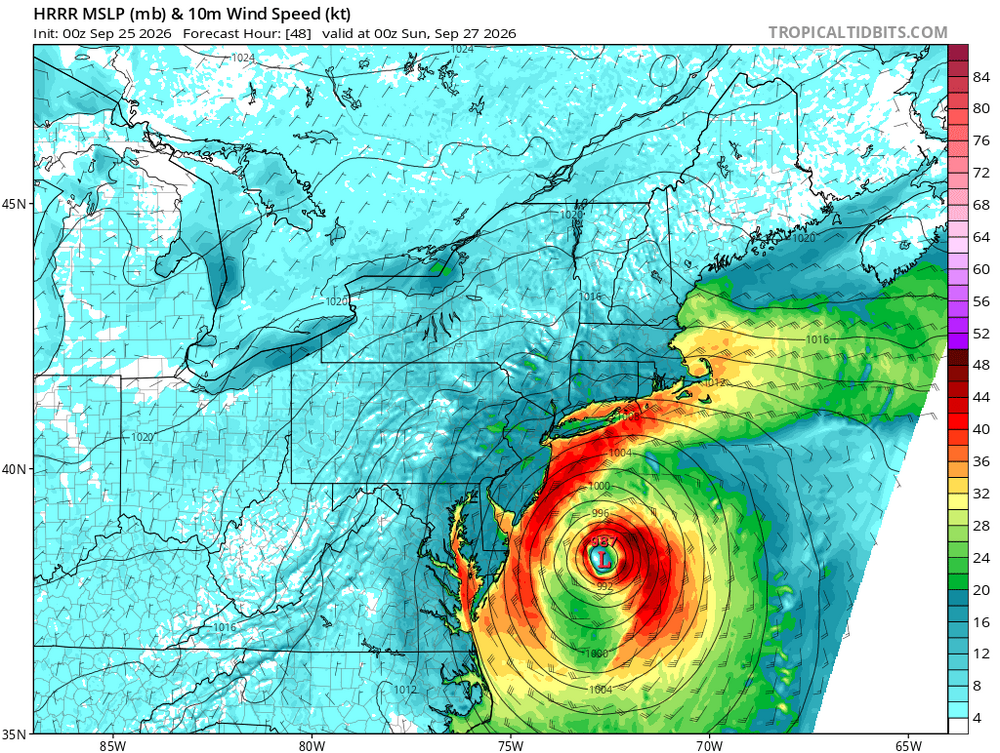
-
October Comes Early: Late September Multi-Hazard Hybrid Storm
DirtySnowDen replied to WxWatcher007's topic in New England
I’m thinking a soft, yet strong landfall on LI, doing its dance and meandering around BIS as it kaboots in its feeble state Monday. -
I got to give you props for pulling up this old satellite image!
-

October Comes Early: Late September Multi-Hazard Hybrid Storm
Hailstoned replied to WxWatcher007's topic in New England
trumpy, trumpy temper tantrum... -
October Comes Early: Late September Multi-Hazard Hybrid Storm
DirtySnowDen replied to WxWatcher007's topic in New England
Yes. - Today
-
October Comes Early: Late September Multi-Hazard Hybrid Storm
vortex95 replied to WxWatcher007's topic in New England
On Wed, five sites in ME/Quebec set all-time record high pressures for Sep. @CoastalWx take note. It's an exceptional pattern! Frenchville Montreal Quebec City Val D’Or Chibougamau-Chapais. -
October Comes Early: Late September Multi-Hazard Hybrid Storm
WinterWolf replied to WxWatcher007's topic in New England
You’re talking about the High? -
October Comes Early: Late September Multi-Hazard Hybrid Storm
DirtySnowDen replied to WxWatcher007's topic in New England
Last post for the night; it’s looking worse and worse for us. All depends on if it does a 50/50 split or a 40/60. -
online medicine shopping [url=http://geninduspharma.com/#]buy medicines online[/url] online chemists
-
Berlin mesonet site had a peak gust of 36 mph earlier today. Will be interesting to see how this storm plays out this weekend. Hope it's a sign of a decent winter incoming.
-

October Comes Early: Late September Multi-Hazard Hybrid Storm
Spaizzo replied to WxWatcher007's topic in New England
Next to the butt cheeks se of obx? . -

October Comes Early: Late September Multi-Hazard Hybrid Storm
Diggiebot replied to WxWatcher007's topic in New England
Winter storms we wait for the ticks east on game day