All Activity
- Past hour
-

July 2025 Discussion-OBS - seasonable summer variability
winterwarlock replied to wdrag's topic in New York City Metro
84/77/95 -

July 2025 Obs/Disco ... possible historic month for heat
kdxken replied to Typhoon Tip's topic in New England
84° / 72°. Perfect weather for morons. -
Lots of elevation as I remember. It was a nice course.
-

July 2025 Discussion-OBS - seasonable summer variability
SnoSki14 replied to wdrag's topic in New York City Metro
It's really crazy how different things feel with high vs low dews. I'll take 100+ with 50 dews over this crap any day -

July 2025 Discussion-OBS - seasonable summer variability
donsutherland1 replied to wdrag's topic in New York City Metro
I was told that it was an I.T. issue, but no further details were provided. -

July 2025 Discussion-OBS - seasonable summer variability
LibertyBell replied to wdrag's topic in New York City Metro
I just saw a live video of the Manhattan skyline, why does it look so POLLUTED and SMOGGY?? Is it because of trapped pollutants from car fuel exhaust?? Barely any visibility in the video I saw, meanwhile 25 miles to the east over here it's a very clear and deep blue sky with zero haze. -
I've never played Sky Meadow so have no idea what I am walking in to.
-
Ens guidance continues the idea of h5 ridge building out west for early August. For now it looks like we see below avg temps the first few days of the month then probably moderating to around avg. Could be some storms in the Aug 5-7 period if the GFS has the right idea, with some energy digging southward as the western ridge amplifies.
-
July 2025 Discussion-OBS - seasonable summer variability
LibertyBell replied to wdrag's topic in New York City Metro
are there power outages or something? what causes the intrahour issues? I think they missed a 90 degree reading in there, we hit 90 here a few days ago at 4:04 pm and JFK didn't catch it. -

July 2025 Discussion-OBS - seasonable summer variability
SACRUS replied to wdrag's topic in New York City Metro
Max temps for Jul (so far) all on 7/8 EWR: 100 LGA: 98 JFK: 93 NYC: 93 -
July 2025 Discussion-OBS - seasonable summer variability
SACRUS replied to wdrag's topic in New York City Metro
I hope the JFK reporting includes the intra hour readings today, would be ashame to miss some spikes between hours. Still dealing with BLM issues for over 2 months. -
 Avondale 2012 average temp = 54.4 / 2023 = 54.4 / 2024 = 54.6 - scary warming trend there!!
 -
July 2025 Discussion-OBS - seasonable summer variability
LibertyBell replied to wdrag's topic in New York City Metro
94-98 is the range I would go with and that's pretty good (and close to our July max of 95 which we hit earlier in the month.) -
July 2025 Discussion-OBS - seasonable summer variability
winterwarlock replied to wdrag's topic in New York City Metro
I think upper 90s in the hottest spots with full sun. Yesterday wasnt all that hot but I ended up surging late to 90...I dont think its as intense as the June scorch but would be surprised not to hit at least 94 today. -
July 2025 Discussion-OBS - seasonable summer variability
LibertyBell replied to wdrag's topic in New York City Metro
The only thing that interrupted that heatwave was a 3.25 inch deluge on Day 3, I wonder what kind of storm that was? That was almost a 15 day heatwave if you count the 89 the day before it started. -
July 2025 Discussion-OBS - seasonable summer variability
LibertyBell replied to wdrag's topic in New York City Metro
wow it shows that even low to mid 90s can be deadly, the length of that heatwave might be what made it so deadly. It's not on the list of longest NYC heatwaves though. Why was that heatwave in 1972 more deadly than the two longer and more extreme heatwaves in 1999 though? 1999 was second only to 1953 in heatwave length and extremes. -
July 2025 Discussion-OBS - seasonable summer variability
SACRUS replied to wdrag's topic in New York City Metro
In an otherwise cooler summer in reference to the deadly 1972 heatwave - it di feature an almost 2 week heat wave. Nothing exceptional but apparently this was a deadly heatwave in the mid atlantic / northeast EWR July 1972 Newark Weather Day High (°F) Low (°F) Precip. (inches) Snow (inches) July 1 84 64 0.00 0.0 July 2 91 71 0.00 0.0 July 3 91 72 0.14 0.0 July 4 79 65 0.00 0.0 July 5 68 61 0.10 0.0 July 6 75 59 0.00 0.0 July 7 78 60 0.00 0.0 July 8 78 63 0.13 0.0 July 9 79 61 0.00 0.0 July 10 89 67 0.00 0.0 July 11 91 69 0.00 0.0 July 12 91 73 0.00 0.0 July 13 78 71 3.25 0.0 July 14 92 73 0.00 0.0 July 15 95 76 0.00 0.0 July 16 90 77 0.00 0.0 July 17 92 75 0.74 0.0 July 18 90 78 0.00 0.0 July 19 95 78 0.00 0.0 July 20 90 74 0.11 0.0 July 21 93 73 0.19 0.0 July 22 92 75 0.00 0.0 July 23 96 79 0.00 0.0 July 24 90 80 0.00 0.0 July 25 91 72 0.01 0.0 July 26 80 66 0.00 0.0 July 27 81 68 0.00 0.0 July 28 81 68 0.00 0.0 July 29 81 66 0.00 0.0 July 30 81 69 0.00 0.0 July 31 73 69 0.03 0.0 -
July 2025 Discussion-OBS - seasonable summer variability
LibertyBell replied to wdrag's topic in New York City Metro
Oh nice I am going with this classification too. Hot is like a SECS (4-8 inches of snow) Strong heat is like a MECS (8 to 15 inches of snow) Extreme heat is like a HECS (16 to 29 inches of snow) Inferno is like a BECS (30 inches of snow plus) I would adjust strong heat to 95-99 and extreme heat to 100-104 though -
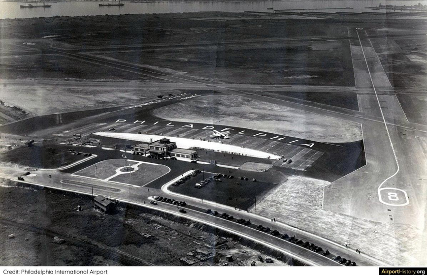
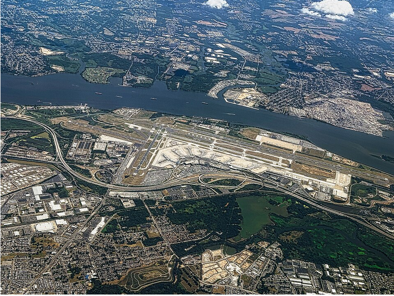
Or is it UHI at the Airport? 1940's vs today of the problem that is our PHL Heat Island.
-
July 2025 Discussion-OBS - seasonable summer variability
SACRUS replied to wdrag's topic in New York City Metro
0.16 -
July 2025 Discussion-OBS - seasonable summer variability
SACRUS replied to wdrag's topic in New York City Metro
Assuming hot is : 90 - 94 Strong heat : 95 - 98 Extreme heat : 99 - 104 Inferno : 105+ Id go in the strong heat category with a few hot spots at extreme heat. 850 MB temps 18C - 19C. -
July 2025 Discussion-OBS - seasonable summer variability
LibertyBell replied to wdrag's topic in New York City Metro
Yes, around here it's only been 5 days, we got about 30 minutes of a very heavy rain shower on the night of 7/20.... do you have the JFK total from that night Tony? -
July 2025 Discussion-OBS - seasonable summer variability
LibertyBell replied to wdrag's topic in New York City Metro
are we sure today's going to be all that hot? it's not even in the mid 80s here yet and the sky is a deep blue kind of clear sky, no haze like we usually see on very hot days and the temperatures are not rising quickly like they did in late June at this time. -
July 2025 Discussion-OBS - seasonable summer variability
SACRUS replied to wdrag's topic in New York City Metro
Im going on 10 days since last rainfall here Last rainfall for the following EWR: 7/14 NYC: 7/14 LGA: 7/14 JFK: 7/20 -
Beginning to wonder if the term 'heat wave' is the right nomenclature for that western Pac thermal anomaly. Heat wave implies a beginning, and then an end. There is no "wave" if whatever is occurring does not ascend and then descend, or vice versa. This thing? ascended gradually over the last 10 years and has been transfixed - if perhaps wobbling around .. Perhaps it the waved nature extends over multi-decade. Then we'd have to get into the philosophy of whether time range disqualifies a wave phenomenon and ugh... Anyway, it's not behaving like a wave. In fact, it smacks like a 30 years from now ...the mean will be adjusted up because of it's presence, and the "anomaly" will disappear in the arithmetic means once the moving climate calcs are reapplied. It's just the new order, in other words. Not saying that's the case ... but it's not acting like a "wave" nonetheless. As an after thought, it seems as GW's gone up, this thing's emerged almost in lock step with the last 20 years of the GW acceleration. Gets easier to assume there's a connection there but just supposition for now I guess.


