All Activity
- Past hour
-

Central PA Summer 2026 Discussion/Obs Thread
Mount Joy Snowman replied to Voyager's topic in Upstate New York/Pennsylvania
55 when I left the house. Love this time of year. -

Septorcher 2026 Discussion - Endless Summer
Brewbeer replied to Damage In Tolland's topic in New England
53/51 this "septorcher" morn' -

Septorcher 2026 Discussion - Endless Summer
kdxken replied to Damage In Tolland's topic in New England
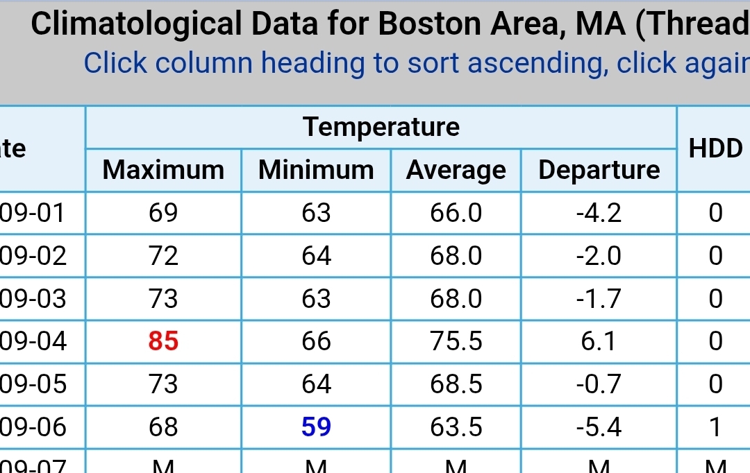
First HDD since the beginning of June. And so It begins.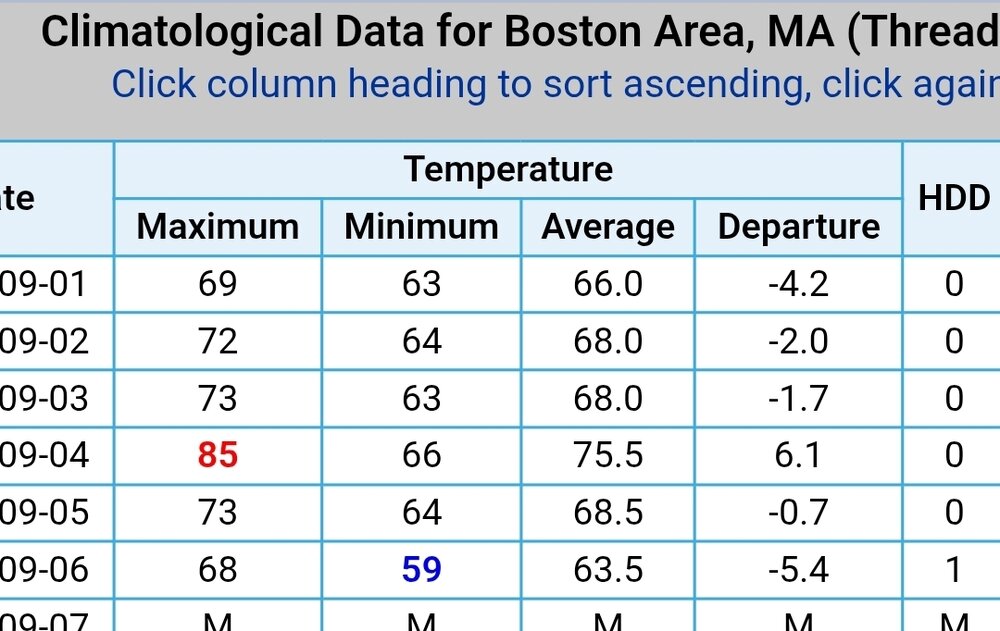
-
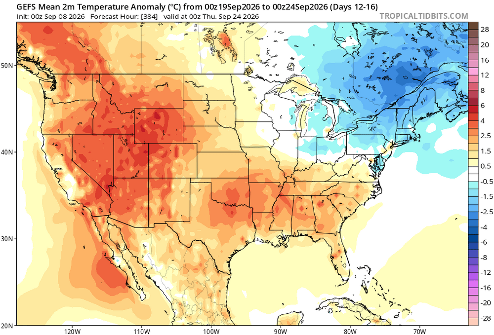
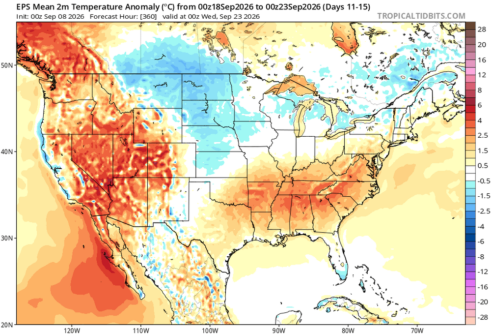
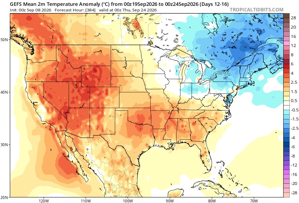
That's only the first 6 days of a 30-day month. It obviously didn't hold on to August's heat long enough. However, the changes are coming. Here are the 3 ensemble temp anomaly averages for the 5 days ending the 22nd/23rd of September. Needless to say, there's another 7 days in the month beyond this period to go into the mix. That's not to say the forecast will verify, because it may not. But I don't think using the first 6 days of the month for verification is predictive for a month.
.thumb.png.820317c1705a40c0bc9c2e1065fd6ad6.png)
- Today
-
A tad chilly out this morning!
-
.thumb.jpg.6a4895b2a43f87359e4e7d04a6fa0d14.jpg)
Central PA Summer 2026 Discussion/Obs Thread
Yardstickgozinya replied to Voyager's topic in Upstate New York/Pennsylvania
Taken from the Nws the forecast discussion. https://forecast.weather.gov/product.php?site=CTP&issuedby=CTP&product=AFD&format=CI&version=1&glossary=1&highlight=off By Wednesday night, a low pressure system will be moving across northern Ontario with a cold front extending south through the Great Lakes and Ohio Valley region. The pressure gradient will support an uptick in synoptic scale/gradient winds Wednesday afternoon into Thursday. Expect gusts into the 20s on the hilltops and also in the SE. A gust near 30MPH is possible on the tops of the Laurels Wed night just before the front. The cold front will spark SHRA/TSRA, with the majority occurring before the front passes later Wed night N and Thurs in the S. The risk for severe weather will depend on the magnitude of a shortwave trough racing through the region and any associated jet dynamics in play. Vertical wind profiles look unidirectional, so the primary hazard would be from damaging winds. Timing of the cold front and dewpoints largely staying out of the upper 60s to lower 70s range are the 2 main reasons to think storms will not get too crazy, unlike recent events. Timing of the cold front has been similar the last few days. SPC outlook currently has a MRGL risk area for Wed-night painted across the NW half of the CWA. Seems in line with previous forecasts. The new Day3 (Thur-night) outlook barely has the general thunder area into the CWA - basically along and S of the PA Turnpike. The current WPC outlook for Thurs paints a SLGT risk of excessive rainfall over the SW quarter of PA - including the Laurels. However, it will be difficult to squeeze out heavy rain without thunder/deep convection. So, we`ll chat with WPC about the threat risk. High pressure builds behind the cold front, giving way to a dry and sunny Friday. There could be a few PM SHRA/TSRA Saturday and/or Sunday afternoons, especially over the western mtns. A more-active (wetter) pattern is in store for Mon-Tues. But, the flat upper ridge over the southern half of the CONUS will make it difficult for deep moisture to make it into PA ahead of any shots of atmos forcing. The second half of the week probably ends dry as the upper ridge pumps up over the central CONUS. -
 buy cytotec pills: CytoCarePharma :: order cytotec online
 -
generic propecia pill or propecia cost of generic propecia without a prescription https://www.99entranceexam.in/docs/index.php?url=https://hairguardrx.shop get cheap propecia without dr prescriptionand http://www.garmoniya.uglich.ru/user/wupuydxglg/ buying cheap propecia without dr prescription [url=https://images.google.co.id/url?q=https://hairguardrx.shop]order cheap propecia tablets[/url] cheap propecia without a prescriptionor [url=https://brueckrachdorf.de/user/bgeknjxmdo/]cost propecia price[/url] cost of cheap propecia pill
-
tamoxifen and tamoxifen medication tamoxifen lawsuit https://maps.google.com.py/url?q=https://nolvacare.com how does tamoxifen work and https://mantiseye.com/community/zftrtixlje how to get nolvadex [url=http://www.google.com.pk/url?q=https://nolvacare.com]how does tamoxifen work[/url] tamoxifen men and [url=https://boyerstore.com/user/alppzhtshs/?um_action=edit]common side effects of tamoxifen[/url] effexor and tamoxifen
-
tamoxifen and tamoxifen medication tamoxifen lawsuit https://maps.google.com.py/url?q=https://nolvacare.com how does tamoxifen work and https://mantiseye.com/community/zftrtixlje how to get nolvadex [url=http://www.google.com.pk/url?q=https://nolvacare.com]how does tamoxifen work[/url] tamoxifen men and [url=https://boyerstore.com/user/alppzhtshs/?um_action=edit]common side effects of tamoxifen[/url] effexor and tamoxifen
-
https://hairguardrx.shop/# buy propecia without rx
-
tamoxifen and tamoxifen medication tamoxifen lawsuit https://maps.google.com.py/url?q=https://nolvacare.com how does tamoxifen work and https://mantiseye.com/community/zftrtixlje how to get nolvadex [url=http://www.google.com.pk/url?q=https://nolvacare.com]how does tamoxifen work[/url] tamoxifen men and [url=https://boyerstore.com/user/alppzhtshs/?um_action=edit]common side effects of tamoxifen[/url] effexor and tamoxifen
-

2026 C and E Pacific tropical activity
WxWatcher007 replied to GaWx's topic in Tropical Headquarters
-
cost generic propecia tablets: HairGuardRx - get propecia without dr prescription
-
cost generic propecia tablets: HairGuardRx - get propecia without dr prescription
-
cost generic propecia tablets: HairGuardRx - get propecia without dr prescription
-
cost generic propecia tablets: HairGuardRx - get propecia without dr prescription
-
Burst of deep convection in the last thirty minutes. Hopefully, that doesn't wrap around because it is crunch time.
-
^Thanks for posting the Molokaʻi radar. You can still make out the eyewall and does indeed look like Ni'ihau is going to take a rough hit regardless now. Also, the closer 88D site in Kauai that failed/went down earlier is very exposed on the southern coast. So it would have probably failed at some point regardless of issue. https://bsky.app/profile/kc5knd.bsky.social/post/3muy33554uk2v
-

2026 C and E Pacific tropical activity
gallopinggertie replied to GaWx's topic in Tropical Headquarters
Impressive winds on Kauai, with Lihue currently reporting 47 mph sustained gusting to 79. -
2026 C and E Pacific tropical activity
WxWatcher007 replied to GaWx's topic in Tropical Headquarters
Going to be extremely close for a eye pass, but an eyewall scrape will be rough. -
cytotec abortion pill and purchase cytotec cytotec buy online usa https://maps.google.co.ao/url?sa=t&url=https://cytocarepharma.com buy cytotec pills online cheap or http://la-maison-des-amis.com/user/ngywwqutcq/ buy misoprostol over the counter [url=https://www.anonymz.com/?http://cytocarepharma.com/]cytotec buy online usa[/url] cytotec online and [url=https://gikar.it/user/btroeqjyyq/]buy cytotec pills[/url] cytotec buy online usa
-
Most recent pass by recon:
-
The radar tower in Numila (PHKI) has been down for three hours. So we're running a bit blind beyond satellite. It's going to be very close whether the core or part of the eyewall clips Puuwai on the island of Ni'ihau. As mentioned before, modeling had us breathing too easy only to see guidance shift back east late in the game. I consider this a short-range failure in modeling, being that nearly all operationals and TC modeling had the core missing to the west somewhat comfortably no less than 48 hours ago. Again, you always hate to be on the eastern side of a chaotic trough interaction. Usually, if there are errors in a southwesterly steering flow setup, it's back towards the east if there is a correction.
-
Abortion pills online: CytoCarePharma :: п»їcytotec pills online


.png.3a300f47a0230a6705bc0321847189c5.png)