All Activity
- Past hour
-
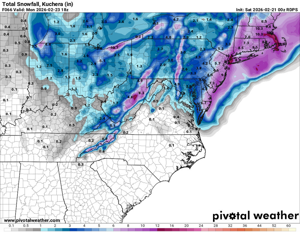
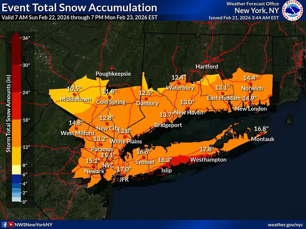
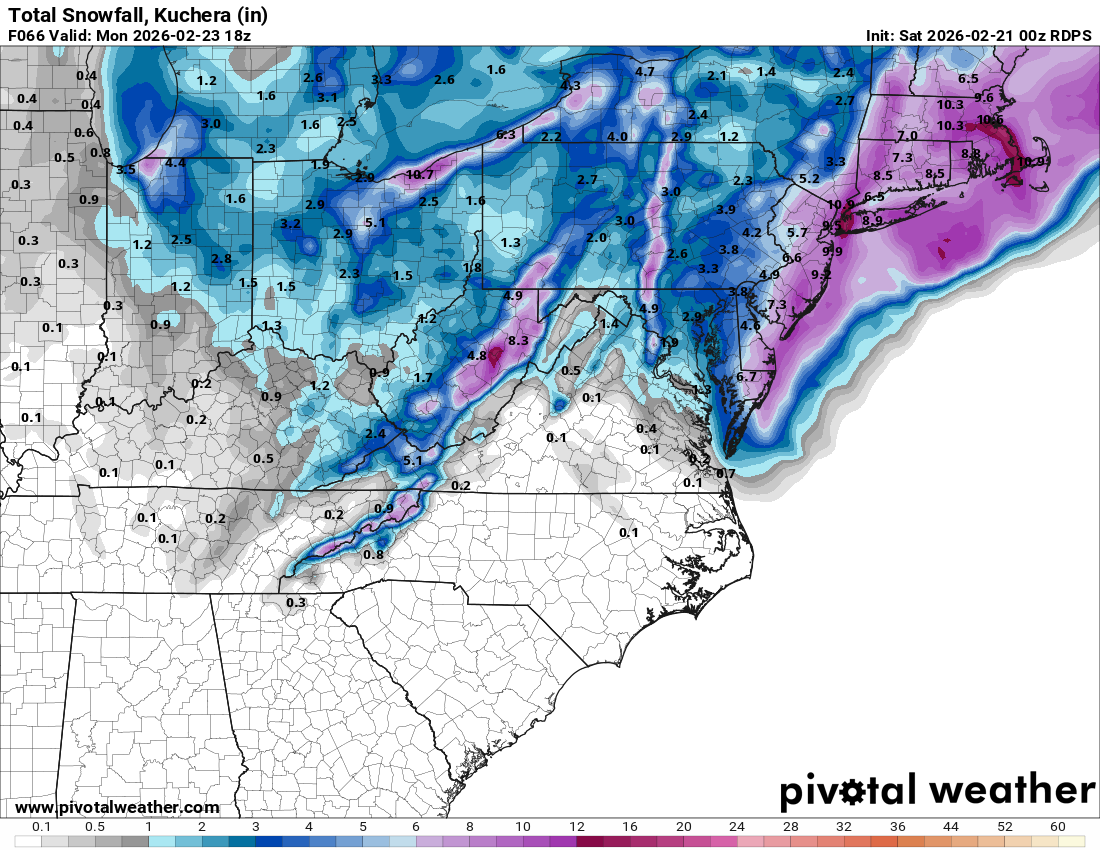
Area Forecast Discussion National Weather Service New York NY 421 AM EST Sat Feb 21 2026 .WHAT HAS CHANGED... Blizzard warnings have been issued for Long Island, New York City, and the Connecticut coast. Winter storm warnings have been issued for interior southern Connecticut, the Lower Hudson Valley, and northeast New Jersey. && .KEY MESSAGES... 1) An intense coastal storm will bring heavy snowfall and strong winds from Sunday into Monday. Blizzard conditions are expected along the coast with near-blizzard conditions across interior southern Connecticut, the Lower Hudson Valley, and northeast New Jersey Sunday night into the first half of Monday. 2) Potential for widespread moderate to locally major coastal flooding and dune erosion/overwashes Sunday night. Additional coastal flooding is possible on Monday. 3) Low pressure and a cold front will bring another chance for precipitation during mid next week. Temperatures rising into the 40s by the end of the week will allow for snow melt. && .DISCUSSION... .KEY MESSAGE 1... Confidence has increased to the point where winter storm and blizzard warnings have been issued across the forecast area. A major winter storm is forecast to impact the area Sunday into Monday. Model guidance has congealed in taking a deepening low off the Mid Atlantic coast Sunday northeast to near the 40N...70W benchmark Monday. This track is often favorable for all snow across the region. The low undergoes explosive deepening in 12h, tracking from near the North Carolina coast Sunday afternoon to east of the Delmarva Sunday night. Most of the guidance shows pressure falls on the order of 25 to 30 mb in 12 hour. The low deepens to around 970 mb as it approaches the benchmark Monday morning. This storm, expected to be early 1000 miles across in diameter, will produce heavy precipitation and gale to storm force winds over the adjacent coastal waters. Model soundings show boundary layer winds along the coast 40-60kt with decent mixing. Coastal locations can expect to see gusts up 40 to 50 mph, possibly even stronger across far eastern LI and southeast CT. Even inland area will see near blizzard conditions with winds just a bit weaker. The highest winds will occur Sunday night into the first half of Monday. Liquid equivalent amounts of around an inch across far NW portions of Orange county will be near an inch, with upward of an 1.5" at the coast. There is even some guidance suggestive of amount around 2 inches at the coast. However, while there is good overall agreement in the guidance, there still have been small adjustments east and west and a consenus forecast (blend of WPC and NBM) was used. Snow ratios are expected to start of around 10:1 and then possibly get up to 12-13:1. Temperatures initially on Sunday may get into the lower and mid 30s, expect most locations to fall to around freezing if not lower as the heavy snow develops in the afternoon. So ratios right off the bat along he coast may even be lower for a short time. Snowfall amounts of 14 to 18 inches are forecast along the coast with 10 to 14 inches across the interior. NBM deterministic forecasts point to amounts of 14 to 24 inches across the area, highest along the coast. But due to some wobbling of the low track a bit, we do want to see more continuity. NBM 90th percentile has amounts of 2 to 3 ft. The 00Z LREF (EPS, GEPS, and GEFS) mean has about a foot at the coast and 7 to 8 inches across far western sections of Orange County in the Lower Hudson Valley. The EPS is contributing lower amounts with a more eastern solution. Should it come a bit more west, than the higher totals are not out of the realm possibility. Snow is forecast to develop from SW to NE on Sunday, in the morning from NYC and points north and west, and the in the afternoon for the remainder of the area. The heaviest snow and wind will be Sunday night into Monday morning. Snow will end from west to east during the afternoon hours. .KEY MESSAGE 2... Strengthening E-NE winds Sunday into Sunday night could produce a surge of 2.5-3.5 ft, producing widespread moderate to locally major coastal flooding along the back bays of western Suffolk and srn Nassau, Peconic Bay, and western Long Island Sound, and widespread minor to locally moderate flooding in NY Harbor and Jamaica Bay, the lower Hudson River, and ern Long Island Sound. The main high tide cycle of concern is Sunday night. Areas of dune erosion are likely, with localized overwashes possible along the ocean beachfront Sunday night into Monday morning. Additional coastal flooding will likely linger into the Monday afternoon high tide cycle, with a strong northerly flow limiting impacts somewhat to minor/locally moderate categories.
-

“Cory’s in NYC! Let’s HECS!” Feb. 22-24 Disco
The 4 Seasons replied to TheSnowman's topic in New England
Thanks for watching over us -
“Cory’s in NYC! Let’s HECS!” Feb. 22-24 Disco
The 4 Seasons replied to TheSnowman's topic in New England
RGEM improved came NW but it was more of the SE models -

“Cory’s in NYC! Let’s HECS!” Feb. 22-24 Disco
WinterWolf replied to TheSnowman's topic in New England
Was in Quebec in the Gaspe’ peninsula until Wednesday night sledding…then we re entered the states, and saw you guys had it under control, so just lurked and kept quiet. I’m liking what I’m seeing though…very exciting to say the least. -

The February 22-23 Late Season Miracle: JV Disco/Banter Thread
dailylurker replied to bncho's topic in Mid Atlantic
Not at all. You just need to get your Airbnb location. As of right now my target is Fenwick Island, Del. Blizzard watches already up. -
“Cory’s in NYC! Let’s HECS!” Feb. 22-24 Disco
The 4 Seasons replied to TheSnowman's topic in New England
Missed u wolfie. You're the Yin to TBlizzs Yang. Balance is all out of whack. What happened no service up there? -
That's snowfall depth? I'll take $17 billion on the under please.
-
“Cory’s in NYC! Let’s HECS!” Feb. 22-24 Disco
WinterWolf replied to TheSnowman's topic in New England
Hi boys….I’m heading back from sledding this morning…let’s have a blizzard in SNE!!! -

“Cory’s in NYC! Let’s HECS!” Feb. 22-24 Disco
moneypitmike replied to TheSnowman's topic in New England
So much weather. I'll be hoping the wind will keep my clear of the 1-2" we'll be getting here. At this point, I think the ensembles can only be used for a sense of "is there room to move". Everything says the limit's been reached for low placement. QPF fields may still vary a little. -
Snip from the latest LWX AFD... Winter Storm Watches have been expanded along the remaining western shore of Maryland given a slight westward progression amongst the guidance. Overall the 00z model suite remains fairly consistent on the track of low pressure from the southeast U.S later today and off the Carolina coast tonight before shifting north toward the Delmarva coast Sunday afternoon into Sunday night. Some questions remain in how close to the coast the low pressure system is and it`s interaction with an inverted trough that looks to set up in the vicinity of the area Sunday evening into Monday. The 00z Canadian and European solutions continue to trend a little closer to coast with the low pressure system similar to the NAM/GFS counterparts. Even with that said, the low still remains 200-400 NM away from Washington DC and Baltimore, pulling the bullseye of substantial snow toward areas east of the I-95 corridor. Precipitation is expected to develop across the area predawn Sunday morning on the north side of developing surface low pressure to the southeast. It should be initially fall as rain or rain/snow mix as the low-levels will be too warm. In addition, the precipitation intensity initially will be light, so that any snow that falls will have a difficult time accumulating on roads other than grassy areas or at high elevations above 1500 feet. Most of the Sunday should be wet with a snow/rain mix falling at temperatures around 34 to 38 degrees. Any impactful snow (especially to road surfaces) looks to hold off until late Sunday evening into Monday morning. Lows Sunday night into Monday will fall close to freezing with teens and 20s over the mountains. This is when low pressure deepens off the coast and the upper level trough/inverted surface trough swings through. The wild card here is the interaction between these features with most of the guidance showing a narrow corridor of strong lift between central/northern MD down through northern VA and into the VA northern neck. This area seems to have the least amount of uncertainty with respect to QPF according to the latest 00Z EPS/GEFS ensembles with QPF amounts generally around three quarters of an inch liquid equivalent. While snow ratios will likely BE lower than normal (less than 10:1 especially to start), potential banding may offset lower ratios and more marginal temperatures Sunday night into Monday morning as colder air pushes in. General model consensus remains at a widespread 2 to 5 inches of snow along and north of I- 66/US-50 with lesser amounts in the Shenandoah Valley/central VA Piedmont and higher amounts along the western favored slopes of the Alleghenies as well as east of I-95. The probabilities for 4" of snow remain between 60 and 80 percent over the Alleghenies/crest of the Blue Ridge with 40-50 percent probs further east into the metro areas. These numbers come down into the 35 to 45 percent range for 6" with the highest percentages over the mountains and east of the I- 95 corridor. Any wiggle in track and placement of the inverted trough could move the needle up or down for these totals. Given the variability any warning or advisory decisions will likely be made on the day shift today or at the latest this evening. The snow will likely continue through Sunday night before tapering in intensity or exiting the area around daybreak Monday. Gusty NW winds 25-40 mph) will follow Monday in the wake of the storm. Elsewhere, light snow is expected Sunday night tapering off after midnight from west to east, except in the mountain areas where upslope flow will continue to generate snow showers. Highs Monday warm back into the mid 30s and low 40s outside the mountains. Overnight lows Monday night fall back into the teens and low 20s and cold air advection returns in the wake of the system.
-

The February 22-23 Late Season Miracle: JV Disco/Banter Thread
AmericanWxFreak replied to bncho's topic in Mid Atlantic
Well this sucks… we’re really gonna lose this one eh? -
Was talking in general not imby lol
-
06Z RGEM Kuchera snow vs. 00Z totals. Still rather conservative (surface thermals) and mainly late afternoon into Sunday night. Areas in between the monster bands near the Atlantic Coast and the inverted trough band west could very well get sub-warning criteria snow given the weaker rates and marginal thermals.
.thumb.png.3e04d433c55d8847a539d177b4b62028.png)
-
“Cory’s in NYC! Let’s HECS!” Feb. 22-24 Disco
The 4 Seasons replied to TheSnowman's topic in New England
we're gonna get whacked -
I was gonna say 8-12 but that works too .
-
Rgem is snowier than 0z
.thumb.png.0aa9b53f7318b1f2e48c208241ffc847.png)
-
I think a good starting point is 6-12.
-
Don't get carried away. The euro shows much less, particularly in western areas.
-

“Cory’s in NYC! Let’s HECS!” Feb. 22-24 Disco
Roger Smith replied to TheSnowman's topic in New England
So 6" for the thread starter? (jk) That map looks very plausible to me, will see if 06z GFS changes my opinion. -
Get the euro on board.
-

“Cory’s in NYC! Let’s HECS!” Feb. 22-24 Disco
40/70 Benchmark replied to TheSnowman's topic in New England
"Therrreees the Demon"...I definitely invoked Bruce's spirit last night. -
Whats scary is that might be conservative. Good start.
-
“Cory’s in NYC! Let’s HECS!” Feb. 22-24 Disco
The 4 Seasons replied to TheSnowman's topic in New England
"East facing slopes of the Worcester Hills...30...35...possibly 40 inches!" -
Upton all in
-
“Cory’s in NYC! Let’s HECS!” Feb. 22-24 Disco
40/70 Benchmark replied to TheSnowman's topic in New England
https://easternmassweather.blogspot.com/2026/02/severe-winter-storm-imminent-sunday.html First Call:


.png.64150311c1c660a23619ba2a75e186ec.png)


.png.e69562e69ee6fa7124b27575dd6c6cdc.png)


