All Activity
- Past hour
-
Big shift west hopefully the better models do also
.thumb.png.5eebcd924fdda7348d4d090f53cae7ca.png)
-
 Thanks Don, I figured as much, 1948 was not very hot outside of that extreme heatwave near the end of August (I wonder why it happened, there must have been some very anomalous pattern in place. The only other time NYC had three 100+ days in a row was in 1993 and that was a hot summer from beginning to end, very different from 1948.) Don, when you have some time could you do a chart like this for NYC too? I think the top summers would be 2010, 1993, 1991, 1949 and 1983.
 -
 Who knows. My neighbor 2 doors down has 3 show dogs (smooth collies). For some reason, she has them outside all the time and they bark at everything. It is so annoying. There is no reason why 70 pound dogs need to go out every few hours.
 -
.thumb.png.d9671c233f2ee3469207f01b42e2579c.png)
-
 It's highly unlikely. Both LGA and Central Park had too few 90° or above days during 1948 and the summer mean was 0.4°-0.5° below that of 1949. Using just the 1948-2024 period, 1948 ranked 13 spots below 1949 at LGA and 19 spots below Central Park.
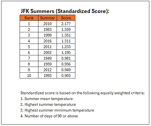
-
86/70. It's going to be a little warm at great adventure.
-
Maybe they're barking at some animal outside that they hear or smell but humans can't? edit-- oh you mean there are dogs outside they're barking at?
-
Its really close
-

INVEST 98L - Possible TD before inland later today
GaWx replied to BarryStantonGBP's topic in Tropical Headquarters
Per elsewhere Special TWO drops it to 20/20 so looks like it's not going to happen. -
Thanks Don, it makes the difference between 1983 and 1999 a little more. 2010 is still well ahead of the rest though.
-
Going to be east on the ICON but that wouldn't take much
-
I cleaned up my typos. 1983 would remain second, but the difference between 2010 and 1983 would narrow were September added.
-
.thumb.png.7fb4c8650272174ed62f08a072927077.png)
-
Thanks Don.... I think 2016 has our new record for 75 degree dew point days, the previous high water mark was 1983 which had the most 90 degree days (until 2010) and the most 75 degree dew point days (until 2016.) I see you mentioned that even though 1948 had its extreme 100 degree heatwave in late August it can't be included because of missing data from earlier in the summer. Is there any way to project what its ranking and score would be by using LGA and NYC to fill in the missing data? Would it make the top 10 do you think Don?
-
Yeah. We’ll be getting warm/AN/hot stretches for a while. Next week will feel nice but my pool will cool down again.
-
Records:Highs:EWR: 99 (1988)NYC: 97 (1988)LGA: 97 (1985)JFK: 98 (1988) 1988 was incredibly hot in August 1988 - Thirty five cities in twenty states in the north central and northeastern U.S. reported record high temperatures for the date, including Lamoni IA and Baltimore MD, where the mercury hit 105 degrees. Temperatures 100 degrees or above were reported in twenty-two states. Pierre SD was the hot spot in the nation with a high of 114 degrees. Bluefield WV reported eight straight days of record heat. (The National Weather Summary) 1993: Slow moving thunderstorms produced torrential rain across Mower County, MN. Rainfall exceeded 4.00" over most of the county with the highest total of 10.25" at Adams, MN. Significant flooding occurred within the city of Austin, MN, where 1,000 homes suffered water damage. The Cedar River in Austin rose rapidly out of its banks through the day. It crested at 21.3 feet, 6.3 feet above flood stage. (Ref. Wilson Wx. History) endless flooding in the MW in 1993 while we had our endless summer here
-
Adding September would still leave 1983 in second place, but the gap would narrow. The top five from most extreme to less extreme would be: 2010 (2.188), 1983 (1.762), 1999 (1.614), 2016 (1.297), and 2002 (1.232).
-
Wow!
.thumb.png.4f054e919a2ce5804d11c130bc2efb8b.png)
-

INVEST 98L - Possible TD before inland later today
WxWatcher007 replied to BarryStantonGBP's topic in Tropical Headquarters
Yeah that doesn't look like a TC to me despite the southwesterlies. That was a quick trip by recon lol. 98L is out of time. -
Yes 2005 was extremely hot too but lower number of 90 degrees here because of the onshore flow. 2005 was similar to 1988 in that respect. Look how high 1949 ranks on almost every chart, I find that absolutely incredible lol. The rise in summer temperatures isn't a straight line, it's stair step and then a leveling off happens for a few years before the next rise. For us it's been 1949 and then 1983 and then 2010.
-
In traction maybe?
-
Yup history pretty much slams the door in this being a threat to us. Hopefully we can summon some home grown which would make things slightly easier
-
higher humidity may carry more heat but it lowers the temperature during the day while pushing it up at night.
-
1983 set the record for most 90 degree days and 75 dew point days at JFK before the 2010s.
-
Back isn’t broken. Maybe some spasms.

.png.6151ca091d04c960e0abc0edc90ca35b.png)


