All Activity
- Past hour
-

2026-2027 El Nino
40/70 Benchmark replied to Stormchaserchuck1's topic in Weather Forecasting and Discussion
I knew you would call sample size Well, once we get a big NE winter with a 2.1+ El Niño, I'll capitulate. -
2026-2027 El Nino
40/70 Benchmark replied to Stormchaserchuck1's topic in Weather Forecasting and Discussion
No argument there....highly doubt it averages negative for the season next year. -

2026-2027 El Nino
Stormchaserchuck1 replied to Stormchaserchuck1's topic in Weather Forecasting and Discussion
But why would the same thing change if it's 0.5 or 2.0? -
2026-2027 El Nino
Stormchaserchuck1 replied to Stormchaserchuck1's topic in Weather Forecasting and Discussion
Not enough examples. 91-92 is the only west-based event 2.0 or greater. 15-16 was the only basin wide. 0/1 and 0/1.. the rest were east-based -
2026-2027 El Nino
40/70 Benchmark replied to Stormchaserchuck1's topic in Weather Forecasting and Discussion
I'm not arguing the pattern doesn't look different....I'm arguing it doesn't really matter if ENSO gets that powerful. -
2026-2027 El Nino
40/70 Benchmark replied to Stormchaserchuck1's topic in Weather Forecasting and Discussion
No, until you find me a +ENSO north of 2.0 that offered a favorable outcome for winter enthusiasts, it's factual. -
2026-2027 El Nino
Stormchaserchuck1 replied to Stormchaserchuck1's topic in Weather Forecasting and Discussion
Most strong events have the N. Pacific low further east.. over the North Pacific High region. You can see by that composite that the N. pacific low was actually pretty west that Winter. -
2026-2027 El Nino
40/70 Benchmark replied to Stormchaserchuck1's topic in Weather Forecasting and Discussion
Most strong El Niño events give you +PNA....excessively strong El Ninio usually has a dearth if high. latitude blocking.....again, not surprising. -
NOUS61 KPHI 301225 FTMDIX Message Date: Mar 30 2026 12:25:12 Critical maintenance will be conducted at KDIX through April 3. The radar will be down from approximately 12 to 21Z daily through Friday.
-
2026-2027 El Nino
Stormchaserchuck1 replied to Stormchaserchuck1's topic in Weather Forecasting and Discussion
We are still in that +1-5 year from Solar Max window. You will say the NAO wasn't that bad last Winter, but the average of the last 14 months is very ++ -
2026-2027 El Nino
Stormchaserchuck1 replied to Stormchaserchuck1's topic in Weather Forecasting and Discussion
That 2.0 stuff is superstition. Mechanics of something doesn't change if it gets stronger. If a car that normally drives 40mph goes 100mph, it goes 100mph, not more left or right. -
2026-2027 El Nino
Stormchaserchuck1 replied to Stormchaserchuck1's topic in Weather Forecasting and Discussion
I don't agree.. the forcing is on where the Hadley Cell and mid latitude cell meet, and that forcing is north of the El Nino.. west-based strong event gives you strong +PNA. You can actually see by the composite of that cold season that we did get +PNA, it was just mixed with +EPO/+AO/+NAO -
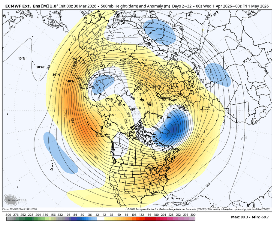
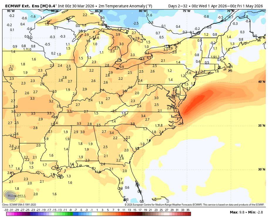
This has worked out great for the last 5 months... this is April before a later in the year El Nino March 2026 is going to beat 2012 as the warmest March on record for CONUS. The heat lingered in 2012: This is what my April forecast would look like
-
2026-2027 El Nino
40/70 Benchmark replied to Stormchaserchuck1's topic in Weather Forecasting and Discussion
NAO is probably going to be crucial this year, assuming ENSO does remain at or below 2.0, which I believe that it will. -
2026-2027 El Nino
40/70 Benchmark replied to Stormchaserchuck1's topic in Weather Forecasting and Discussion
Looking a the data, 2.0 is a pretty crucial threshold....you still have a fighting chance until you get over 2.0, then it's lights out. 1957 halted right at 2.0. -
2026-2027 El Nino
40/70 Benchmark replied to Stormchaserchuck1's topic in Weather Forecasting and Discussion
I don't understand why it's so surprising that 1991-1992 was warm because it was such a a powerful El Niño, hardly weaker than 2015. It doesn't matter whether it's east or west when it gets over 2.0. It was significantly more powerful than 2009 and 2002. -
67 here for the high. Sweating a bit while walking our very energetic dog
-
KDIX hit by a Shahed 136
-
18 degrees 2 days ago, and today a new record high of 85 at MLI.
-
We did hit 70.
-
Weenies hangin’?
-

Central PA Spring 2026 Discussion/Obs Thread
canderson replied to Voyager's topic in Upstate New York/Pennsylvania
Just hit me we probably don’t get below freezing again until late next October or November. Ugh. -
Pretty interesting in the Pacific as a Kelvin wave gets going this April. This is what 500mb looked like before our strongest 5 El Nino's on record: Nice match south of the Aleutians and NW of Hawaii
- Today
-
March 2026 will be one of the most +NAO's on record. History says hold on a second on it being such a warm April. This is what typically follows: Now models do say it will be a really strong +NAO April 1-15. If that happens, this is what the 1st half of April looks like:
-
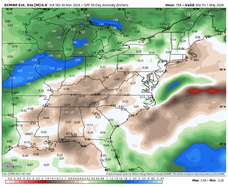
Latest WB Euro weeklies forecast April to be warm with normal to below normal precipitation.