All Activity
- Past hour
-
Knocking on my door here in Copiague. Bring it!
-
-

"Don’t do it" 2026 Blizzard obs, updates and pictures.
CoastalWx replied to Ginx snewx's topic in New England
Congrats Mattapoisett. -
Loving it rn brother.!!.enjoy!!.
-

"Don’t do it" 2026 Blizzard obs, updates and pictures.
ineedsnow replied to Ginx snewx's topic in New England
Much better comparing to 0z but looks to still be catching up.. we blizzard -

"Don’t do it" 2026 Blizzard obs, updates and pictures.
weatherwiz replied to Ginx snewx's topic in New England
Waking up nude
-
The only other time I've seen snow fall like this was in lake tahoe, CA.
-
Insane stuff happening on the east end
-
I've been saying 17" since friday.... i think i'm gonna nail it
-

"Don’t do it" 2026 Blizzard obs, updates and pictures.
bristolri_wx replied to Ginx snewx's topic in New England
3K mostly agrees... -
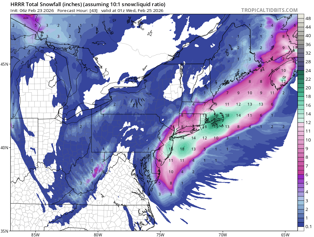
Difficult to say with certainty but also getting measurements between 10 and 12 inches. 10-12 was my personal final call on Saturday but the NWS forecast is looking pretty good right now.
-
Are these Long Island bars bands not gonna make it anymore west?
-
30 inches are not fetched for some areas,especially those who already have 14 to 16 inches of snow already. Add another 14 to 15..thats 28 to 31 inches.
-
"Don’t do it" 2026 Blizzard obs, updates and pictures.
bristolri_wx replied to Ginx snewx's topic in New England
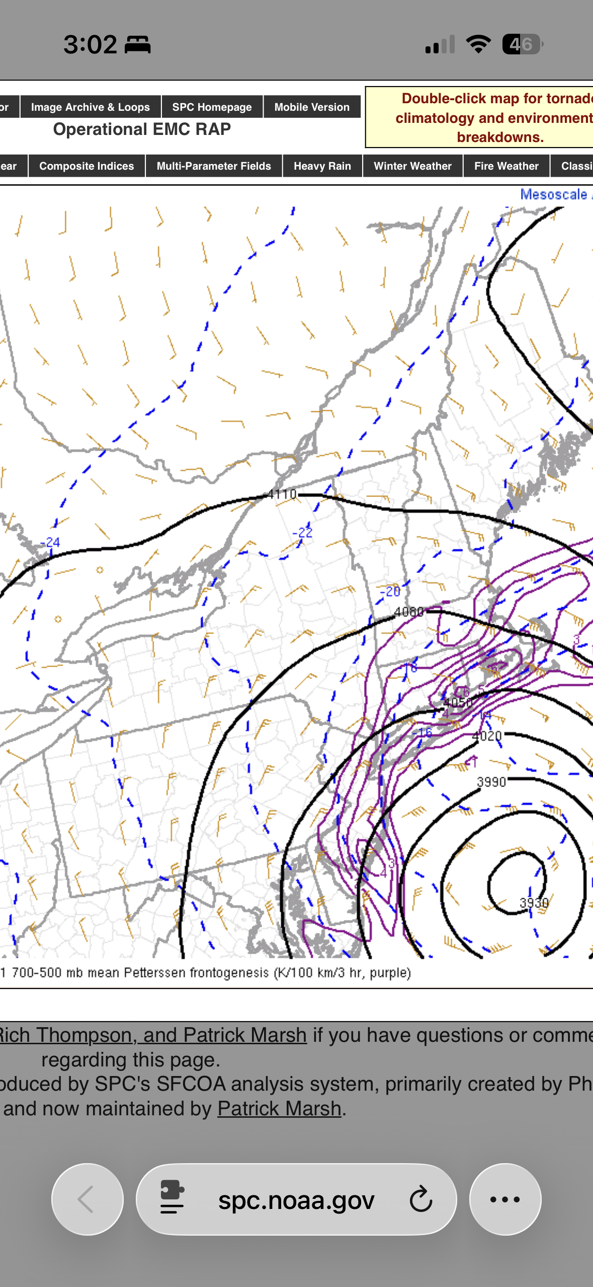
Damn straight. I have like 10 tabs open. BOX, OKZ, Regional Mosaic, Sub-Regional Mosaic, and the SPC Hourly Mesoscale Analysis map of 850 - 700 frontogenesis. But still looking at models too, with 15 hours to go on this storm. -
Absolutely insane outside. Wow.
-
Took a look out my window uphill from DCA. Looks like around an inch and a half stuck to tree branches and car tops. My Hill of Doom got covered, but it looks like Arlington came through and salted the center of the roadway into submission. Sidewalks vary. Some partially or fully resisted, others did not.
-

Blizzard of 2026 Storm Thread/OBS
LowerBucksWx replied to Mikeymac5306's topic in Philadelphia Region
No jinx but starting to feel like we may be a lock for 24+ in SE Bucks, or very close at least. -
"Don’t do it" 2026 Blizzard obs, updates and pictures.
CoastalWx replied to Ginx snewx's topic in New England
Holy nams -

-

"Don’t do it" 2026 Blizzard obs, updates and pictures.
40/70 Benchmark replied to Ginx snewx's topic in New England
28.9...falling steadily. 1.5" -
"Don’t do it" 2026 Blizzard obs, updates and pictures.
bristolri_wx replied to Ginx snewx's topic in New England
That being said - the NBM showed 30" right before go time. If that doesn't come close to fruition, NOAA/NWS really needs to take a look at what inputs it's using for snowfall. It's supposed to be one of the primary tools they use for issuing forecasts, from what I've read. -
"Don’t do it" 2026 Blizzard obs, updates and pictures.
40/70 Benchmark replied to Ginx snewx's topic in New England
How about just checking the 08z radar? Word on the street is it has a great handle on what is happening -
"Don’t do it" 2026 Blizzard obs, updates and pictures.
Thunderblizzard replied to Ginx snewx's topic in New England
Ripping and wind increasing further here. That band going into SE CT looks absolutely gnarly. -
"Don’t do it" 2026 Blizzard obs, updates and pictures.
CoastalWx replied to Ginx snewx's topic in New England
Few inches out there and 31.7. Hope that real heavy stuff comes -
HRRR has us snowing until 20z which i think is 4PM