
All Activity
- Past hour
-

Strong Nor'Easter/Hybrid Storm Late September 2026
wthrmn654 replied to Rjay's topic in New York City Metro
58mph I had to look up again -

Strong Nor'Easter/Hybrid Storm Late September 2026
Rjay replied to Rjay's topic in New York City Metro

-
Strong Nor'Easter/Hybrid Storm Late September 2026
wthrmn654 replied to Rjay's topic in New York City Metro
You know is simply the euro baiting everyone to rage after its been here all week saying hi hello, doesn't anyone believe me? Oh now you wanna believe me? Well screw you watch this! -

Strong Nor'Easter/Hybrid Storm Late September 2026
Brian5671 replied to Rjay's topic in New York City Metro
I think 60? -

October Comes Early: Late September Multi-Hazard Hybrid Storm
kdxken replied to WxWatcher007's topic in New England
Friend of mine has a place right on the water in Orleans. He got his boat out but his knucklehead kids left the kayaks on the shore. -
October Comes Early: Late September Multi-Hazard Hybrid Storm
kdxken replied to WxWatcher007's topic in New England
Woodyard. 17 miles south west of boston. Always get smoked by coastals. Ugh -
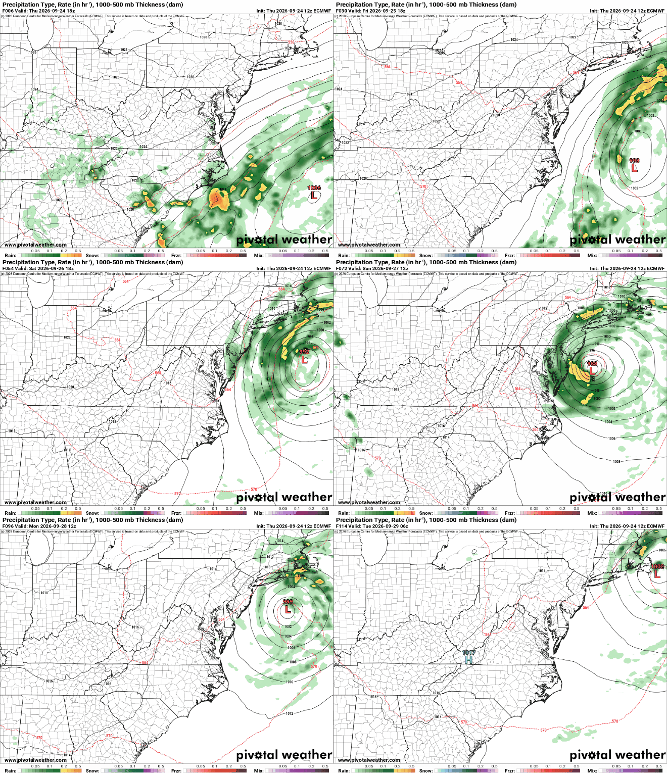
12Z Euro and our rapidly-aging uncle the NAM Nest definitely give credence to the idea that at least a chunk of our weekend will be messy.
-

October Comes Early: Late September Multi-Hazard Hybrid Storm
CoastalWx replied to WxWatcher007's topic in New England
I will say the euros was a long duration coastal battering. Tides get higher until Monday too. -
Strong Nor'Easter/Hybrid Storm Late September 2026
Rjay replied to Rjay's topic in New York City Metro
Maybe the rrfs isn't on crack lol
-

October Comes Early: Late September Multi-Hazard Hybrid Storm
weatherwiz replied to WxWatcher007's topic in New England
just wear a goalie mask and wear a baseball glove just in case. Personally though I'd be playing dodge that apple and if I get hit...so be it -

Strong Nor'Easter/Hybrid Storm Late September 2026
Tatamy replied to Rjay's topic in New York City Metro
Thank you. -
Strong Nor'Easter/Hybrid Storm Late September 2026
wthrmn654 replied to Rjay's topic in New York City Metro
Aren't gusts to 55 mph high wind criteria? -
It looks like it was during high tide. I’ll head out there tomorrow morning at high tide and get a photo or two.
-
Strong Nor'Easter/Hybrid Storm Late September 2026
Rjay replied to Rjay's topic in New York City Metro
Euro doing loops -
Strong Nor'Easter/Hybrid Storm Late September 2026
wthrmn654 replied to Rjay's topic in New York City Metro
URGENT - WEATHER MESSAGE National Weather Service New York NY 229 PM EDT Thu Sep 24 2026 CTZ007>012-NYZ071>075-078>081-176>179-271000- /O.NEW.KOKX.WI.Y.0003.260925T1800Z-260927T1000Z/ Northern Middlesex-Northern New London-Southern Fairfield- Southern New Haven-Southern Middlesex-Southern New London- Southern Westchester-New York (Manhattan)-Bronx-Richmond (Staten Island)-Kings (Brooklyn)-Northwest Suffolk-Northeast Suffolk- Southwest Suffolk-Southeast Suffolk-Northern Queens-Northern Nassau-Southern Queens-Southern Nassau- 229 PM EDT Thu Sep 24 2026 ...WIND ADVISORY IN EFFECT FROM 2 PM FRIDAY TO 6 AM EDT SUNDAY... * WHAT...North winds 20 to 25 mph with gusts up to 55 mph expected. * WHERE...Portions of southern Connecticut and southeast New York. * WHEN...From 2 PM Friday to 6 AM EDT Sunday. * IMPACTS...Gusty winds will blow around unsecured objects. Tree limbs could be blown down and a few power outages may result. -
Strong Nor'Easter/Hybrid Storm Late September 2026
wthrmn654 replied to Rjay's topic in New York City Metro
Here we go there starting to issue, so far i see wind advisory -

October Comes Early: Late September Multi-Hazard Hybrid Storm
WxWatcher007 replied to WxWatcher007's topic in New England
Ray's favorite. -
October Comes Early: Late September Multi-Hazard Hybrid Storm
dryslot replied to WxWatcher007's topic in New England
It would make for a salvageable weekend up here. -

Strong Nor'Easter/Hybrid Storm Late September 2026
MANDA replied to Rjay's topic in New York City Metro
WPC take on precipitation for 72 hour period 8pm this evening until 8pm Sunday. As good as anything right now. Eventual path of surface low will determine final outcome. I kind of like the western extent but thinking maybe totals on the high side? Thinking along the lines of .5" to 1" here. Room for more though. For Suffolk County on ENE into southeast New England including coast of central and eastern CT 2 to maybe 4".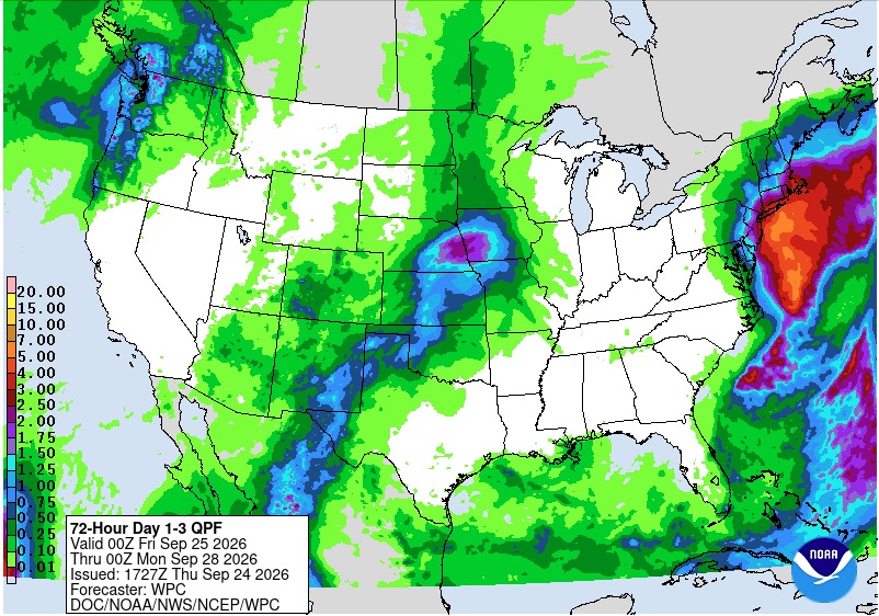
-
Strong Nor'Easter/Hybrid Storm Late September 2026
wthrmn654 replied to Rjay's topic in New York City Metro
There are coastal flood watches and coastal flood advisories for southern Nassau County and i thin south western Suffolk county issued last night. Highly expect more watches/ advisories to be issued very shortly for more areas. -

October Comes Early: Late September Multi-Hazard Hybrid Storm
dendrite replied to WxWatcher007's topic in New England
Maybe Rufus had the right idea -
October Comes Early: Late September Multi-Hazard Hybrid Storm
dryslot replied to WxWatcher007's topic in New England
Looks it on the Euro, Apples are pretty small this year with the lack of rain up here. -
October Comes Early: Late September Multi-Hazard Hybrid Storm
dendrite replied to WxWatcher007's topic in New England
LBSW -
October Comes Early: Late September Multi-Hazard Hybrid Storm
WxWatcher007 replied to WxWatcher007's topic in New England
I still think that's a bit too far south, but idk. That's the difference between meh and something far more impactful. -
October Comes Early: Late September Multi-Hazard Hybrid Storm
dendrite replied to WxWatcher007's topic in New England
Apple picking may still be on for Sunday!




