All Activity
- Past hour
-

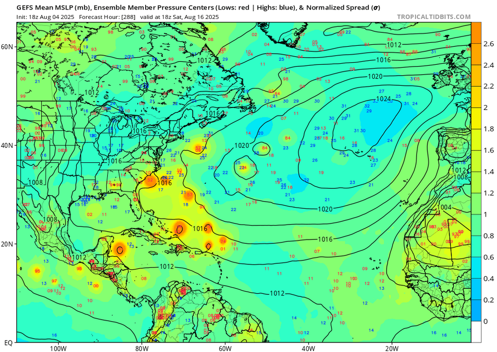
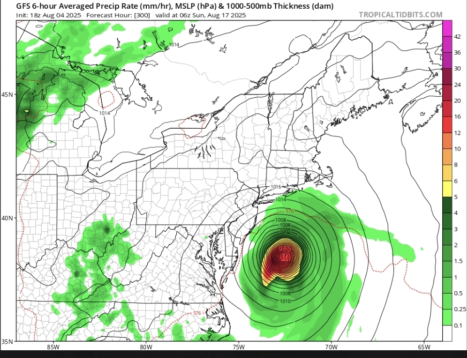
2025 Atlantic Hurricane Season
Silver Meteor replied to BarryStantonGBP's topic in Tropical Headquarters
That would be a big problem ... as it is right now the 7-day forecast for Western North Carolina is for rain every day, they sure as hell don't want to see anything from the tropics heading their way. -
 4 Day cool start to August EWR: 8/1: 75 / 63 (-9) 8/2: 83 / 62 (-5) 8/3: 85 / 63 (-4) 8/4: 90 / 65 (0) NYC: 8/1: 73 / 63 (-10) 8/2: 80 . 63 (-5) 8/3: 84 / 64 (-3) 8/4: 89 / 67 (+1) LGA: 8/1: 73 / 64 (-10) 8/2: 81 / 65 (-6) 8/3: 84 / 67 (-3) 8/4: 89 / 71 (+1) JFK: 8/1: 74 / 65 (-6) 8/2: 80 / 62 (-5) 8/3: 83 / 63 (-3) 8/4: 86 / 67 (+1)
 -
Very strong smell of smoke this evening. 70.1/65
-
Highs: TEB: 91 EWR: 90 ISP: 89 New Brnswck: 89 PHL: 89 LGA: 89 NYC: 89 TTN: 87 JFK: 86 ACY: 86 BLM: 83 *
-
Still some but the moon is fully visible and the blue sky came back right before the sun set.
-
Highs: TEB: 91 EWR: 90 ISP: 89 New Brnswck: 89 PHL: 89 LGA: 89 NYC: 89 TTN: 87 JFK: 86 ACY: 86 BLM: 83 *
-
Nothing more than poor man’s eye candy. At least the tropics are warming up. I do think we’re ripe if we keep this general summer pattern with repeated bouts of Atlantic ridging, but that becomes harder obviously as the seasonal change begins aloft in September. Everyone posts SSTs, but OHC is where it’s at. You need to keep high end tropical going as high end tropical for as long as you can along the coast. We’re not getting squat if a system is passing 150nm off Hatteras. It’s gotta tuck imo.
-
Not here
-
Wish we lived there.
-
And just like that the smoke is mostly gone.
-
 55 to 88 here. Was at Giants training camp today and it didn't feel too bad near the turf.
 -

2025 Atlantic Hurricane Season
Normandy Ho replied to BarryStantonGBP's topic in Tropical Headquarters
yea steering is all over the place in the GFS -
- Yesterday
-
 perfect weather, the high range is a characteristic of low humidity / dew point
 -
 58.8 to start 88.9 as the high
 -
1993 and 2010 are at the head of the pack.
-
And 18z this lol
-
those trees are no longer suitable in this new climate my question is why are the effects so different in different places, they've become hot and dry while we've become warm and wet? But I do think this also runs in cycles and will switch up, this was the first summer in which we hit 100 plus everywhere (that matters). I think we're at the start of a new drier cycle with more classic summers with offshore flow like 1993 and 2010 to follow. This summer was the first warning shot for what's to follow. I remember saying this last winter and even last fall during our historically dry October at the start of the westerly flow outbreak too. It's a characteristic of the switch to a -AMO. Fewer east coast TC drier and somewhat colder winters and hotter and drier summers
-
Those anomalies up north around Hudson Bay are impressive. Inuit's out on the beach like it's Miami.
-
just missed it by 1 degree
-
The high was 89 here at 3 pm before the sea breeze came in and it never felt even remotely hot.
-
Gross
-
Firefighters , Smoke eaters out in full suits
-
Thanks coc k friends . so clean , clear , refreshing https://x.com/ericfisher/status/1952480053167620361?s=46&t=dhcbvkjmRcyBVQtDxJ3lRg


