40/70 Benchmark
-
Posts
72,954 -
Joined
-
Last visited


-

2025-2026 ENSO
40/70 Benchmark replied to 40/70 Benchmark's topic in Weather Forecasting and Discussion
I could have sworn 2021-2022 was a mismatch season...interesting that we still managed a mismatch period minus the amplified October MJO....I could certainly see something like that occurring this season. I agree this season will probably be warmer with a more consistently negative PNA, yet still manage more snowfall. -
2025-2026 ENSO
40/70 Benchmark replied to 40/70 Benchmark's topic in Weather Forecasting and Discussion
-
2025-2026 ENSO
40/70 Benchmark replied to 40/70 Benchmark's topic in Weather Forecasting and Discussion
Probably warm ENSO for 2026-2027. -
2025-2026 ENSO
40/70 Benchmark replied to 40/70 Benchmark's topic in Weather Forecasting and Discussion
"40/70....I am your father" (breathes heavily) -
2025-2026 ENSO
40/70 Benchmark replied to 40/70 Benchmark's topic in Weather Forecasting and Discussion
@bluewaveSeriously, though....I do recall telling you last season that I expected your October MJO indicator to be amplified and favorable and I do expect that again, so we'll see. -
2025-2026 ENSO
40/70 Benchmark replied to 40/70 Benchmark's topic in Weather Forecasting and Discussion
I don't want to sound too optimistic because Bluewave will be on my door step. -
2025-2026 ENSO
40/70 Benchmark replied to 40/70 Benchmark's topic in Weather Forecasting and Discussion
Yea, I think we will have some servicable stretches...but overall the west-urine pool does of course remain. -
2025-2026 ENSO
40/70 Benchmark replied to 40/70 Benchmark's topic in Weather Forecasting and Discussion
@ORH_wxmanWas actually metioning the other day how this year kind of resembles some of the older cool ENSO events in that there is more cooler water near the west coast than in the recent ones. -
2025-2026 ENSO
40/70 Benchmark replied to 40/70 Benchmark's topic in Weather Forecasting and Discussion
Jinx. I will add that JMA essentially ENSO neutral, too....slight hedge towards cool ENSO, so the EMI really isn't a big deal, but I would rather have it east all things equal. Yes, snowman...I know how the Pacific looks right now...just speaking of the model. -
2025-2026 ENSO
40/70 Benchmark replied to 40/70 Benchmark's topic in Weather Forecasting and Discussion
I think we are going to see some variation and another periood of the season that deviates from the west Pac urine pool. -
2025-2026 ENSO
40/70 Benchmark replied to 40/70 Benchmark's topic in Weather Forecasting and Discussion
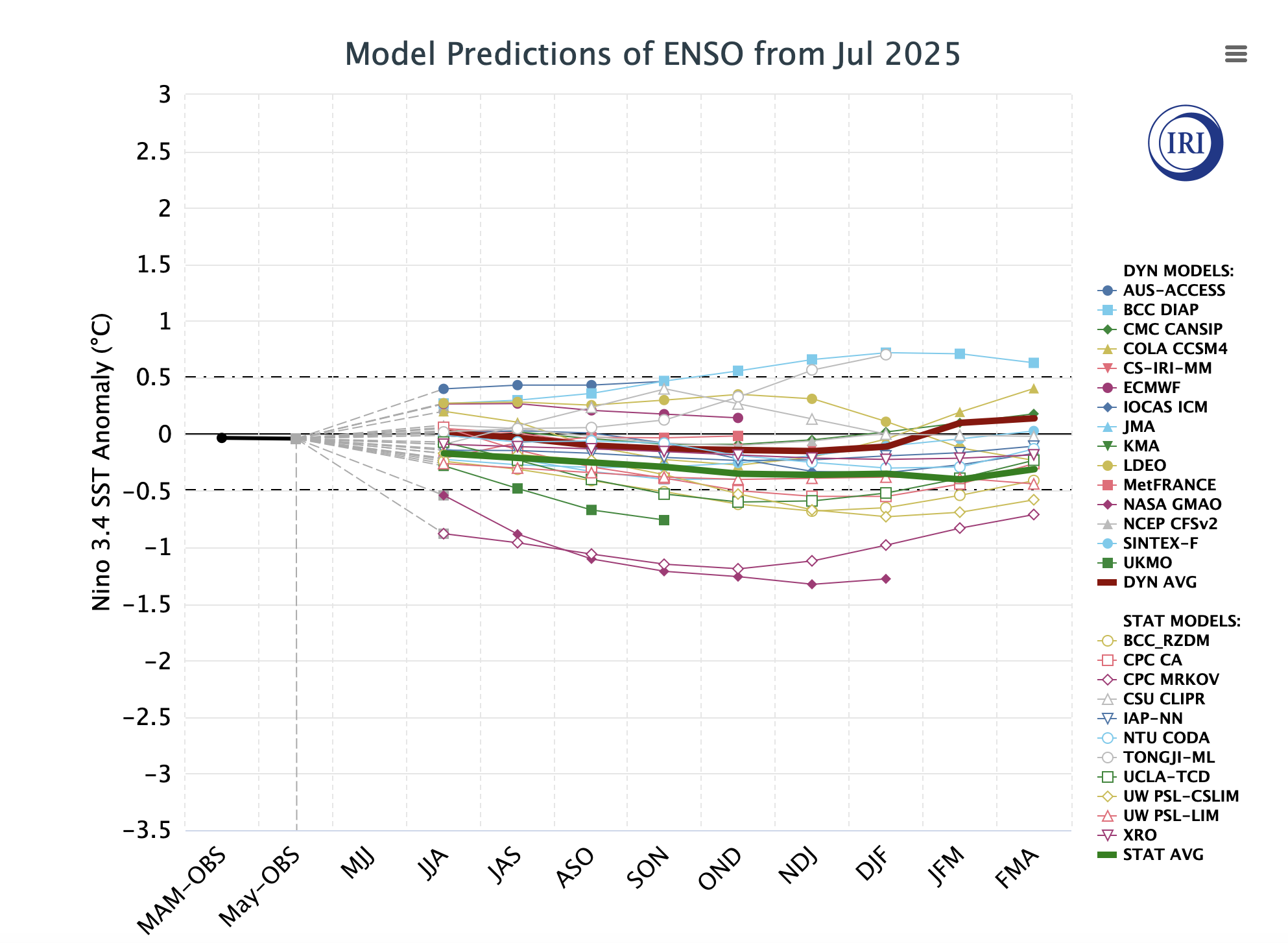
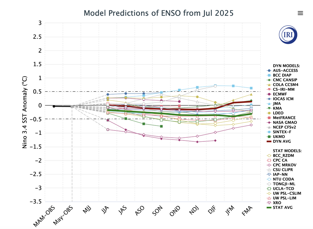
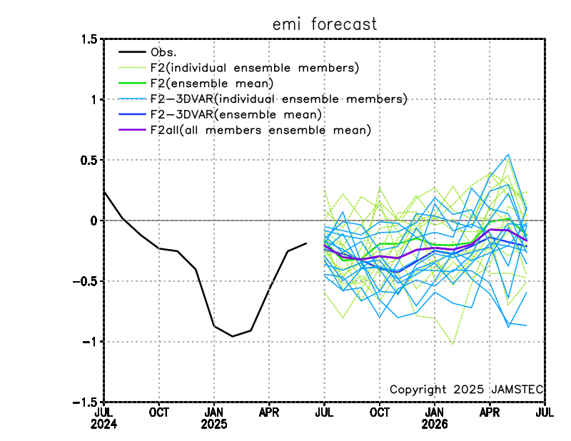
Not that its a big deal considering La Nina shouldn't be too strong, but JMA seems to imply an east based event along the lines of 2021. Just speaking of La Nina EMI...I do realize that solar is much different and La Nina will be weaker. JMA hovers the EMI around -.3 or so during the winter...which is similar to 1995-1996, 2017-2018 and 2021-2022. First of all...no, 1995-1996 is not a seasonal analog, so please spare me Bluewave's wrath (jk....kinda). But signs like this reenforce my early suspicion that this will not be a wall-to-wall death star season. -
2025-2026 ENSO
40/70 Benchmark replied to 40/70 Benchmark's topic in Weather Forecasting and Discussion
The season should def. average +NAO...I am just speaking to how favorable or unfavorable it is to steal a -NAO month or two. -
2025-2026 ENSO
40/70 Benchmark replied to 40/70 Benchmark's topic in Weather Forecasting and Discussion
Looks like August 2024 was the peak? It takes a couple of years for the solar wind to in increase enough to kick up the geomagnetic particles, which is what is the most hostile for blocking....we may sneak by with one more season that is not awful. "recent studies of seal level pressure patterns that revealed a +NAO pattern lagging solar max by approximately 2-4 years. The work of Maliniemi et al also showed that this relationship is not at all dependent on overall sunspot activity due to intra-cycle variability." Mean winter NAO index values for the four cycle phases, averaged over cycles 11 to 23. The red line represents the overall mean value of wintertime NAO (0.05). Bars represent the 95% confidence interval -
2025-2026 ENSO
40/70 Benchmark replied to 40/70 Benchmark's topic in Weather Forecasting and Discussion
It was merely making an anecdotal observation pertaining to the behavior of the PDO; nothing more. I wasn't deducing anything from it. Do I think the PDO will rise this winter? Yes...do I think that will be particulary important? No. I have already said that the PNA is likely to be more consistently negatibve than last season and that I expect the +WPO to continue. I forecast seasonal index behavior, not just weather....so the behavior of the PDO independent of the actual weather is relevent. There wasn't any emotion involved...I was simply adding a little levity to the discussion, as I so often do. But it is true that I can always discern which posts you will swarm to like an ant to spilled soda...I knew how my post would be perceived ostensibly speaking, which would prompt a replay form you. -
2025-2026 ENSO
40/70 Benchmark replied to 40/70 Benchmark's topic in Weather Forecasting and Discussion
How did I know that Bluewave's advanced optimism alarm system detected a faint modicum of hope in my post, and that he would rush to the scene to douse the flame in short order. Dude is the Darthvader of seasonal forecasting.