

RyanDe680
-
Posts
1,419 -
Joined
-
Last visited
Content Type
Profiles
Blogs
Forums
American Weather
Media Demo
Store
Gallery
Posts posted by RyanDe680
-
-
Inch maybe inch and a half at 294 and 88. Better performance earlier in the week on Wednesday.
-
Meh. South is the trend
-
 1
1
-
-
Temp dropped 15 thanks to lake breeze.
had more storms last night
-
 1
1
-
 1
1
-
-
1 minute ago, Chicago Storm said:
CU is sparse and struggling to maintain south of US-36 in MO.
Just can’t see where this is going to develop to PDFs degree
-
N IL will have this moisture linger until at least noon until 1. We would have needed clearing by then. It’s imperative in these setups - we’ve seen this over and over. The northerly flow is a big determining factor. That and an over worked atmosphere.
not saying that there won’t be storms, but perhaps not moderate risk worthy IMO and if so, further south
-
This was fun while it lasted
-
yasssss. bout time. something to do while in lockdown
-
1
-
-
Looks like the first day of March could be the highest temp of the year for Chi
-
2
-
-
3 hours ago, A-L-E-K said:
early season optimism running high in here
Means high bust potential
-
Thought I saw a flake. Was a bird feather.
-
1
-
5
-
-
1 hour ago, HillsdaleMIWeather said:
06Z NAM coming in a touch northwest
Lol. Crickets.
-
Best time of the year just starting.
-
1
-
2
-
-
LOT trimmed the watch back further. Looks anemic.
-
maybe the thinking is that these runs are too exaggerated south?? Don’t know why LOT would still have these totals otherwise
-
1 hour ago, Castaway said:
Woke up to weather channel showing 8-12” for Chicago and I’m like

came here and starting looking around and I’m like
 game still on.
No final call yet, but feeling confident 8”+ around here in Oak Brook. Coffee should be ready now
Where in oak brook are you? I’m at York and 22nd
-
GFS is a Kenosha special
-
I’ll check back after lunch tomorrow.
who am I kidding. See you at 6am.
-
1
-
3
-
-
Oh man.
7 minutes ago, DaveNay said: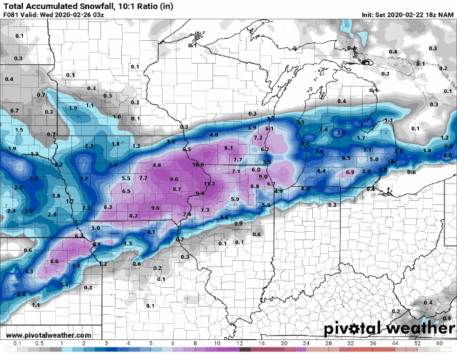
-
No nam images. Must be bad looking.
-
I dunno. Lots of optimism. During this season, that hasn’t ended so well.
-
If it weren’t for the snow cover today, we would have hit 50. Great sun today.
-
1
-
-
58 minutes ago, SchaumburgStormer said:
Another “meh” storm in a season of “meh”.
Word. Wish it was end of march already.
-
1
-
-
Bring on 60s and 12 hours of sun. #winterdone
-
5
-
-
10 minutes ago, RCNYILWX said:
If the ECMWF and NCEP idea comes to pass, the snow on Thursday stands to be well above average ratios as the cold air mass deepens over the region. Forecast soundings are showing the DGZ increasing to 200 to 300 mb deep, or as deep as 7kft+. GFS in particular has the DGZ almost down to the ground and up to 700 mb. Progged lift is modest during this time but the high ratios would compensate.
I'm also becoming more interested in the lake enhancement to lake effect component for northwest Indiana. Very good air mass with 850 mb temps down around -18 to -19C over the lake Thursday night and some of the models slowly pivoting the lake induced convergence axis. Inversion heights near 8kft, 850 mb to lake delta T around 20C and at or above 400 j/kg of lake induced CAPE could support heavy rates with > 20:1 ratios in the band.
Sent from my SM-G965U using Tapatalk
Aren’t bands in that type of setup pretty narrow?
April 15-17 Snow
in Lakes/Ohio Valley
Posted
Yeah really looks like 4" to me